Short Creek
CR 409 to Guntersville Lake(Lower Short)
| Difficulty | III-IV |
| Length | 8.2 mi |
| Avg Gradient | 77 fpm |
| Reach Info Last Updated | August 2, 2021 |
'This is a very nice though short section of Sand Mountian action. The falls at the put-in is a classic and the action continues unabated to the lake. As Short and Scarham combine just above the lake to make on last rapid one has to wonder what was covered up by the lake.' - Will Thornton
Short Creek is an excellent intermediate creek run, sporting a squeaky-clean 18-foot waterfall, a thick stack of quality rapids, and relatively straightforward (but strenuous) access logistics. Though there is a 3 mile lake paddle, and the water quality is poor (definitive 3 chickens, by the AL WW standard), this reach deserves consideration any weekend there's local water.
Short runs relatively frequently, nearly as often as Town Creek. Thanks to StreamBeam, an online gauge exists so you can check the levels before you head out! It can be found at the link below:
http://www.streambeam.net/Home/Gauge?siteID=1
The online gauge updates several times per hour, and correlates almost perfectly with the old stick gauge on the AL 75 bridge. Look for upwards of 0.5' for minimum flow, and above of 1' for good water. Above 2', holes become significantly stickier, and the boil at the base of the falls is particularly ominous. Runs down to 4-5'' on the old bridge gauge have been done without too much hassle, though at that point it's a test of your tolerance for rocks.
The listed address for the put in is approximate – look for a bridge over the creek with a gravel pull off on the river left, downstream side. It is tempting to park at the Hustleville Road bridge to cut off the warmup rapids, but the county has put up no parking signs on both sides of the bridge. If the water is high and you want a more interesting warmup, Drum Creek is a tributary which enters just above the falls and offers some nice class III water. See Alabama Whitewater for a description. The takeout is simple, park at the ranger s
...
The most common put-in is on Martling Road (CR 409), with the other option being the stream crossing at AL 75. It is tempting to put in on Hustleville Road directly above the falls, but the county has put up 'No Parking' signs at the request of the landowners.
There is a large gravel pulloff on Martling Road on the downstream, river left side of the bridge. Park here and carry your boat down to the river under the bridge.
The first three miles of river, between the Martling and Hustleville bridges, consist of easy class II/III- warmup rapids. However river-wide log jams are common, so keep an eye out if you haven't been down recently.
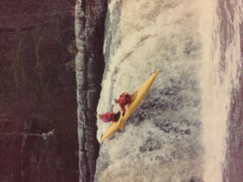
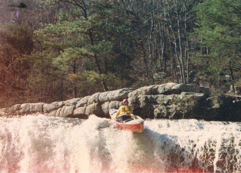
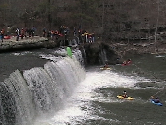
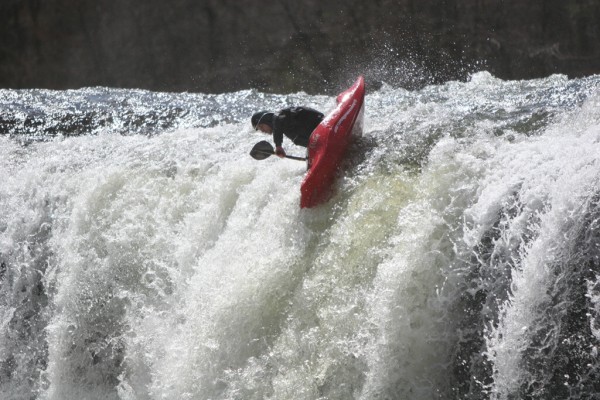
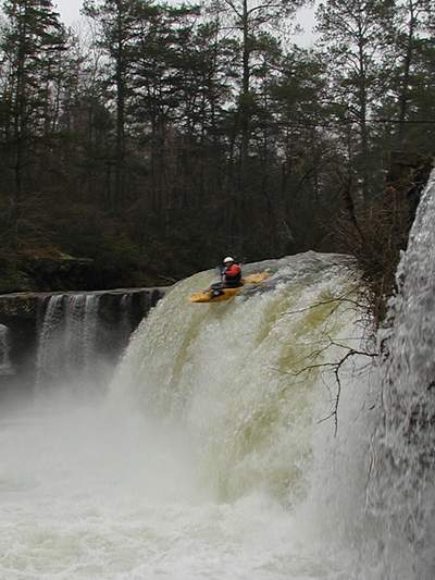
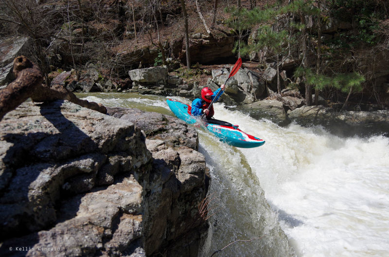
After you pass under the Hustleville bridge, eddy out on the river left bank to scout the main attraction, Short Creek Falls. If you wash too far downstream the bank becomes a bluff and blocks your exit.
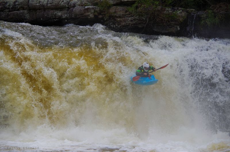
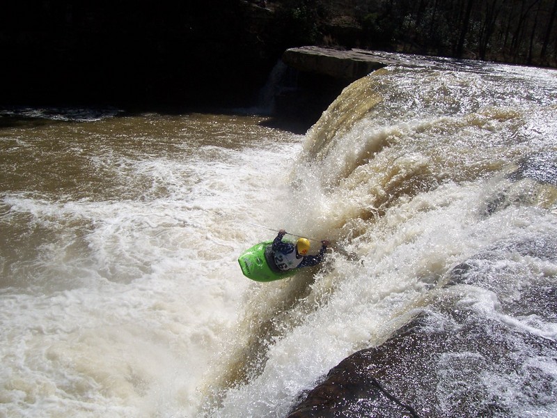
The falls are very friendly and can be run just about anywhere that has water going over. Depending on where you go it’s an 18 or 20 foot drop. The traditional line is about 10 feet off the left bank, over the top of a small curler. Just don’t go too far left, because if you land on the wrong side of the boil at the bottom, it will shove you into the mildly undercut shelf on the bottom left, where an amusing display of carping will likely ensue. Set safety from on top of this shelf. Eddy out behind it, hike back up and run it again. You can paddle behind the falls on the river right side, and watch your friends go over from behind the curtain. Pretty neat.
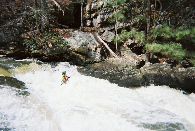
After you get bored of the falls, a few class II-III boogie rapids follow. Keep an eye on the scenery ahead; when you see a sheer cliff face ahead on the right as the river bends left, Grotto Falls is coming up. Following a small slide, beach yourself on the large rock outcropping that divides the flow to scout Grotto. The main line is just a couple feet to the left of the rock you landed on, an easy 8-footer with big boof potential. At low water, keep your boat angled right to miss a piton rock on the left side of this drop. This can also be run further river left as a double drop, just stay away from the undercut bank.
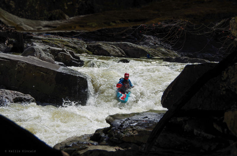
Immediately following Grotto Falls is the infamous Tornado Sluice, which has caused many swims over the years. The line is down the turbulent left channel, entering from either side of a rock which divides the flow. You want to be on the right side of the chute as you finish off, angling downriver, to avoid the recirculating eddy and rock wall at the bottom left. If you get pushed into the wall, just ride it out and roll up before the creek gets too shallow.
Another short pool separates Tornado Sluice from Divided Highway, named for a large fin rock which serves as a median separating two potential routes. Most take the right lane, entering just right of center and merging with oncoming traffic to stay afloat. The left line is navigable at medium flow and above, but has potential to cause traffic jams due to a sneaky pin rock.
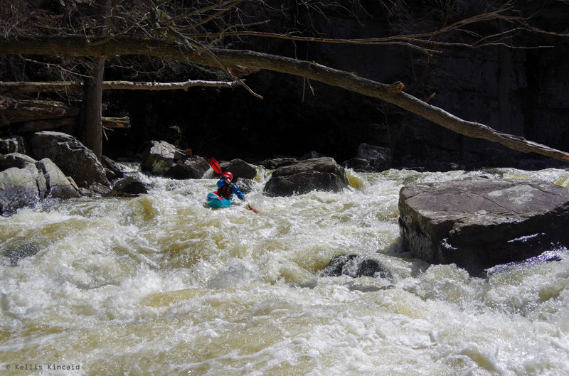
After the triple stack of Grotto, Tornado Sluice, and Divided Highway, the action continues with Rock Cruncher, perhaps the biggest rapid after the falls. Catch an eddy on the left above the entrance to scout the full rapid. If it isn’t an ELF day you can sneak down the left side, bouncing off a few rocks and into the pool below the rapid. The usual line is to work from center to right into an eddy on the right bank above the main drop; from here the line is down a chute headed back center to miss the big boulder on the right bank. No doubt you’ll spot a juicy mushroom of water at the bottom ripe for a boof – but watch out! A nasty flake rock is right in the center below the mushroom. Skim the left or right side to avoid getting crunched.
A few easy rapids follow Rock Cruncher. The next significant rapid starts after a long pool, where the river doglegs right and the left and center are obscured by large boulders. The creek widens significantly here and you'll bump and scrape through the top part of this rapid, which has a few possible routes; the most entertaining option is a tight 3' boof against the far left bank. When the creek begins to channelize again, be wary as the majority of the current barrels down into Little Woodall, a dangerously sticky hole which is known to recirculate boats and swimmers. The safe line is to power into the eddy to the left of the hole, beside an enormous rectangular rock, then wheelchair down the rocks which form the pool on the downstream side. The more adventurous may wish to run the hole off the left shoulder, but be prepared to set safety if anyone plans on doing so.
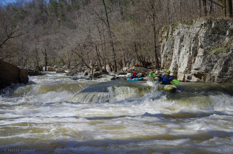
After Little Woodall, some congested boogie water leads to the confluence with Scarham Creek. Hike up and take a look at the last rapid on this tributary, known as Terminator (class IV or V), and run it if it looks good to go. Below here the creek widens significantly, and with the added flow from Scarham, presents some good play opportunities to celebrate finishing the hard stuff. Surf waves and fun boofs abound. Look for a good ender hole in the second rapid past the confluence on river right.
After a number of wide, easy rapids, you'll reach the lake. If you work far right on the last rapid, you'll find a fun 4 foot boof to end the day with. Additionally, the eddy line on far river left (or is it lake left?) presents one last opportunity for stern squirts as the creek dumps into the lake.
Once you reach the flatwater, celebrate the fact that you made it down the notorious Short Crick, and prepare yourself for the 45-minute, 3-mile paddle out. Just follow the channel all the way to the boat ramp. When the lake doglegs to the left for the first time, don’t get too close to the island or you’ll run aground.
Mar 3, 2007
short on right, scharam on left