| Difficulty | III-IV(V) |
| Length | 3.5 mi |
| Avg Gradient | n/a |
| Reach Info Last Updated | April 14, 2020 |
River Description
Not to be confused with Cathance Stream in Washington County.
Posted by Justin Manter on 4/4/02
This is a gorgeous class III- IV creek run with 2 optional class-V waterfalls for the stout of heart. The river is very wild despite its location and the scenery is excellent.
There is a walking/hiking trail along river right for most of the rapids in this stretch great for scouting or doing laps. This river is rather uncharacteristic of many in the area, as it is mostly made up of short, rocky, often very steep rapids separated by long sections of barely moving flatwater. The rapids are the river stepping down from ledge to ledge as it makes its way to the ocean at the takeout.
Rapid distances are calculated from the Rt 201 bridge and are approximate.
Video of some folks paddling a few years back (rapids not pictured in downriver order): https://www.youtube.com/watch?v=mAqMT0LRBpI
River Features
Put In
Access PointDistance: 0 mi
First Drop
OtherClass: IIIDistance: 1.3 mi (approx.)

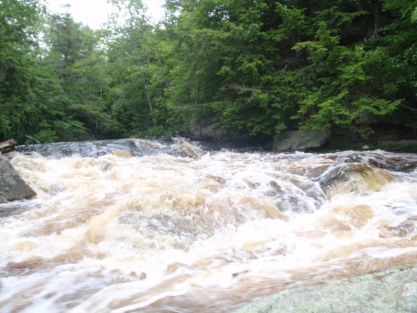
Longest rapid on the river, scout the whole thing from the walking trail on the right for wood before running. Starts with a ~100 yard fairly mellow lead in that enters a walled gorge. Immediately after the gorge there is a small moving pool with an eddy on each side before the rapid continues. The main flow goes right, though at higher flows there is a channel on the left as well. The two channels come back together before all dumping into a hole at the bottom of the rapid that can be sticky depending on the level. Right side of the hole is good for a boof, or if you go far left you can ride around it. Total length is about 200-250 yards.
Second Drop
OtherClass: IIIDistance: 1.6 mi
River takes a turn to the left, catch the eddy straight ahead on river right just before the diagonal for some added excitement. The diagonal is a notorious boat flipper, take caution.
Cave Drop
OtherClass: IVDistance: 1.75 mi
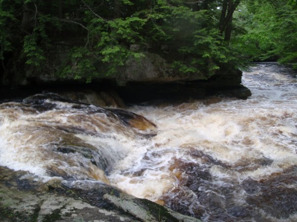
Easily scouted from the rocks on river right. At most levels you can paddle right up to the lip of this and get out there. This rapid goes down a ledge starting left and moving toward the center right of the river bed. There is a flake on the left side of the ledge that does not offer as smooth a boof as it looks and often leads into the cave on river left. Take the tongue from left to right and you'll plug a bit more but have a smooth line through the rapid.
Boulder Pile
OtherClass: IIIDistance: 1.95 mi
Another rapid where the river turns left and drops down a ledge level. In this one, there has historically been a giant tree/log on the right that isn't to be messed with. Stay left/center and take the smooth road down into the boulders, where things are bound to get a bit bumpy.
Magic Carpet Ride
OtherClass: IV+Distance: 2.2 mi
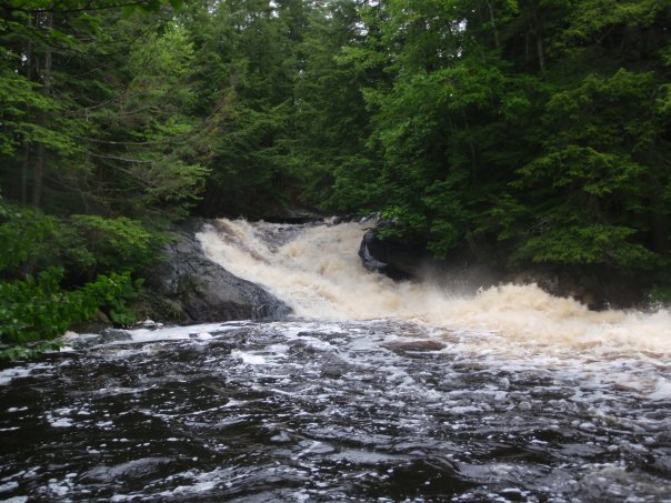
Big slide turning left around a corner dropping 15-18 ft. Recommended path through the entrance rapid is to stay right for best line-up to the slide, catch the eddy on river right to really line it up nicely. Optimal line down the slide is as far right as possible with right angle to avoid the hole at the bottom and skip out into the eddy. The center and left at the bottom of the slide are two large holes, one after the other. There is a rock hidden in the foam pile of the first one causing the second, be careful to not plug too deep or you may hit it. Some consider this class V, though most agree it is closer to IV-IV+.
Naz's Hole
OtherClass: IVDistance: 2.35 mi
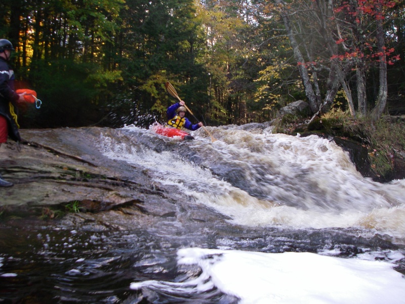
Final rapid of the run for most folks. The hiking trail out is right next to this drop. This is another slide somewhat similar to the previous though a bit more straightforward. Again, it is best to stay right, as the left can get nasty. However, there is a nice move that can be made with a pour-over rock on river left above the slide known as the 'Linehan Boof' that can be made before driving right.
Take Out
Access PointDistance: 3.5 mi
Ankle Breaker
Waterfall / Large DropClass: IV+Distance: 3.55 mi
This waterfall is just after the takeout at Head of Tide Park and is the point where the Cathance reaches the ocean. At high (and preferably VERY high) tides, this can be paddled carefully, though it is best to thoroughly scout the landing zone. As the tide goes down, it rapidly exposes rocks and mud flats.
Trip Reports
Log in to add a reportEN
4-4.5 on the bridge - Eric Nathanson
May 15, 2025
Had a great high water paddle at a little over four on the gauge. All the drops were clear of wood in the mainlines, though a few logs pinned on the sides where they could cause problems for someone off line.
One of our group learned the hard way not to go too far right on Magic Carpet.
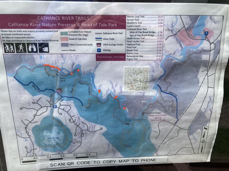
I've included a map of the hiking trails for folks to reference with the drops marked in orange. Fastest way out in the need of a walk out is to head back towards the ecology center.
NP
Nate Pendergrass
May 3, 2018
ran it at 3.5 on the gauge strainer in the first rapid but clear from there