South Sauty Creek
Intersection of County Roads 43 and 56 to Bucks Pocket
January 1, 1900
Trip Report
| Reporter | Robert Maxwell |
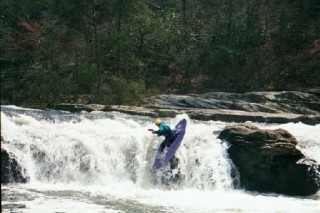
Duncan Cottrell running South Sauty Falls. The falls are a very short hike upstream of the put-in bridge.
Duncan Cottrell runs the top drop of Welcome To Sauty
Duncan Cottrell runs the bottom drop of Welcome To Sauty
Peter Horne Runs Cliff Left. Gee, I wonder how it got its name?
Peter Horne makes Bone Crusher look easy.
Marshall Fox running Egg Scrambler. Look to the right of the photo and you'll see a large set-up eddy at the base of the cliff where everyone is waiting their turn.
A good visual gage for South Sauty Creek is the low water bridge that crosses it at the entrance to Buck Pocket State Park. In this shot, there is about 5' of water flowing over the bridge which translates to 0.75 on the South Sauty paddler's gage. The creek is runnable when there is a thin sheet of water flowing over the bridge. 1 foot of water is over the bridge is 1.5-2.0 feet on the gage. If your car will get swept downstream into the lake its over 3.0 feet on the paddler's gage.
South Sauty Creek is easily boat scouted and offers a lot of on-the-fly water reading technical fun.
South Sauty Creek is easily boat scouted and offers a lot of on-the-fly water reading technical fun.
Here's Jim Strickland running South Sauty Falls. The falls are 1/4 mile upstream of the put-in bridge.
The paddler's gage is about 200 feet downstream of the ranger station (and hot showers!).
The Slot is one of the most impressive rapids on South Sauty. Look out for the sieve under the river left boulders.