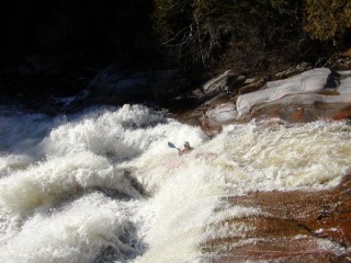
Nesowadnehunk Stream
Little Niagara to Penobscot R.
| Difficulty | V |
| Length | 3.1 mi |
| Avg Gradient | 155 fpm |
| Reach Info Last Updated | February 19, 2014 |
Source: Greg and Sue Hanlon's Steep Creeks of New England, which has more info on this run. Text used with permission.
Directions: From Millinocket, drive NW to Baxter State Park. Unfortunately, the roads are closed in the Spring. Guess when the Nesowadnehunk Stream usually runs! Sooooo...carry upstream from the confluence with the West Br. Penobscot. Bowater Company owns the road along the West Branch of the Penobscot (the Golden Road) and may charge an access fee to enter this area. Park in the pulloff at Nesowadnehunk Falls and put in on the West Branch Penobscot. Paddle down to the confluence with the Nesowadnehunk Stream. Hike 2.5 miles upriver on the Appalachian Trail to an old dam site above Little Niagara Falls. Here's the putin.
Takeout: drive downstream from Nesowadnehunk Falls until the logging road joins the West Branch Penobscot at the Abol Deadwater. This is a convenient takeout.
If you're lucky enough to find the park roads open, enter the park at the Togue Pond Gate and bear left at the first fork. Follow this road past Tracy Pond. Take a left toward the Daicey Pond Campground; put in along this road.
River Description by Nate Warren:
Nesowadnehunk Stream flows down Mount Katahdin into the Penobscot River, directly below Nesowadnehunk rapid on the Penobscot. Depending on whether the roads through the park are open, the run can be hiked up, driven up through Baxter State Park, or accessed via the Golden Road on river right. This last option uses side logging roads off of the Golden Road to access the river, and the Delorme Gazetteer for Maine does not always match the passable roads on the ground.
If you are driving in, especially via the Golden Road, there is a good chance you will put in well above the first major rapid, Little Niagara. The few miles above are largely flat, meandering stream wit
...Jun 14, 2007
You can save yourself the park access fee and shave a few minutes off the shuttle by accessing the run from the Golden Road. From the take out river right on the Penobscot, head upstream on the Golden Road, then make a right over the bridge that crosses the river just above the Cribworks. Continue on this road for approx. 5 miles and then look for a right onto a logging road which will dead end after 3 or 4 miles about 500 yards before Nesowadnehunk Stream. There are a few turns you will have to make on the logging road that aren't clearly depicted on the Maine Gazateer, but trust your instincts and you'll get there. Bushwhack the remaining distance along an overgrown snowmobile trail until you hit some park facilities and the river. This will add about 8 river miles to your day - meandering Class I in a beautiful high alpine setting, briefly punctuated by 2 Class IV series of rapids.
Jan 19, 2004
Flowphone is no longer available, flow must be checked at take-out. If Gulf Hagas is high (10 inches+)Nesowadnehunk should be ok.
