Baker Creek
Ed Banks Road to Weyerhauser Road 52200 (3 miles)

| Difficulty | III-IV |
| Length | 4 mi |
| Avg Gradient | 50 fpm |
| Gauge | Cossatot River Near Vandervoort, Ar |
| Flow Rate as of 16 minutes | 3.13 ftbelow recommended |
| Reach Info Last Updated | April 7, 2014 |
Take-out: Main one is on Weyerhauser road 52200, the first road to the left East of the Hwy 278 bridge over Baker Creek. Take-out at Hwy 278 is possible, but parking is very limited.
Put-in: Reached by continuing across the low-water bridge at the take-out and follow the signs to the Ed-Banks Access for the Cossatot. If low-water bridge is not crossable, return to Hwy and take first road West of the Hwy 278 bridge over Baker Creek. Once reaching the intersection for Ed Banks access to the left (West) and Hwy 246 straight ahead (North), There will be a gated road to the right (East). State Park Ranger reportedly will unlock the gate on days the Cossatot is above 5 ft. This is timber land leased to two different hunting clubs. The Park Ranger is working with the paddlers, timber company and hunting clubs to help open the access more regularly. Hopefully a better system will be worked out soon.
Optional put-in for higher water if gate is locked is from Hwy 246. Water needs to be over the take-out bridge for this option. First half mile will be small and brushy until several tributaries add to the volume. This adds another 3.7 miles to the run. Several good fun class III drops in this section of continuous rock gardens and ledges.
The main rapids are in the first mile below the main put-in.
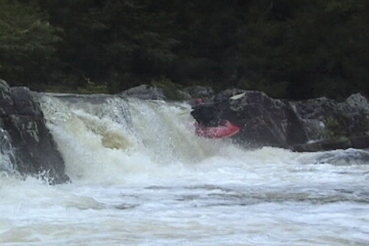
A couple short steep rock-jumble rapids lead into the first big drop below the main put-in bridge. The creek makes a sharp right hand bend as a small cascade enters on the left. Scout/portage on the right. Watch the hydraulic at the bottom of the big drop at high water levels, it has nearly killed on some high water runs. At optimum levels, aim for the launching pad for a sweet boof. Watch for piton rocks at lower levels.
Several more steep/tight class III/IV rapids follow in quick succession. Pins can be common at lower levels and sticky holes are the norm at higher levels. These consist of tight rock jumbles and sm
...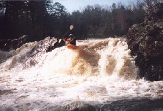
Main Drop: Aim for the launch pad and fly!
Beware of the hydraulics at high water levels. Beware of pitons at low water levels
Main line 1/4 way off right bank. Alternate line on left with right angle.
No trip reports yet.