Black
D) Narrows Park to Conglomerate Falls (8 miles)

| Difficulty | II-III+ |
| Length | 8.5 mi |
| Avg Gradient | 24 fpm |
| Gauge | Black River Near Bessemer, Mi |
| Flow Rate as of 20 minutes | 1.94 ftbelow recommended |
| Reach Info Last Updated | March 1, 2022 |
Quick Facts:
Location: Western Upper Peninsula, MI, about 5.5 miles NNE of Bessemer.
Shuttle Length: 6.8 miles. (See details in 'Directions' Tab.)
Character: Beautiful northwoods run. Mostly open easy rapids, finishing with a big drop.
Drainage: 200 sq.mi. (at gauge site 5 miles upriver).
(Description based on one run, at 275 cfs.)
This run starts off with perhaps a mile of easy wide boulder-garden rapids with a few minor (at this water level) playable waves. At mile 1.5, Reed Creek enters from the left. Mostly flatwater continues until nearing the Copper Peak Ski Flying tower. (This can be used as an alternate put-in to cut off some of the (mostly uninteresting) length of the run. This would likely put you below the following described drop.)
Chippewa Falls (about mile 3.4), a somewhat technical, wide, boulder jumble drop (class II-III) of maybe 50 yards precedes a right-hand bend in the river. This was easily boat-scoutable. (Obviously, it is much more of a 'rapids' than a 'falls'.) A few random waves and holes follow before action subsides for a bit. At mile 4.0, Kirby Creek enters from the right, followed almost immediately by a backroad crossing.
Before long, the character of the river changes. Instead of the wide open grassy shores and red-granite boulder strewn stream (as it had been down to this point), you encounter an area of vertical walls and sloping bedrock drops with a couple random appearances of conglomerate, hinting at the character of the river in the lower reach. Again, at 275 cfs, all was boat-scoutable. A couple drops provided great surf opportunities. My guess is that with perhaps 1.5-2.0 times as much water (400-500 cfs or higher), some holes could become rather meaty, and provide (intentional or unintentional) rodeo activity. (I believe the main drop in this area is what is marked on maps as Algonquin Falls (5.7 miles). Again, it is much more o
...Look for a little (unofficial) wayside (small clearing) on the east side of Black River Road (just opposite a home on the west side of the road).

Labeled 'falls', but really much more of a rapids. This is (more-or-less) at the base of the Copper Peak Ski Flying Area.
Again, much more of a squeeze/ledge/rapids than a 'falls'. At medium to higher flows, this could get quite sticky (class IV-ish). At some flows this might be a great playspot (if one can catch it in warm enough conditions or be of that mindset).
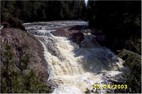
Now, THIS one is really a FALLS! Recommended to scout this drop!
At low-to-moderate flows, this can be done from a hump of rock which splits the flow. At higher flows, scouting from there may not be possible (or advisable, anyway). There may be multiple possible lines, down either side of the conglomerate rock.
The most usual route is immediately left of the largest hump of rock, though at higher flows, routes open up down the right side.
It is a rather long trudge back to the parking lot from here.
Depending on flow and boater's inclinations, take-out may be above (without running the drop) or below the falls.
Feb 10, 2011
Ran this section during the 2010 fall rains. The level for the lower black was 2100cfs (it was huge!). We decided to run this section and it was an amazing run. all of the class II turned into III and the two main rapids turned into big water IV. There were some crazy death holes, but they were easily avoidable. If you get the chance to run this section during flood its way worth it.....just be careful.
John LaGow
Jan 1, 1900
Conglomerate Falls at a fairly low level.