Big Fork
A) Hwy.1 wayside to Little American Falls picnic area (18.3 miles)
| Difficulty | II(IV) |
| Length | 18.2 mi |
| Avg Gradient | 2 fpm |
| Gauge | Big Fork River at Big Falls, Mn |
| Flow Rate as of 41 minutes | 86 cfsbelow recommended |
| Reach Info Last Updated | April 2, 2019 |
Quick Facts:
Location: NorthCentral Minnesota, approximately 13 miles NE from Bigfork, 136 miles NW from Duluth.
Shuttle Length: 12.7 miles. (See details in 'Directions' Tab.)
Character: Northwoods canoe tripping, mostly flatwater, light rapids and one falls.
Put-in elevation is approximately 1280'.
Take-out elevation is approximately 1240'.
Thus total elevation change is approximately 40'.
Information (lat, lng, elev, total drop, run length, shuttle length) adjusted and/or verified from best manual extrapolation of online data (via maps.google.com, distance measuring tool, and other resources). 2009.04.15
The resolution on Google Maps for this area is pretty good. Go to the 'Map' tab, click 'USGS Aerial' 'Satellite', double-click near the put-in, zoom in to the maximum resolution available (without losing image), and do a 'virtual walk' of this reach!
General Overview
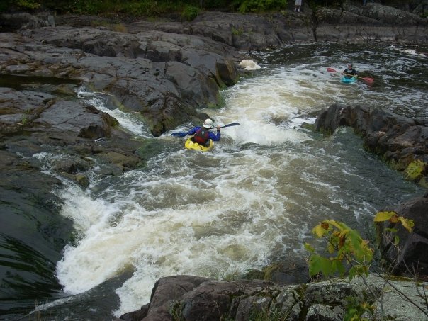
This reach includes class I rapids, a half-mile stretch of Class II (Muldoon Rapids), and Little American Falls, described in a MN DNR brochure as 'a six foot ledge into a deep pool flanked by 60 foot bluffs.' It lists conflicting ratings for the drop, once calling it Class III-IV, and later calling it Class IV-V. (I anticipate the former is more likely correct by current standards.)
Boaters may use alternate access to shorten the trip (perhaps even just doing a 'park-and-huck at the take-out falls?).
Cliff Langley provides (2011-03-21):
Little American Falls is a very scenic drop you can hike to from a trail in the Little American Falls campground. The falls is a class III+, or class IV if really juicing. It is basically one move, line up and go off a 4 to 6 foot drop. It didn't seem worth the bother of hiking up and down a long (hundred yard plus) staircase for one drop that would take 2 seconds to run. Nice spot though, cool campsite only accessible by wat
...
Topo maps indicate 'rapids' upstream and down from the highway. From the 'Satellite' view at best resolution, they are not evident. It seems likely this is little more than a rocky shoals.
Another (non-evident from 'Satelite' or 'USGS aerial' view) topo-map marked 'rapids'.
Topo maps indicate a 'rapids' here, but again, they are not evident from 'satelite' or 'USGS aerial' views.
Muldoon Rapids appears to be a low-grade (maybe class I-II?) rock-garden stretching for nearly a half-mile downriver.
This will be the (whitewater) highlight of the trip.
Drainage area at this location is about 962 square miles (per USGS StreamStats Beta software).
No trip reports yet.