Thanks to everyone who took the time to write letters and/or attend the water board meeting in
If you have already made comments you have received a notice from the IDWR about how the water board has made a few changes to the plan and has opened the plan for more public comment until April 23, 2004. In addition, a meeting on the plan will be held at the Grangeville Senior Citizens Center at
THINGS YOU CAN DO:
IF YOU HAVE NOT YET HAD TIME TO MAKE COMMENTS:
please send in comments by April 23 (see the bottom of this email for talking points and background.)
IF YOU HAVE ALREADY SENT IN COMMENTS: THANK YOU!!
A short follow up to the water board will let them know of your continuing interest. You could make reference to your previous comments and emphasis that:
* Natural river status should be the designation for all streams that meet natural river criteria.
* You expect them to set minimum stream flows as recommended in the draft plan.
ATTEND THE PUBLIC MEETING ON APRIL 1 AT
Due to the overwhelming support of the plan the water board could not justify making the sweeping changes to the plan that they might have liked. Here are the major changes they made:
1) Changed the designation of several roadless area streams from “natural” to “recreational” status under the state protected rivers portion of the plan, basically only allowing segments already in the wilderness to be given “natural” status. The “recreational” designation would revert to “natural” if the roadless areas affected were ever protected as wilderness. [Note: Wilderness designation is not a criteria for a natural river. All of the segments being downgraded to recreational fully meet the criteria for a natural river.]
2) Wording was changed in the plan to say the board will “consider setting” rather than “will set” minimum stream flows in the basin. While this wording is not as strong as the original wording, the board says it is still intent on taking the minimum stream flows through the process.
TALKING POINTS FOR COMMENTS
1. Support instream flows for all rivers in the plan. Stress that these flows should not be subordinated to future claims. Let the water board know that you expect them to set minimum stream flows as recommended in the draft plan. [See changes in the plan above.]
2. Support state protected river status for all recommended rivers. NATURAL RIVER STATUS SHOULD BE THE DESIGNATION FOR ALL STREAMS THAT MEET NATURAL RIVER CRITERIA.
3. Let the board know if and how you recreate on the South Fork Clearwater and how important maintaining flows and water quality are to you for fishing, floating, camping, hiking, etc.
4. If you live in
5. Support the addition of instream flows for the Lower South Fork Clearwater River.
6. SUPPORT THE 20 PERCENT EXCEEDANCE BEING PROPOSED FOR SOME OF THE TRIBUTARIES. [this one is difficult to explain, but the bottom line is that the lower the exceedance percent the higher the volume that can be applied for. In small tribs this may only mean a few cfs in flow but it represents a significant increase in habitat available] Background: the Water Board is balking at asking for the 20 percent exceedance. Their rational is they have never done this before (their normal exceedance is 50 percent), and that if they ask for 20 percent then everyone will ask for 20 percent. In this case the forest service has made a strong case for the 20 percent on certain streams. Any other applicant would have to be able to justify their claim on the streams they are applying for, so their fear of this becoming the standard is unjustified.]
7. Point out the benefits to the local economy of minimum stream flows. For example, the steelhead and salmon fishing seasons bring in a lot of money for local merchants in Kooskia. No water, no fish, no money
WHERE TO SUBMIT COMMENTS
1. Send e-mail comments to Thomas Grant at tgrant@idwr.state.id.us
2. Send written comments to:
1301 North Orchard
Send copies of your comments, written or e-mail, to the following water
board members:
Jerry Rigby
_Dick Wyatt
3. Send comments online via an easy to use form at:
www.idwr.state.id.us/inc/SFCResponse.asp
WHAT DOES THE PLAN DO?
The Comprehensive Plan for the South Fork Clearwater addresses the
conservation, development, management and use of unappropriated water in the
basin.
Idaho Department of Water Resources has recommended to the board that
minimum stream flows be dedicated throughout much of the basin. In addition,
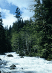
over 370 miles of rivers are recommended for state protected river status.
Important habitat areas for spring and fall chinook, steelhead, bull trout,
redband trout and westslope cutthroat trout will benefit. Wilderness
streams like Johns and Tenmile Creek will receive protected status and
minimum flows. Most of the stream miles recommended are on the Nez Perce
National Forest.
One thing that is different about this plan is that minimum stream flows are
being requested based on life cycles of fish, i.e. different flows are
requested for different times of year depending on the need. In other words,
this acknowledges that “one flow does not fit all”.
For more detail and a full list of proposed streams, please go to:
_http://www.idwr.state.id.us/waterboard/planning/SF%20Clearwater/South%20Fk.h
tm
_*BACKGROUND*
MINIMUM STREAM FLOWS
Definition: A minimum stream flow is the amount of flow necessary to preserve stream (or lake) values. The water remains in a reach or a river to protect fish and wildlife habitat, aquatic life, navigation, transportation, recreation, water quality or aesthetic beauty.
* All water rights applications that are already in place would still have senior rights, i.e. their needs will be met first. In the S. Fork basin these prior rights are generally small and there is still enough water to meet the needs for fisheries and recreation.
* The water that is left after appropriation for minimum flows would still be available for water rights in the future, though they would be junior to the minimum flows, i.e in low flow years minimum flows would take precedence over these later filed water rights. There may be a small amount of unappropriated flow that will be reserved to be used as senior rights in the future, allowing for growth in the basin. However, we want to be sure that minimum stream flows will not be subordinate to ALL unappropriate flows. This would render the minimum flows meaningless while allowing the IWRB to claim they are supporting minimum flows.
Why do we need minimum stream flows when we have plenty of water in the S. Fork? While water quantity in the S. Fork is not currently a problem, under
STATE PROTECTED RIVERS
The state protected rivers program protects rivers below the mean high water mark. When a river becomes protected, the Board designates it as either a “natural” or “recreational” river, depending on its resource values.
* “Natural” designation prohibits construction or expansion of dams or impoundments, construction of hydropower projects, construction of water diversion works, dredge or placer mining, alterations of the stream bed and mineral or sand and gravel extraction within the stream bed
* “Recreational” designation: On recreational rivers the Board may choose which of the above to prohibit.
*No provision of this program can limit, restrict, or conflict with approved water rights or vested property rights existing on the designation date.
*State protected rivers only cover the river bed itself. Property along the stream banks are not affected.
Bonnie Schonefeld
lochsa@camasnet.com
926-0921