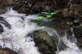
American Whitewater worked with Duke Power and other Stakeholders to provide realtime flow information for the Nantahala River through a multi-year dam relicensing process. AW was interested in gaining better flow information on the Cascades and Upper Nantahala sections, around which the Nantahala River is bypassed through a large tunnel. While the Nantahala’s main flow is bypassed, Whiteoak Creek and other tributaries regularly provide boatable flows in the reach after significant rains. The gage is now online at: http://waterdata.usgs.gov/nc/nwis/uv/?site_no=03505550&agency_cd=USGS
The gage is downstream of the powerhouse so the flows include water released into the Lower Nantahala. However, the Nantahala releases one specific flow nearly every day, so it will be fairly easy to subtract that amount out and get a solid estimate of flow in the Cascades and the Upper Nantahala. While the gage now only contains data in feet, it will soon include the CFS in the river. American Whitewater looks forward to the development of a detailed rating curve that will allow paddlers to know whether the Cascades are running or not. We are excited to have provided such valuable information to the paddling community, and hope it increases your enjoyment of this beautiful stretch of river. We will post additional information regarding how to use this gage as the information becomes available.
In addition to this flow information, new river access areas will be built along the Cascades and Upper Nanty, and 8 recreational releases will be provided annually beginning in 2006. An increased base flow in these reaches will also improve angling, ecological functions, and will slightly increase boating opportunities.
FYI
The minimum acceptable flow for the Cascades was found to be somewhere between 100 and 250 cfs, with an average of about 175 cfs. The optimal range of flows was in the 250-400 cfs range.
The Paddling Flow Study for the Cascades and Upper Nantahala can be read at:
You can read the Nantahala Settlement Agreement at