American Whitewater and the Eugene Water and Electric Board (EWEB) cooperated in a land-based reconnaissance whitewater boating study on the Upper McKenzie and Smith rivers, 70 miles east of Eugene Oregon. The Carmen – Smith Project is EWEB’s oldest hydropower endeavor. EWEB has initiated the relicense process for this hydro project (relicensing website). The project includes three dams and two reservoirs, partially dewaters a two and a half mile stretch of the McKenzie River and totally dewaters a two and a half mile stretch of the Smith River.
Although whitewater kayaking has been documented on reaches around the project, there is no documented use on the reaches actually affected by the project. Due to the difficulty of access and lack of information regarding potential whitewater opportunities, American Whitewater proposed a land-based reconnaissance boating study that would be broken down into two phases: 1) Land-based reconnaissance whereby participants inspect river reaches for whitewater opportunities and answer pre-developed survey questions and participate in focus group discussions; 2) on the water boating study based on the results of phase one.
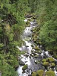
The land-based reconnaissance took place on Saturday, October 23rd. Doug Whittaker and Bo Shelby, representing Confluence Research, conducted the study. Boating participants in attendance included Kim Bates, Ed Fredette, Steve Stuckmeyer, Jim Reed and myself. We started with the Smith reach, which is totally de-watered by the Smith Dam, except for a minimal flow, approximately 10 cfs according to EWEB sources. We hiked along the reach starting from the top of Smith Dam. Overall it seemed as though the Smith River has whitewater potential. There is no flow regime for the Smith because Smith Dam is not designed to spill except in emergencies. Smith dam’s sole purpose is to maintain the Smith reservoir for managing the flow regime between inflow from the Carmen Diversion Dam and outflow to Trail Bridge Reservoir. Spills over the dam only occur during very high water events.
After the Smith reconnaissance we drove to the Upper McKenzie and started the second part of the study at the Carmen Diversion Dam by talking about the hydrology of the reach. The section of the Upper McKenzie affected by the Carmen Smith Project extends from the Carmen Diversion Dam, down to the Trail Bridge Reservoir; it is split roughly in half by Tamolitch Falls. Tamolitch Falls is approximately 70 feet high, according to Forest Service measurements, and dry except for spills over Carmen Diversion Dam caused either by high water events or project maintenance. We hiked quickly over the upper half, which is naturally dewatered by porous lava rock and has little whitewater potential. At Tamolitch Falls we explored the river bed thoroughly to examine the falls as a potential whitewater opportunity, and the short section directly above it. The group agreed that the falls has the potential to be run at higher flows. We examined access issues at this point and determined that there is the possibility of access from highway 126, which would greatly increase the run’s accessibility.
We hiked the rest of the stretch, stopping frequently to examine individual rapids. Overall the stretch below Tamolitch Falls has some interesting rapids, and not too much wood. There is the potential for a solid Class III run interspersed with some Class IV. About halfway through this lower reach the gradient drops off and there are many downed trees along the banks with some crossing the river. The whitewater on this lower stretch was minimal at the observed level, but could perhaps become more interesting with increased flows. We finished the day at the EWEB project garage by debriefing the study and recording our thoughts and impressions with Doug and Bo. There was consensus among the boaters that there definitely exists potential for boating on the Smith reach and the lower McKenzie reach, starting somewhere above or below Tamolitch Falls and finishing at Kink Creek, or perhaps going all the way to Trail Bridge Reservoir. The segment from Kink Creek to Trail Bridge Reservoir might become less attractive for boating because of the Forest Service’s plans to put in downed trees for salmon habitat.
Three weeks after the formal study Andy Potterf, another local Eugene kayaker, and I went to Tamolitch Falls and explored the access possibilities from state highway 126. There is a dirt forest service road off of highway 126 that accesses a ridge directly above Tamolitch Falls. There is a steep but manageable trail from this forest service road down to Tamolitch pool. It took Andy and I ten minutes to hike down and we both agreed that it could be done with kayaks. The determination of whether to conduct the second phase of the study should be made by EWEB and American Whitewater before the end of 2004.
Additional Information: