Wind
3 miles to 7 miles below Dubois (Fish Canyon)
| Difficulty | II-III |
| Length | 6.1 mi |
| Avg Gradient | n/a |
| Gauge | Wind River Above Red Creek, Near Dubois, Wy |
| Flow Rate as of 1 hour | 896 cfsrunnable |
| Reach Info Last Updated | May 2, 2019 |
Lat/longitude coordinates are a SWAG.
Jun 5, 2023
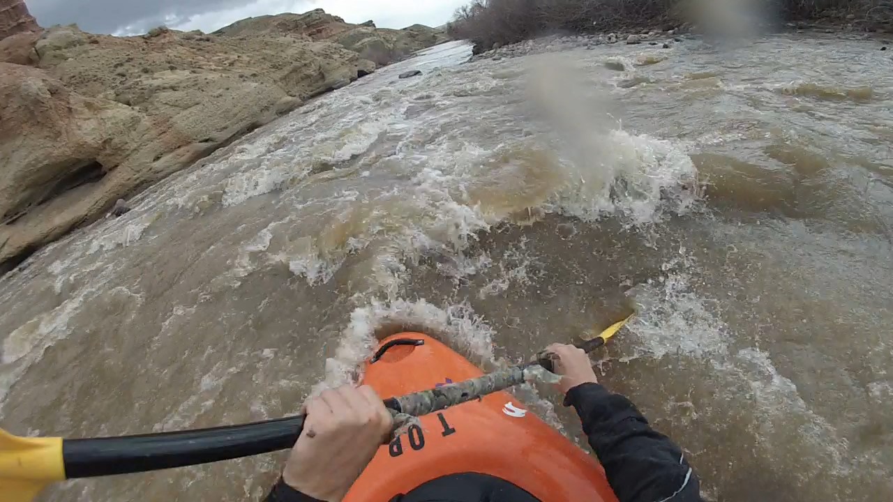
We did the 8.5 mile Fish Canyon run south of Dubois 6/4/2023. This is generally rated a II/III+ run at lower flows but it really veers into IV+ territory at the higher end. We hit it at 3300 on the Red Creek gauge and it was one of the most dangerous and wild stretches we have ever done. We have done a lot of Class IV runs but the sustained nature of the rapids (the nastiest bit was at least 3/4 of a mile) and the inability to self rescue due to the speed and size of the features made this something we are not willing to do again. Please do not attempt unless you are pretty confident in your technical and rescue skills (it is also impossible to scout once you are in it). There's not a lot of beta out there on this section of river and I just wanted to put a general warning out in case anyone wants to give it a go at these higher flows.
Apr 22, 2020
The normal put in location for the Fish Canyon stretch is a fishing access point to the Jakey's Fork on US Highway 26, just west of the Fish Hatchery and Trail Lake roads. Putting in here involves floating down the Jakey's Fork to the Wind River, which requires adequate flows in the Jakey's Fork. Read the sign and map at the parking lot for pedestrian access information if planning to walk down the riverbed (https://wgfd.wyo.gov/accessto/Access/jakeys.asp). Otherwise, you could put in at relatively new fishing access points on the east side of Dubois (near Rodeo Grounds) and float an additional 3 miles. The first take out location is the fishing access point at the bridge on Red Hills Road, but any of the other fishing access points downstream of here can be used as a take-out location. From the Jakey's Fork put-in to the bridge at Red Hills Road is just over 3 river miles. The optimal flow for this stretch, in my opinion, is between 2500 and 4000 cfs because the rapids begin to wash out at higher flows although some large holes form in the canyon. Floating on the Wind River below the confluence with the East Fork, where the Wind River Indian Reservation begins, requires a Tribal fishing license, guide, and/or Tribal Council approval. Contact Wind River Fish and Game for more information on floating the Wind River through the Reservation if interested (flat water): https://www.windriverfishandgame.com/ Hazard note: A large diameter pipe crosses on the bed of the river approximately 1 mile downstream of the Jakey's Fork confluence. This pipe transports water from a ditch across the river, and creates a strainer hazard, particularly at lower flows. The best line is not obvious while floating downstream, but the pipe is generally passable on river-right.
Sep 6, 2017
My wife and I ran the Fish Canyon Section in Aug 2017 at a gauge reading of 650 cfs. At this level the rapids in the 3 mile section we ran were a fun Class 2. We ran the river in a solo open whitewater canoe and an inflatable kayak. There was sufficient water that all the rapids had fluid lines if you picked your routes correctly. There were also a decent number of rapids to make the run worthwhile. We put in at the Painted Hills Fisherman's Access which is on Red Hills Rd. off of Route 26 which is approximately 5 1/2 mile SE of Dubois center (plenty of parking). We took out at the North Parker Fisherman's Access which also had plenty of parking. This section was well upstream of the Native American Reservation so no permission had to be obtained. It is my guess that the river would still be fun with water levels at least 100 cfs less than what we had, although one or two rapids might have scratchy lines. The length of the run could readily be extended if one put in upstream at the Fisherman's Access where Fish Hatchery Rd intersects Rt. 26. This is 3 1/3rd mile downstream of Dubois center. At this access point you would have to launch the boat on Jakey's Fork Stream and paddle/walk your craft down to where it meets the Wind River. This upper section of river appeared to have a couple of Class 3 rapids even at 650 cfs although since we didn't run them I can't be sure of that assessment. One could also extend the trip downstream for several miles and take out immediately before the start of the Native American Reservation. One possible take-out would be where Rt 26 crosses over the Wind River just upstream of where it is joined by the E. Fork of the Wind. There were some visible rapids in this section, that also looked about Class 2 in difficulty.
Apr 23, 2014
April 23, 2014
Ran this section with a buddy yesterday it was about 850-900 cfs at the time. Due to this being on or near the Indian reservation you may need a special reservation fishing permit to even boat this stretch however I did not have one and had no issues boating. Put in and take outs are very hard to figure out but we just used the public fishing access points located all along the stretch except for the upper put in which takes you to the best rapids on the run. To put in at the upper most puttin park at the fishing access at the dubois fish hatchery and float or walk the stream about a half mile and you will flow into the main wind river. Pretty much all class 2 maybe a few class 3 rapids especially if the water is higher. However at 800 cfs the water was all flowing and moving at a good speed several nice fun wave trains and play spots. Tons of eddies to catch. There is probably a range in the river if it gets high enough that it will eather all wash out if there is enough water or become a big water type feel to the run. Respect all private property and on river right is a lot of peoples houses just yards from the river so respect there land to and you should have no problems. Around May is when the snowmelt should start effecting the wind river.
