Piru Creek
4) Lake Piru to Santa Clara River(Lower Piru)
| Difficulty | II+(III) |
| Length | 6.7 mi |
| Avg Gradient | 37 fpm |
| Gauge | Piru Creek Below Santa Felicia Dam Ca |
| Flow Rate as of 1 hour | 21 cfsbelow recommended |
| Reach Info Last Updated | September 15, 2025 |
As of 2020 the best section to boat is reported to be between the upper bridge and the second bridge. The channel is reported to be reasonably clear of brush in this section but filled with brush in the sections above and below. Put in at the first bridge and take out at the second bridge.
Fall Releases: In years when there is enough water in Piru Reservoir, United Water Conservation District has fall releases into the creek to recharge groundwater in the Santa Clara River valley. Releases usually start in early September and extend through mid October. Flows usually start around 400 cfs, then gradually drop to 250 cfs over the course of the release. The actual timing and flows vary from year to year and are not guaranteed.
Dam Put in Access: Boaters seeking access to the put-in site on the District property must make reservations at least 24 hours in advance by sending an email to bernardr@unitedwater.org with your request and contact information. All boaters accessing Piru Creek from the District property must read and sign a waiver form. The form must be signed before access will be given – no exceptions. Access to the upper put in below the dam on District’s property will be limited to Saturdays and Sundays between 9 a.m. and 3 p.m. Vehicles left in the parking area must leave by 4 pm.
For more information, call United Water Conservation District at (805) 525-4431 United Water Conservation District
Warning: Measuring instruments mounted on metal posts have been placed in a number of locations along the creek. These posts may present navigation or broaching hazards. Be on the lookout.
2011 Fall Releases: September 12 to October 27.
2010 Fall Releases: Releases of about 400 cfs are expected to start on September 17. Put in shuttles will sta
...
During fall releases, park vehicles in this large area next to Piru Canyon Road, where a side road drops down to the base of the dam. Look for a sign identifying the parking area. United Water Conservation District will bring vehicles to shuttle you down to the creek. Have all your gear ready to transfer to the shuttle vehicle when you get there.
The shuttle service and access here is only available during the fall release, on Saturdays and Sundays, from 9 am to 3 pm. The parking lot will be closed and locked after 4 pm. This put in is not available at any other time.
This put in is only available during the fall release, on Saturdays and Sundays, from 9 am to 3 pm. United Water Conservation District will shuttle boaters to the creek at those time only. Call United Water Conservation District at (805) 525-4431 to make reservations at least 42 hours in advance.
There is reported to be a good play spot right at the put in.
Expect to deal with lots of brush for a half mile till you reach the spillway channel.
As of 2020, this section is reported to be impenetrable.
The creek enters an section of dangerously thick brush for the next 4/10s of a mile. Though this is the natural channel coming from the base of the dam, it never receives high flows which could clear out the streambed. Most of the year the release is only 8 to 10 cfs which encourages thick brush growth in the channel. With fall release flows, water is flushing through this brush in many areas. The difficulty rating given is not due to rapids but to fast current, sharp turns and dangerous brush.
High winter flows that would normally clean this channel are mostly captured by the reservoir, then diverted over the spillway into the spillway channel 1/4 mile to the west.
It appears that boaters enter Rancho Temascal property as they enter this jungle area.
High flows over the spillway during big winters can keep the channel relatively clear of brush below this confluence. It will be a relief to exit the tangled forest that is the release channel and enter the much more natural high flow channel.
If there have not been any high flows for a few years, the channel will be over grown here as well.
As of 2020, from here to the second bridge is reported to be the only boatable section. The upper and lower sections have too much brush. This put in is available 7 days a week and avoids the brushy jungle below the dam put in.
There is a limited amount of parking along the narrow shoulder of the highway. The highway right of way is reported to be 30 feet on each side of the center line. The property fence is probably on that boundary but then encroaches in up to the edge of the bridge. It is a bit awkward to get around the fence, but it is legal to access the river from the road right of way. Once on the creek, there is a public right of way below the high water mark. The creek drops about 2 or 3 feet on the downstream side of the bridge. At higher flows it must create a dangerous reversal. At 250 cfs, the left channel did not have enough water to scrape through. We got stuck and had to walk (sept 2, 2007). The center opening looked like it had enough water to paddle through. There was a reversal there, but probably not big enough to do anything.
As of 2020, this appears to be the best take out. The brush below this bridge is to thick to paddle through.
Parking and access appears to be similar here to the first bridge. We did see lots of people wading and swimming on Labor Day Sunday. There were no drop offs or other hazards at this bridge.
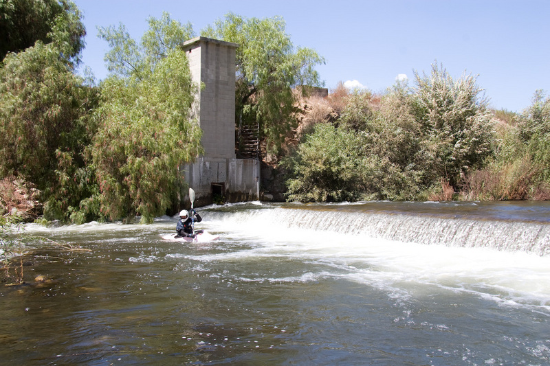
This dam had about a 2 foot drop over most of its width at 250 cfs. (sept 2, 2007) There was a chute on far river right, but it ran into thick hanging branches from a tree. We ran it a few feet out from the right where there was still plenty of water but no branches. The rest of the dam looked shallow enough that we could have scraped and pushed our way over. The reversal across the base of the dam was tiny at 250 cfs, but could become dangerous at some higher flow.
This dam is an abondoned USGS stream gauge with the gauging tower on the river right.
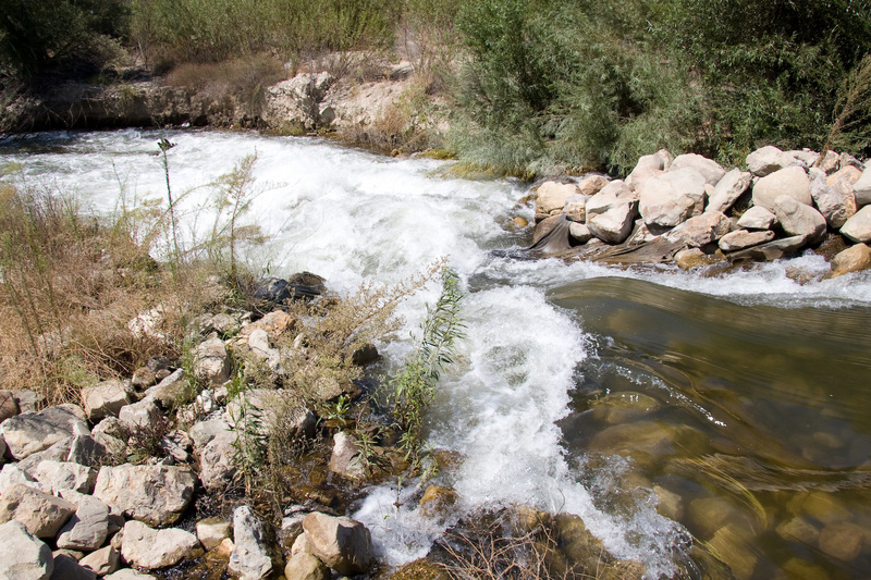
A rock and earth dam divides the channel into a large pool on the left and a steep narrow chute on the right. The chute would be a clean class 3 except for a splat rock in the middle at the bottom. It does not look easy to avoid and there is a stump to the right just below that. It is probably no big deal, but it stands out on a class 2 run. We portaged, but might or might not next time. Other boaters run this drop with no qualms. Any winter that there are high flows, this probably gets washed out and is rebuilt in the summer. So it probably changes completely every few years.
Water is diverted out of the big pool on the left, for the Piru Mutual diversion and the Temescal diversion #2. Elevation is about 708 feet.
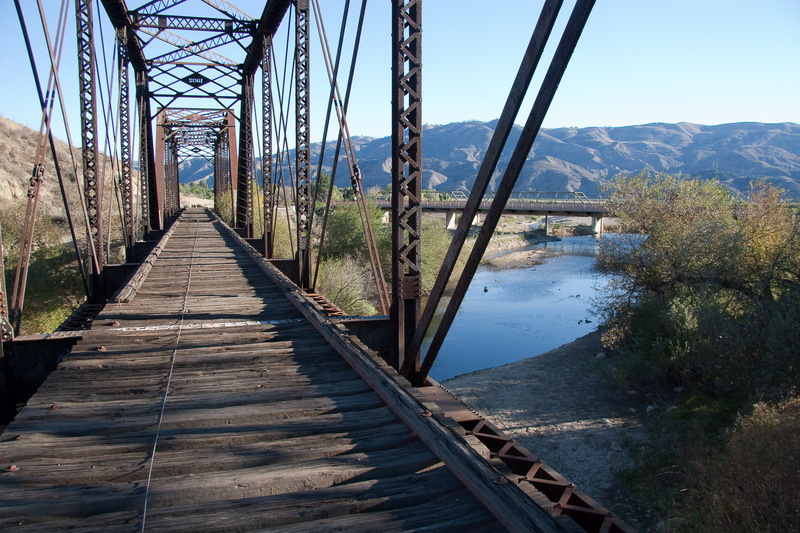
An abandoned railroad bridge marks this park, and marks the transition from the upper section to the more spread out and less interesting section below town. The bridge and park are fairly obvious on the way to the put in. There is plenty of parking there, bathrooms, picnic tables, playgrounds, shade trees and shelters. It is a nice place. Expect lots of families cooling off in the river and using the playgrounds. Elevation is 685 feet.
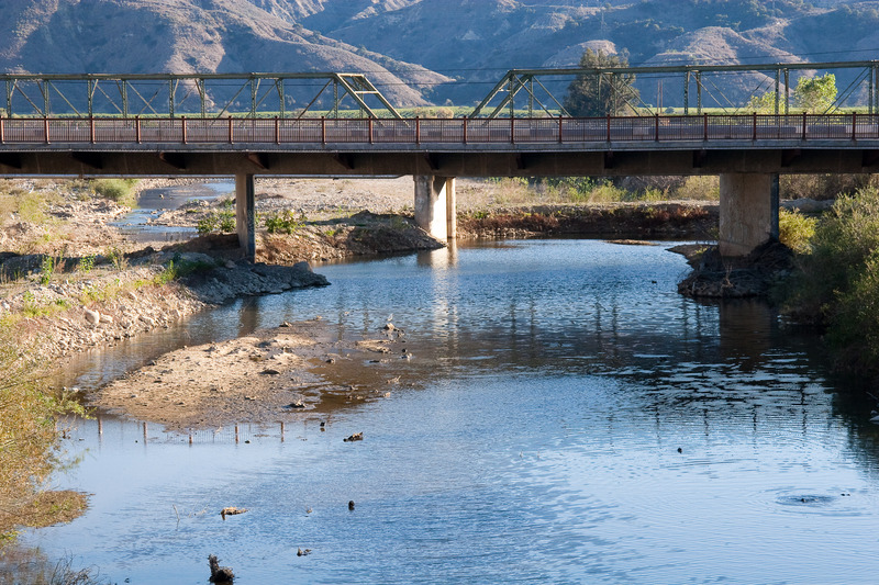
UWCD has built up earth dams under the bridge to divert some of the water through a gate on the right. Boaters can continue down a narrow channel on the left. These berms and channels probably change somewhat whenever they are washed out by winter high flows, then rebuilt afterwards.