Mineral Springs Creek
S.Ravine St. to S.Milwaukee St. (0.5 mile)
| Difficulty | II+ |
| Length | 0.51 mi |
| Avg Gradient | 80 fpm |
| Gauge | Menomonee River at Menomonee Falls, Wi |
| Flow Rate as of 45 minutes | 3 cfsbelow recommended |
| Reach Info Last Updated | April 18, 2026 |
Quick Facts:
Location: SE Wisconsin, just south of downtown Port Washington.
Shuttle Length/DriveTIme: 0.6 miles/3 minutes
Put-in elevation is approximately 640'.
Take-out elevation is approximately 600'.
Thus total elevation change is approximately 40', in just under a half-mile (for an equivalent gradient near 80 FPM!)
IMPORTANT NOTE: Gradient values should always be used for general comparative purposes only! Differences (even up to 15-20% and more) mean very little in the grand scheme of all things whitewater! Far more important (than either gradient or class/rating) are other less-quantifiable 'character factors' such as: (1) continuous versus pool/drop, (2) wide-channel with multiple routes versus narrow channel with essentially one route, (3) straight-shot routes versus complex technical maneuvering-required routes, (4) gradual river banks versus rocky shores or steep-walled gorges, et cetera. Never rely solely on class/rating to decide if you should run a river/rapids!
Drainage area at put-in: 2.75 square miles (Yes, tiny!)
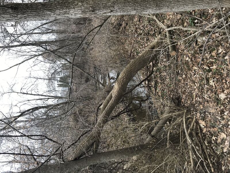
Character: Tiny, intimate, super-micro-creek; twisting, turning, brush dodging, rock slamming, steep banks, ... and virtually guaranteed deadfall and strainer issues.
General Overview
A tiny, intimate 'stupid boater tricks' run, with likely snags, 'clothes-lining' deadfall, and tight maneuvering. With a drainage area of 2-3 square miles, this will require significant rain and will have a very short window of opportunity. That said, high-water debris on numerous occasions suggests that happens at least a few times a year.
Scroll down to the 'River Features' for details why anyone might even look at this stream. In truth, it is little more than a 'fantasy run'.
...To add some length to this really short run, the creek could be theoretically boatable between Sunset Road (CTH.CC) and S.Ravine Street ... were it not for the fact that the banks are significantly wooded and are subject to erosion. There is so much deadfall blocking numerous locations that only a glutton for punishment would ever try!
Access from this location would provide a slightly less busy put-in (than either of the other options, cutting off about 2/3rds of a mile from the upper, or adding about 0.22 mile to the lower).
Unfortunately, major wood precludes passage from here to the next listed access point, our reccommended put-in.
Drainage area at Sunset Road/CTH.CC is 1.42 square miles (as calculated by USGS StreamStats 4.0 Beta software).
At Ravine Street it has almost doubled (to a mere 2.74 square miles).
Park curbside where this little creek crosses S.Ravine St. (near Western Avenue).
There had been a short cement/corrugated iron ledge-drop at this location (as shown in the accompanying photo), with rocks filling the pool, but all of that has been removed, leaving this area flat and calm, eliminating any reason to put-in upstream of this bridge.
The easiest put-in will be on the downstream river-left side of the bridge.
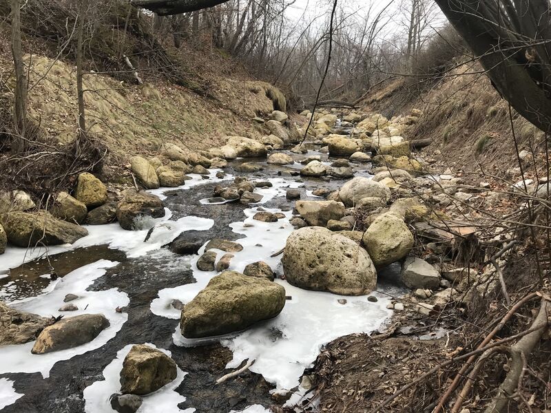
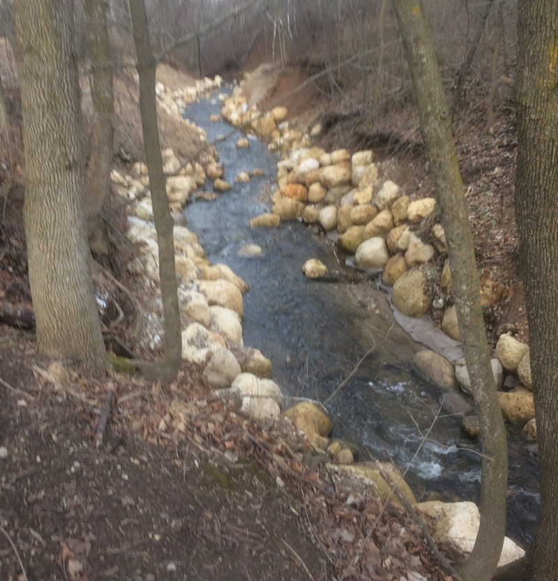
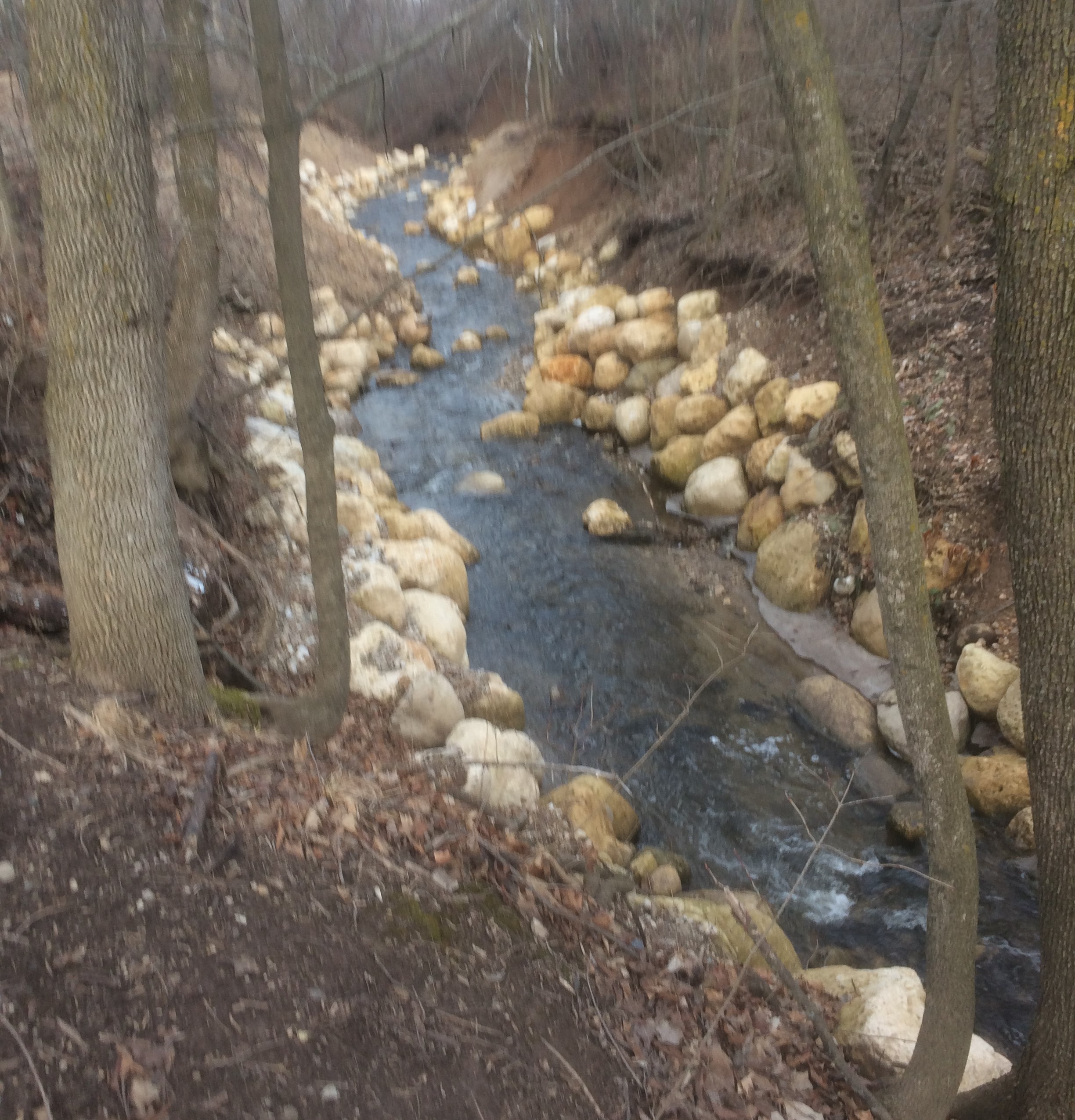
A 5' dam at this location was removed in 2017. Stream banks were sloped back and denuded to facilitate that work. To reduce erosion, large boulders line the bed and banks through the twists and turns. Another project from November 2025 through March 2026, described goals of 'addressing severe erosion, habitat degradation, and infrastructure vulnerability', 're-grading the stream channel, stabilizing eroding banks, and implementing native vegetation plantings', 'outcomes include reduced sedimentation, improved stormwater management, enhanced fish passage, and increased habitat quality for native fish, birds, and wildlife'.
Numerous areas of woody debris were removed. Rocks and logs (secured in place) now break up the flow and armor the bed and banks. Much of the upshore area has sisal matting staked in place to stabilize earth until plants are more established.
All of this results in having this tiny creek the most potentially runnable I've seen it in 25+ years!
The 2017 project ended at this point, and the 2025 project begins here, running to the next road bridge.
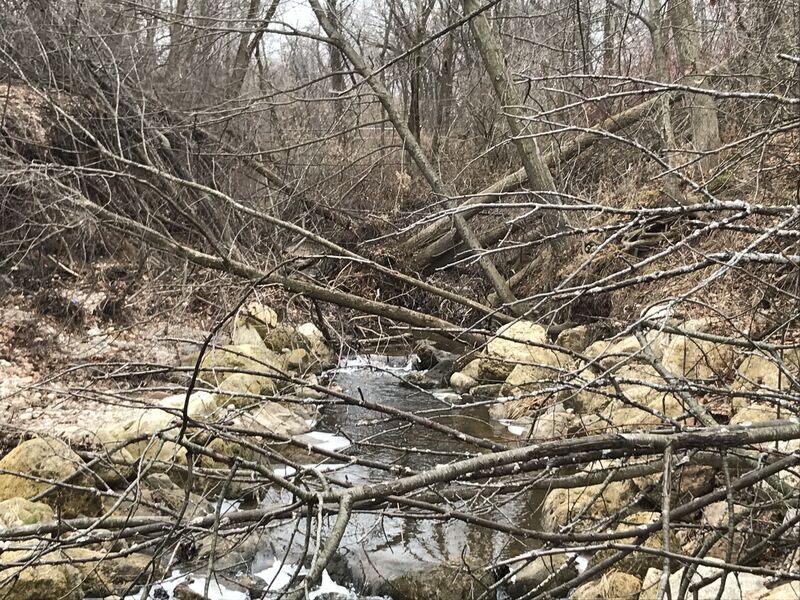
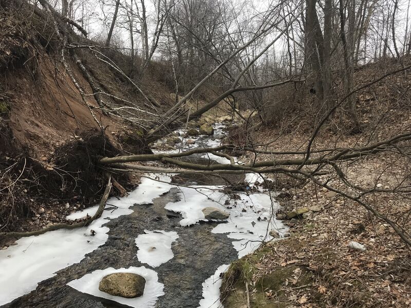
This section should be walked to thoroughly scout the status of this project area (to see what twists and turns remain, and whether wood may have come down and hung up here) before putting on upstream in any watercraft!
The creek bends sharply left/north, to head toward the street crossing.
As the creek approaches the W.Oakland Avenue bridge, a row of cut off wooden posts jut vertically in the streambed (undoubtedly remnants of the supports for a long defunct horse-and-carriage bridge).
This area is very much subject to strainers and snags. While any rapids here may merit no more than class I-II rating, the high potential for snags and difficult maneuvering suggest a much higher skill-level may be required.
Scout upstream (and down) from the Oakland Avenue bridge before putting onto the creek!
(Downstream of the bridge, private properties flank the stream, making it impossible to walk this stretch to scout for blockages).
An old 'plate gauge' (metal strip) is attached to the upstream river-right face of this bridge/culvert. It is visible from the sidewalk, but not easily readable unless you have binoculars with you. (Both shores are private property (upstream and downstream of the bridge), so there is no good way to get down to water level from the sidewalk.) Other than the binoculars method, the only way to get an accurate reading from the gauge will be from your boat as you come downstream.
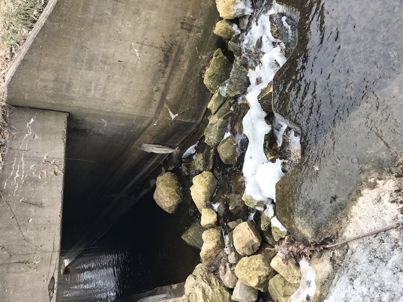
On the downstream edge of S.Division Street, there is a short 'hydrraulic jump' caused by the cement culvert. This may be a fun short 'boof', and might even provide minor play opportunity. (Good luck actually being here at a time which that might happen!)
As soon as you see powerlines overhead (and the power-plant dead ahead) look for a place to exit to river-left. (Exit from the creek may be quite awkward.) Walk through a little bit of woods to the stub end of Milwaukee Avenue.

Downstream of our recommended take-out, the creek approaches the WE Energies Port Washington Powerplant. At times of higher flows, the creek splits here. The historic channel heads left, and is quite narrow and filled with cattails and shrubs, making passage difficult-to-impossible. As the creek passes under the roadway to Coal Dock Park, very low-slung horizontal pipes span the creek at a height which precludes any safe passage.
The second alternative from the split would be to the right. Peak flows will spill over a cement wall into a channel which passes south of the WE Energies powerplant. Railings on that wall preclude dropping into the channel below. Rocky rubble lines the whole channel down to the lake. Having enough water to make this channel anything close to boatable is likely to be far too much water to make the bash-and-crash (down the narrow, strainer-and-sweeper filled main portion of the run) anything close to sane or do-able!
For the above reasons, it is virtually mandatory to exit the creek before this point!
Nov 27, 2017
The 5' dam which had been on this micro-creek has been removed (as of winter, 2016/2017). The (likely to be covered at 'boatable' flows) lower stream banks have been lined with large boulders, with burlap pegged into dirt higher up (to minimize erosion while awaiting vegetation becoming established).
Feb 23, 2017
The 5' dam which had been on this micro-creek has been removed (as of winter, 2016/2017). The (likely to be covered at 'boatable' flows) lower stream banks have been lined with large boulders, with burlap pegged into dirt higher up (to minimize erosion while awaiting vegetation becoming established).
Jan 1, 1900
There is a cement and iron 'ledge' immediately before entering the culvert for S.Ravine Street. Unfortunately, there is a heap of quarried rock in the landing area. Perhaps with enough flow these may be covered, but more likely they will be barely under (or not even covered by) the water, waiting to rake the bottom of your boat.