Deep
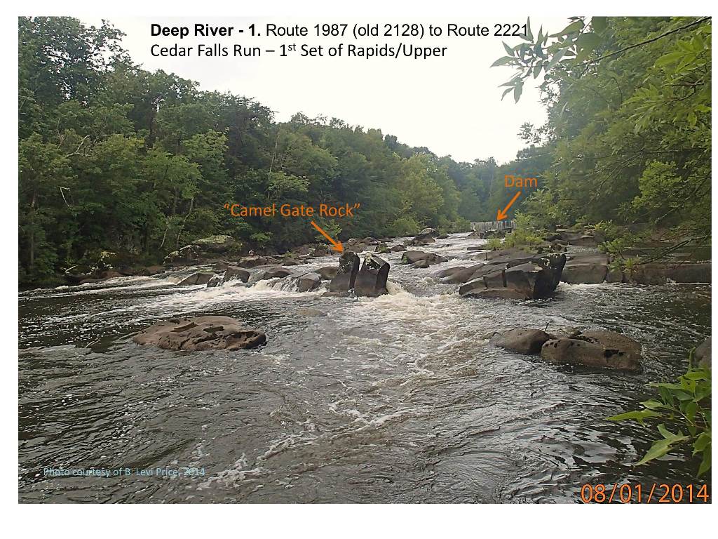
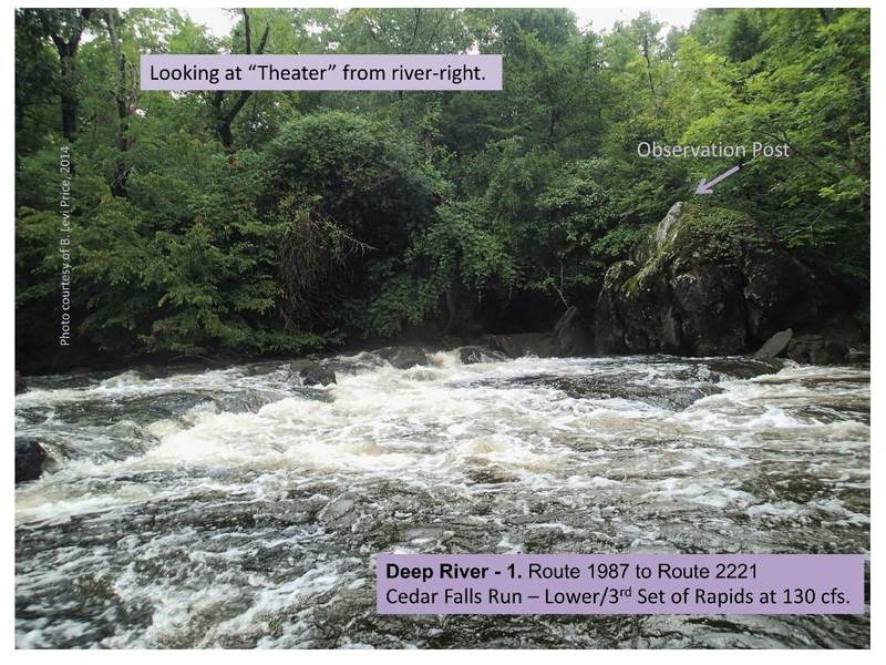
1. Route 1987 (Randleman) to Route 2221 (Cedar Falls)(Randleman to Cedar Falls)
| Difficulty | I-II(III) |
| Length | 8.5 mi |
| Avg Gradient | 25 fpm |
| Gauge | Deep River at Ramseur, Nc |
| Flow Rate as of 47 minutes | 0.75 ftbelow recommended |
| Reach Info Last Updated | January 6, 2016 |
The floatable section of the Deep River begins below Randleman Lake, the river generally a flatwater float, but a few notable rapids exist sporadically. This run previously started just below the low-head dam above Worthville Rd (Route 2128), thus excluding 2.2 miles from the presently described run. To hit every major rapid, a nice ledge is found 300 yards upstream from the Main St. put-in, accessed by walking some foot trails connected to the greenway on the southern side of the river. I have dubbed this bigger rapid 'Peter's Ledge' after the original mill owner. One more ledge rapid just above E. Naomi St, then the paddling gets flat and peaceful again and remains that way until the rapids at Cedar Falls (except for portages around dams....described below).
The Deep River suffers greatly from the stifling number of dams/weirs every few miles. There are three on this section and all are unrunnable to my knowledge. The first is found just upstream from Worthville Road at mile 2.2 and can be portaged on either side. The second is at mile 6.7, found off the end of Franklin Dr. The last dam is at 8.0 miles, found near James Ray Drive in Cedar Falls and should be portaged river left.
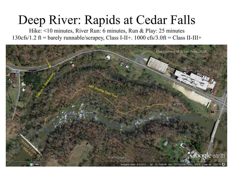
Cedar Falls 'Park n' Run' Whitewater Subsection- This is a micro-run, but it's fairly easy to access, and has some good features for the central piedmont. The run is only about 2000 feet of flow but drops 30 feet during it's course. Customary to 'ledge' rapids, there are often multiple lines with completely different personalities from one side to the other, and dramatic changes as flow increases. This is a great spot for diverse paddling groups, as you can run it multiple times in different ways, do some playing, with good variety depending on river level. Honestly, I'm surprised that more people don't frequent this section (BLP).
Approach: Despite posted signs along most of the riverbank, fishermen and paddlers regularly park on the dirt/g
...
2nd major rapid downstream of Randleman Dam. Found just upstream of put-in. Decent hole for some playboat enders and spins near center left. A very mild surf line is found on river right.
Alternate put-in if you only want to run the 0.5 mile run of rapids in Cedar Falls. Park just past a fenced abandoned retention pond, opposite side of the road from the river OR park at the intersection of Jennings Rd. Put in just to the right of the last purple 'posted' tree and paddle the old mill pond toward the main dam. This is a do-it-yourself access, below a stand of exotic bamboo.

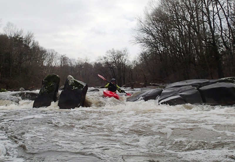
1st major ledge below dam at Cedar Falls. Typically run to the left of the 'gate' rock, but you can run center or river right at most levels. Above 700 cfs/ 3.0' a wave begins to form on river right and Camel Gate proper starts having retentiveness, though snug to the rock. At high levels, the current is fairly pushy and there is the possibility of pinning a boat in the rock sieve.
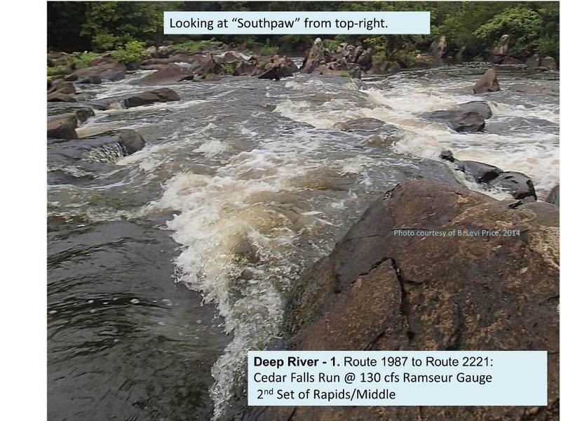
Sorry for the uncreative name. This ledge is typically a mild, almost boring feature with a nice little play wave on river right. However, at higher flows (USGS 3.8' or 1500cfs), the center of this ledge creates a good wave-hole with a decent face and foam-pile. Enders, loops, and cartwheels all possible. Great eddy service on both shoulders.
Most confined rapid at Cedar Falls. Decent playspot forms above 200cfs. Hard to get in the river left spot at times due to pushy currents. Very scrapey run on far right, but a runnable sneak line in higher water. At 1300cfs (3.5') and above, a substantial wave-hole forms 30 yards downstream in the next rapid.
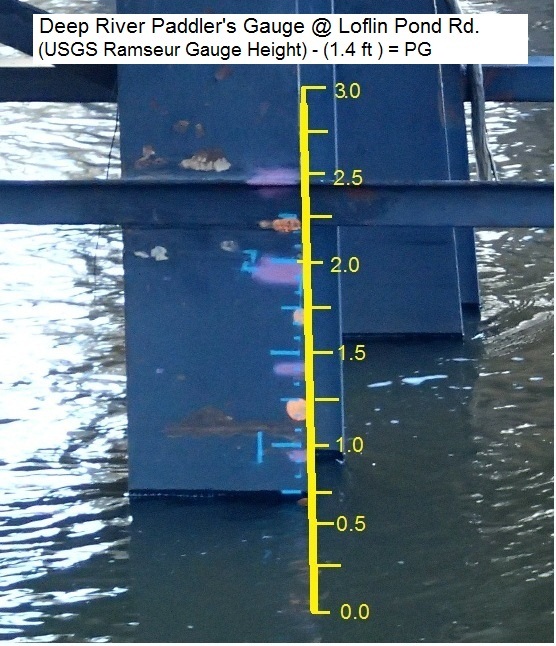
Take out is on River Left, just before or at the bridge. Paddler gauge is rough, painted on bridge support. Anything from 1.0 to 2.0 is usually a good level for Class II / III.
Feb 13, 2023
using the awa reading for the park and huck section level should be 1.8 min. and that starting to scrape. ideal level 2.5
May 23, 2016
went to the 'park and run' section at the end of this run to check it out. Level was 1.5 ft and falling, river was nearly unboatable it was so low.
May 5, 2016
Anything between 1.0 and 2.0 is usually a good level for Class II / III-