Haw
1. Route 1545 (Chicken Bridge) to US Route 15-501 (Bynum)(Upper Haw)
Jul 16, 2025
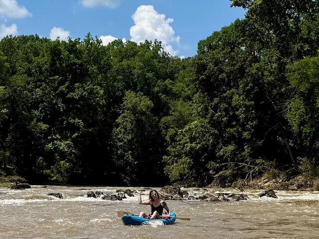
Paddled post flooding event from TS Chantal. We did not use the public put-in for this trip, but note that it has suffered fairly significant damage with multiple (~7+) trees down on the usual path to the usual steep launch. As an alternate, take a right on the path that takes you under the bridge towards the swimming hole/rope swing. The path itself dows have a couple of trees down and got completely washed out before reaching the rope swing but the washout created a steep and less obstructed area to put in. There were no significant log jams or changes to the small rapids as a result of the floods. All strainers on July 13th were easily avoidable. ~1,200 cfs at bynum gauge when we started out and was perfectly runnable by beginners. I paddled a 9'6' Hala Atcha and was joined by a paddler in a Wavesport X and a couple on sit-on-top kayaks. This section is very beginner friendly, although some rocks may cause flips at the lower level. Total time on the water took approximately 3.5 hours, with a couple of short stops to play or chill.
Oct 30, 2018
Upper HAW14,000 cfs 27OCT18 Hala Atcha 9'6
A lot of water moving very fast. Cruising at 5.5 mph without paddling. Some features were bigger, some were washed out. Hell of a fun time though.
Sep 27, 2016
I kayaked this stretch from Chicken bridge on Sunday Sept 25 2016 I believe the water level was just above 3. If it was much less I would have had to drag my kayak over lots of rocks.
I put in under the Chicken bridge. For the first part it was pretty slow moving but scenic.
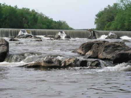
The second part was full of rocks and small rapids and was pretty fast. This was a fast moving and fun section to paddle. After the section of rocks the river became calm and for a few miles I paddled staying to the left as possible for the portage above the dam. I hugged the shore line as I approached the dam and there is a decent muddy take out to the far left. Total trip took about 2.5-3 hrs
The day before I launched from the new kayak landing on old Greensboro hwy and kayaked to the Chicken Bridge. This was about 3 hrs. Very slow moving.
Dec 3, 2014
Ran 11/28/2014 @ ~1800cfs, 5.5ft. in a dagger canoe. Most rock gardens washed out at this level, plenty of water over 'sawtooth ledge'. Trip took 2hrs, lot of steadily moving flatwater.
Have run at 3 ft, (~3-400cfs?) scraped a lot and a lot of maneuvering to get through, but doable.
The bank at the takeout appears to have washed enough to drop some trees across the entrance where the sluice gate is. I didn't like the look of it and took out at a spot about 100 feet farther up, where the trail comes to the bank.
May 27, 2013
Ran it in 2 person Old Town at ~900 cfs. Level seemed pretty much perfect. Most rapids boat scout-able. Had to frantically attain to make another run on the left to center at Sawtooth Ledge (A down tree on left side of the river bend forced us too far river right). Stopping on the rocks at Little Nantahala made for a great middle of the trip lunch/break spot. Not a human was seen until the takeout at the dam. Highly recommend this paddle to anyone interested in getting away from civilization for around 3 hours.
Oct 5, 2012
10-5-2012. Ran Upper and MIddle Haw today at less that 350 cfs. Not too bad, but scarped bottom any times.
Jun 17, 2004
Chicken Bridge got it's name after a truck, loaded with chickens, crashed at the bridge. The surviving chickens hung out at the bridge for several weeks afterward. The Air Force used to use the bridge as a target for mock bombing runs. It was not unusual to have an A-4 Skyhawk or an F-4 Phantom zoom over you at low levels. They made the Air Force stop this practice back in the early 80s.
Oct 16, 2000
This section is known as the Upper Haw or the Chicken Bridge section. It is a good run for the novice at the right level.