Linville River
3. Linville Falls to Lake James (Linville Gorge)

May 18, 2025
Aug 4, 2023
depends who you ask… roughly speaking 2.0’-2.3’ is low (especially past Conley cove), 2.3’-2.6’ is medium fluff, stuff fills in (past Conley getting good), higher than 2.6’ & up is another gray area between good fluff and pushy, 2.8’-3.0’ is pretty stacked and the upper threshold for mere mortals. The Putin is about 6hrs ahead of this gauge at Lake James so today depending on the high country’s summer water table you’d get the gorge probably around 2.45’-2.7’.. perfect
Apr 5, 2017
This is Matt Kuckuk. I was in a group that ran the lower half of the gorge in April 1976, for what we believe was the first descent (exploratory) of that section. The group consisted of me (K1), Fred Young (C1), Mark Hall (C1), Harry House (C2), Bob Obst (C2), Dean Tomko (C1), and Mike Fentress (K1). As I remember we hiked in from the Wiseman Overlook trail and I remember seeing a formation called something like Raven's Rock or Raven's Head from the trail. We ran a lot of Cl 5 through huge boulder fields, no portages. One memorable drop that we scouted and ran, squeezed the water between a big midstream boulder and the right bank, making a sloping falls. Not sure how to line this run up with the descriptions of the sections here, just that we ran out the lower part of the gorge, probably the lower 1/3 to 1/2 after what we heard was an unsuccessful attempt to run the whole gorge by another party.
Feb 2, 2014
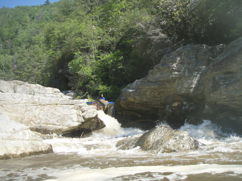
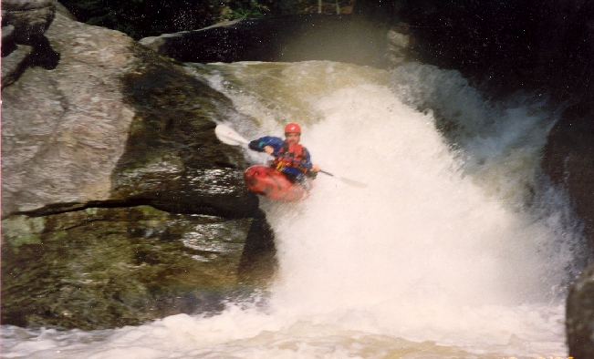
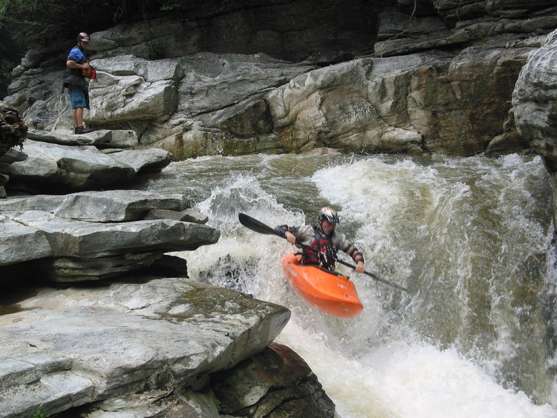
Dennis Huntley in a kayak running the Wall Rapid in Linville Gorge.
Apr 21, 2013
Shot taken of Welcome to Bob's World from the cliff above with Seal Launch Portage far in the background.
Apr 20, 2013
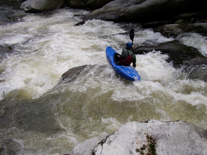
Getting a nice backender out of the bottom hole
Jun 8, 2008
This one is also called China, because you often end up there after you land the drop. Boof left with downstream conviction. Stay off the right.
Jan 18, 2007
From Leland Davis:
Lat / Longitude from TopoZone.
Gradient, mile-by-mile, from Rte. 183 to Rte. 126: 144, 50, 80, 80, 90, 150, 170, 240, 180, 200, 180, 100, 80, 70, 30, 40, 30, and 10 feet in the last 0.55 miles.
That's right, boyzngurls: this baby's got 7 consecutive miles where the 100+ ft/mi gradient doesn't let up! In that stretch of the Linville Gorge, it drops 1220 feet, averaging 174 ft/mile! Ho-lee Fudd! You'd better have your dancin' shoes on!
The above mile-by-mile gradient assumes a putin at Rte. 183. A more realistic putin, as Leland describes below, is below the Falls; that takes 124 feet out of the first mile, leaving 20 feet in the first 0.35 miles. After that, the gradients are pretty much accurate.
Leland Davis' description of the run circa 2001, from his experience:
The putin is at the Falls, although we try to keep a fairly low profile there. The takeout is at the bridge just before the lake. Yes, it is as intense as the (gradient) numbers look. Levels should be 2.0 - 2.5 on the gauge just upstream of the takeout. I did it at 2.0
(Streamkeeper Note: This is the old level, this would be about 2.5 on the new gauge) and that seemed about perfect for me. The first 4 miles is class III with a couple bigger drops, the next 10 miles is class V+ in three gorges. The first reminded me of Vallecito in Colorado. The second gorge was reminiscent of California creeking through granite bedrock, and the third was pure gnarly Linville. After the third gorge there are a couple more miles of class V before the gnar lets up. There were only 1.5 rapids that didn't get run by someone in the group. I did 4 portages. Good fun down there--can't wait to get back!! We had a really strong group of 6 and it took us 7 hours (we did break for lunch). Trip and I are hoping to get it down to 4 hours once we know the lines a little better. Not a good place to get in trouble, though; it's a 2-mile, 2000-foot climb out in the few spots where there are trails instead of cliffs. Scenery is an A+.
Jan 29, 2006
As of 2003, the Kinstler Memorial Highway was a well-maintained dirt road, but a bit slippery after a fresh rain. As noted elsewhere, there are many unrunnable sieves at low water. Low water means much portaging.
Aug 20, 2005
Drop kick me Jesus through the goalposts of life.
Speed is key here.
Keith made this one look easy. Have a look under the left wall before you get involved.
Where does the river go?
Everyone was Kung Fu fighting!
Nice view! Map Falls is the horizon line in the distance.
When I woke up, my head hurt and I couldn't remember a thing.
To a certain group of people this rapid is known as A[CENSORED]m's Barrel Roll Boof, or A[CENSORED]m's Oof.
Someone had to run this one first, and it must have been a project or a real gut check.
Jul 24, 2004
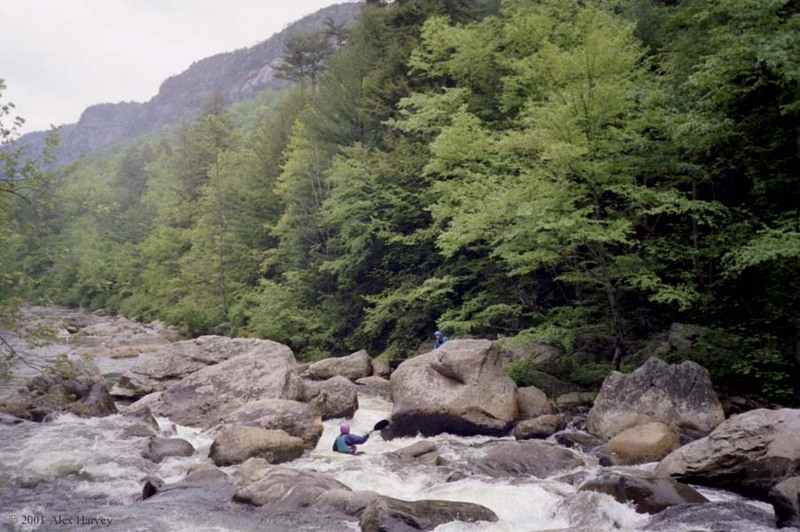
Here's a link to some Linville pics from the late 1980's, and if you scroll down just past the pics (which are from Alex Harvey) there's an article by David Benner in the May 1990 River Runner magazine linked as a pdf file, and a couple videos....
Feb 20, 2004
If you do venture into Linville, I would recommend covering up your body. The Connely Cove trail is lined in places with stinging nettles and the river has some of the most poison ivy I have ever seen. It is mostly avoidable but the scouts at the Clog and at the Wall involve some contact.
I bring soap with me.
Cheers
Sep 23, 2003
The Linville by Chris Young
Jul 15, 2003
Once you've made it around the corner, you're home free.
Jul 4, 2003
Like gas through a funnel or eggs through a hen.
Jun 11, 2003
abit about Linnville (more) New
Forum: BoaterTalk
Re: Anyone ran Linville Gorge, North Carolina? by mootg Apr 20 2001, 0:55 GMT New
Date: Apr 20 2001, 4:33 GMT
From: deluge
Here is some spew.
If I recall correctly AWA did a piece in 1989 (yes'89) about 'the top ten hair runs in the East'. List included: suicide section LRC, Overflow, Watauga, Russel fork, Lower Meadow, Big Sandy, Top&upper Yough(as one), lower Blackwater (but Johnny R had done the upper for 4years), Moose, and yes Linville. This was a year before the Green explosion.
Hell there are races on five of these runs now. Race linville, I'll be walking alot!!!
Clay did it solo on his 2nd run.
Rumor Corran ran everything or didn't get out of his boat.
(smile Corran We are talking aboout you)
They say it is 16 miles long. 2-3 miles flat water in the start and another 3-5miles in the end. Not super steep either and almost pool/drop, but it is a long day if you do the whole thing.
There is a USGS N.C.guage at the takeout.
super low 1.5-1.6
low 1.6-1.75
medium 1.75-2.0
medium high 2.0-2.2
2.2+ watch out
(note have not done above 2.0 but gathered this)
guage being read at the end of the run since if you run shuttle at 7 am and get there 12hours later it ususally is much lower and that is the water you were on.
Jun 11, 2003
Date: Jun 11 2003, 19:14 GMT
From: selmaraid
We got on the upper gorge and it surged close to 3' or so. It was an epic day to say the least. I go back and still can't believe we did it that hight (1.9' being the perfect level). We ran mostly everything except Cathedral (death hole @ high water) and one or two others. Carrying up Connely we ran out of light, our headlamp battery failed, and we resorted to using a roll of TP as a torch. One of my friends dropped his boat and we listened to it bounce to the bottom of the gorge. After the TP torch gave out we abondoned the rest of the boats and resorted to flicking lighters to light the way. We lost the trail and I thought for sure I was going to spend my first night on the river in wet gear. Nobody was very pleased with that thought so luckily we found the trail and made it out at midnight, twelve hours from the time we put on. The next day we hiked in and got the boats and went to the Watauga. I have since avoided the Connely hike out.
Jun 11, 2003
Linville Trip Report (in 80+ degree weather) & new rapid rating system New
Forum: BoaterTalk
Date: Jun 11 2003, 12:33 GMT
From: paddleman m
Yesterday, three of us put in at Conley Cove and ran the 3rd Narrows of Linville out to the lake. I was in my OC1, Dennis in a C1, and Mike in a K1. Dennis has done Linville around 20 times, so he made a good leader to show us the lines.
What a beautiful place! The leaves were on the trees, flowers were out, clear water, beautiful cliffs towering over us and cool looking rapids.
What a wreck I feel today!
First off, the carry in took 50 minutes and was a huge pain carrying a 14 foot canoe. But, Mike was just as slow with his kayak. Some people carry out here, but why they would do that is beyond me.
The river started out with easy eddy hopping until we came to a more significant drop with a big hemlock blocking it. That was our only carry of the day. It was also the beginning of the sieves.
This section of the river has more sieves that the Lower Meadow. In every significant drop, a portion of the river was going under some boulder! I've run much harder rapids on other rivers, but I don't think I've run any rivers that have so many sieves.
As we got to the real rapids, our leader described and rated the rapids for our benefit. As you know, we usually use a I-VI classification. Some rivers, like the Grand Canyon have a 1-10 rating system. Well, apparently Linville has it's own system. The first rapid he described was rated 'Nasty Sonofabitch'. As we moved downstream, we were taught the rest of the rating system. As near as I can tell, here's how it related to the I-VI system:
III = Ain't Shit
IV = Sorry Little Bastard
V = Nasty Sonofabitch
V+ = MF
V++ = Nasty MF
Many of these rapids came with a history of something that happened there, such as 'That's the rock I pulled Bill and his boat out from under' or 'We lost a boat into that seive once' or even 'Stay away from there, I almost died there once'.
The water level when we put on was 1.65. That's as low as I'd ever like to see it. In the narrows, there was enough water, but the wider parts of the river were painfully shallow.
We scouted, set safety as necessary, and videoed a lot, so we were slow. But, even after the 50 minute walk in, the river took us 6 hours to run out. This is not your ordinary run, this is an expedition. And today, I am more sore than I have ever been from a paddling trip. I shall continue a treatment of cold beer application this afternoon. I'm sure that will help.
Apr 24, 2003
the deal with linville...
Forum: BoaterTalk
Date: Apr 24 2003, 22:35 GMT
From: Leland
seems like a lot of folks have been asking about linville lately, and there are some things that need to be cleared up about this run.
i've run a lot of rivers all over north america - many of them cutting edge class V+. LINVILLE IS THE MOST DANGEROUS RIVER I'VE EVER BEEN TO!! it makes the lower meadow look safe. it makes the lower meadow seem like the kiddy pool. there are many blind drops, and every rapid has a horrible undercut or 10. almost every time i've been i've seen some paddler who has been down the raven's fork, high water lower cullasaja, or who knows what other hair run with no problems get HAMMERED AND HAVE A NEAR DEATH EXPERIENCE on linville. someone loses gear on almost every trip because if you let something go, it will go under a rock and not be seen again. these events are not limited to the upper - world class paddlers swim and lose boats on the lower as well.
there are a lot of paddlers out there with the paddling skills to run the rapids on linville. there are few paddlers who have the skill and stamina to scout their way down this run successfully without mishap, and to accurately assess the dangers hidden at every turn. if people keep exploring out there, someone will get killed in short order. don't let it be you. be sure of your skills and ability to handle the sheer number of incredibly dangerous rapids that you will encounter in a day out there.
it's a beautiful place, and an incredible whitewater experience, but it deserves WAY more respect than people seem to be giving it judging by the number of questions i've heard lately about putins and takeouts.
please be careful!
Leland
ps. elvis has now left the soap box.
Oct 15, 1996
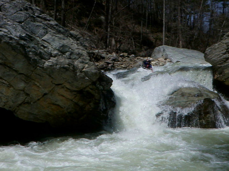
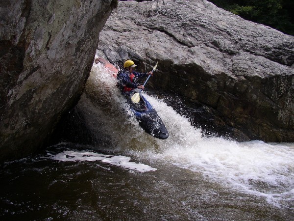
Dave Bruton boofs Cathedral on a crisp, Autumn day.
Jan 1, 1900
RB Binegar on a rapid below Conley Cove, Dennis Huntley holding a rope. This may have been the day I pinned in the slot Dennis is standing over. I was under water for a minute or so before Dennis pulled me and the boat out. I rolled up but Dennis hurt his shoulder.
Jan 1, 1900
The rapid above the big diagonal slide looks pretty suicidal, though I heard someone has run it.
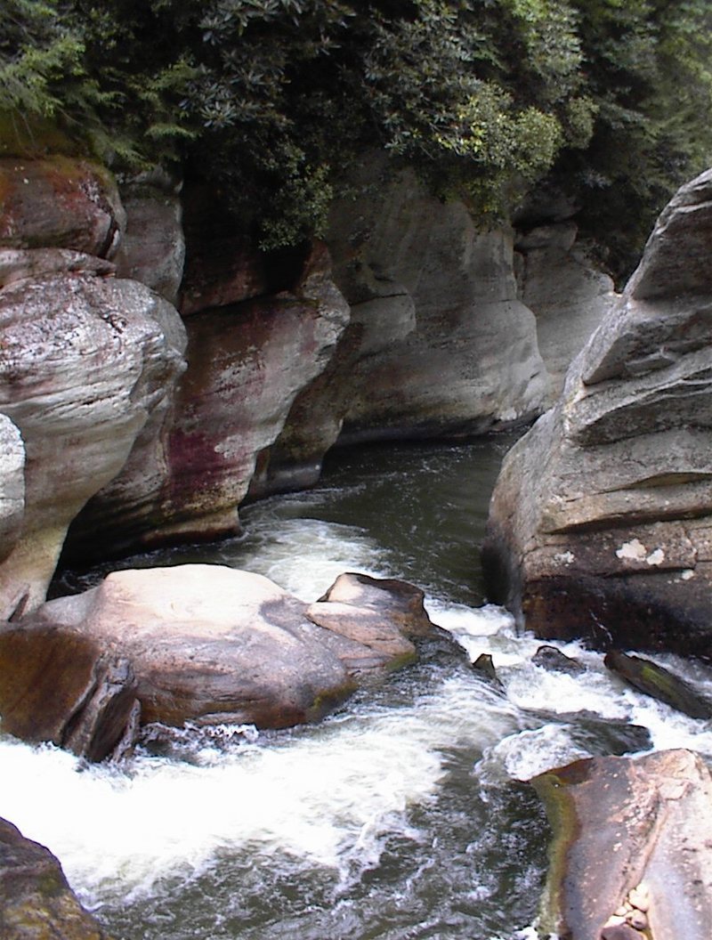
This is looking into the gorge that contains cathedral and homies slot. It is about .65 miles long and super intense with undercuts and sieves everywhere
you look up into this drop when crossing the river to access spence ridge trail
The entrance is pretty crazy looking with tight lines on the left wall. This looks to be the heart of the Linville Gorge.
There are spots like this absolutely everywhere
This is it! This is the most rugged, deep, beautiful and longest wilderness run in the East. Accept no substitutes.
This is the pool right below homies slot, one of the more intimidating rapids on the river.
This drop has alot of power and a sticky hydraulic. Very little water actually exits the boxed in room here, so you gotta keep it together in there.
This is after a recent change to the entrance. Notice the crappy situation that has developed due to the removal of a rock that used to pad out the top of the slab rock. Look at the one below for comparison
The water level stated applies to all the following pictures listed below, untill the last one, which is labeled as such in the description box. The level was noted at the end of the day when the water got to the gauge, not the gauge reading during the run further upstream.
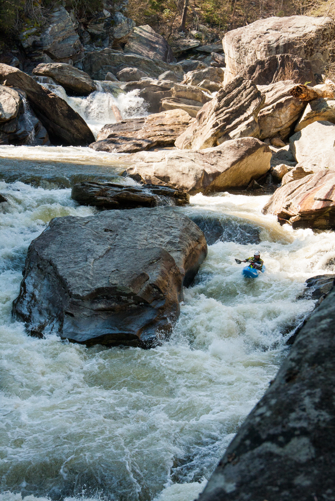
Best putin anywhere
The drop in the picture is a sweet ledge with a sticky pocket against the river right wall.
I say Bob Ross gorge b/c this must run class 5 puts you right into this walled in and calm gorge with overhanging walls and a perfectly framed view of Table Rock. All you can see of the river is the horizon line of Dr. Shoosh below.
This is the zen spot on Linville. This one is the best of many zen spots.
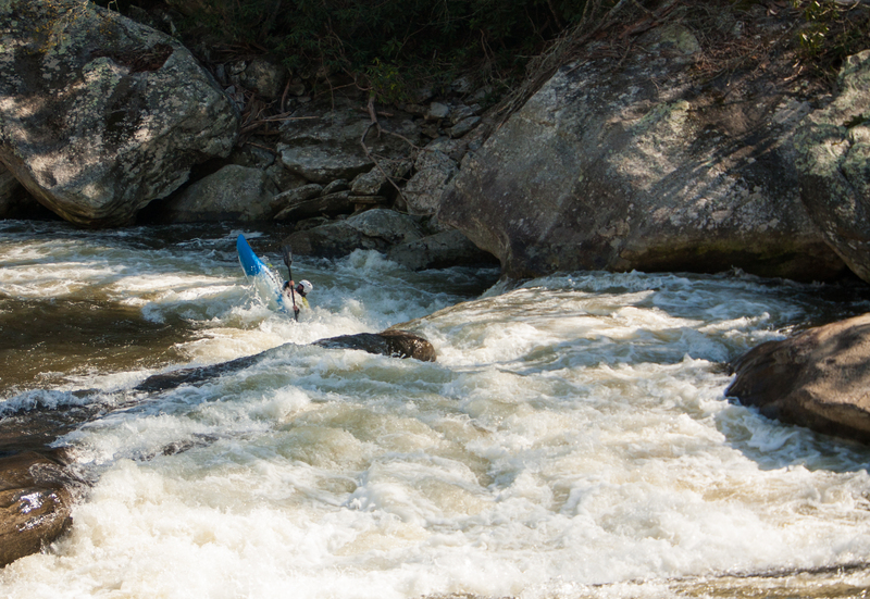
One of the better boofs on the river
You can't see the really bad undercuts here
You can see the scary Arch rapid in the background. This is the scary stretch of Linville.
Its a state of mind.
Hawksbill is seen in the background.
Table Rock is visible in the background.
This is the last of the set of pictures from the level of 2.05 feet in September 2006. The first was labeled 'Getting in at Cave'
picture taken below Wheelie
What a sight for a putin!
The left line is a patience move. Drive the wall late and low.
Shortoff Mountain is on the left.
This is immediately above Linville Falls and is posted with no swimming or entering the water signage.
With decent water it can be run, but otherwise its not a bad idea to slide in below.
Drive on the right, then stomp.
The lower end of this picture is where the horrible pocket is located. Run this ledge far right and take a stroke when you land.
This is the launch that is more vertical and has a rock in the landing area.
The line is down river right usually. No gettin around this one!
Great boof.
The hairiest normally run rapid on the run.
What you see is what you get. Almost always portaged.
Its that good.
He just has finished Arch Nemesis, which is right behind him as he enters double undercut.
Its important to realize that none of the sickness is visible in this shot.
Don't land the first one on your head like Adam did.
It got worse after the floods, but with decent water is not that big of a deal. Just stay on the left side of the right channel.
Headed down the hallway.
The bottom of Cyclops can be seen at the top of the pool in the foreground.
Ahh yes. Cave Falls is the highlight, and leads into the prettiest stretch.
Great rapid.
The pictured line is the more vertical one. There is another center slide and the portage far left.
Down the left, one of the best. This drops the fortunate paddler into the Bob Ross Gorge.
The big horizon line is Dr. Shoosh.
What a feeling.
Good clean fun.
This one is pretty frenetic, but low stress.
You can run left of center, or down the right wall for a nice boof, but a hungry pocket.
Run it twice.
Right below cave diver is hallway, a fantastic long corridor rapid against the left wall. It is easy, but watch out for wood at the bottom. It can render the rapid unrunnable.
Just run it down the middle with a little bit of right drive to avoid any unwanted hits on the left wall.
You might want to check it first, but run down the left channel, staying away from the left wall, though anywhere at the edge of the ledge works.
You can portage on the left and it is a lot easier than the right to get to Cathedral, but on the left you have to run Cathedral blind. The left is better.
A great line on the finale to Cathedral Gorge.
Jan 1, 1900
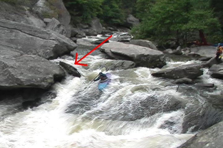
The rock in this picture got moved and no longer deflects current onto the slab Tony is sliding on. The arrow points to the rock. Look in the above picture and notice that it has been moved downstream into the pool below.
Jan 1, 1900
amazing place, please rain.
Jan 1, 1900
The drops are easier than the portages.
Comin' atcha!
Jan 1, 1900
Sweet Boof.