BF
Ben Fleming
Oct 28, 2015
About 1 mile below Camp Hope bridge
| Difficulty | II-III |
| Length | 9 mi |
| Avg Gradient | n/a |
| Gauge | East Fork Pigeon River Near Canton, Nc |
| Flow Rate as of 44 minutes | 36 cfsbelow recommended |
| Reach Info Last Updated | July 8, 2013 |
There are several options:
Possible put-in and takeout points:
Big East Fork Trailhead (big parking lot, put-in upstream of tunnel)
Camp Hope Road (1.7 miles)
Hungry Creek Road (3.7 miles) (park roadside and be low profile)
US 276 Bridge (7 miles) (park roadside upstream and be low profile)
Burnette Cove Road (9.2 miles) (good roadside parking downstream of bridge along US 276)
Gradient:
115
1st mile
80
2nd mile
55
3rd mile
80
4th mile
60
5th mile
50
6th mile
40
7th mile
50
8th mile
40
9th mile
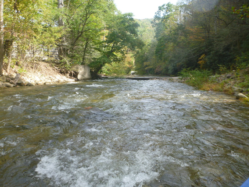
If you put-in at the Big East Fork Trailhead at US276, there is a Class III+ rapid just downstream of the tunnel the river uses to pass under the road. Expect lots of Class II+ and III to follow. There is a fair amount of wood and at low water there are a few low water bridges to contend with. We recently did this when the East Fork USGS gauge was at ~950 cfs and it was a continuous Class III hoot full of waves and playholes. Awesome water quality and some good views of the surrounding mountains and hills. The Big East Fork gauge at te put-in was surging between 2 and 2.5 feet. Downstream at the US276 bridge in the valley, the paddlers' gauge was ~1.75 feet. At the downstream bridge piling at the takeout at Burnette Cove Road, it read 2 feet. wouldn't hesitate to do this run again at a similar level - it was a bunch of fun!
The below account is of a much lower run.
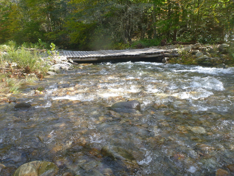
A shorter run (~7.3 miles) is Camp Hope Rd bridge to Burnette Cove Rd bridge with convenient take-out parking. This was a 3 hour run with no stopping except for the 3 mandatory portages. The first portage is a low bridge ~3/4mile below Camp Hope bridge. At 160cfs this bridge was ~18' above stream surface. The second low bridge portage is another 1/4 to 1/2 mile down. This bridge is right at the stream surface @ 160cfs. The l
...Mar 3, 2019
We definitely need to update the flow range on this run. If you're putting in at the trailhead then 500 is a good minimum flow which is around 1'6' on the tunnel gauge. you can go lower, but it gets really boney. Look for 2' or more at the tunnel and consider hiking up the trail on the south side of the creek 1/4 mile to add a couple of fun class 3s. From Camp Hope you could go a little lower than 500, maybe you could go down to 350 as mentioned below. I think at 150, you would be dragging the boat over rocks for most of the run.
Jun 7, 2018
Ran on 6/6/2018 at ~385 cfs. The bridge gauge at Big East Fork Trailhead was 1.3ft and looked too low to put on there. I had scouted this section the week prior and the bridge gauge was surging between 2.0 and 2.5ft which looked like a great low side of medium level. Hiking up on river left to put on would definitely be worth doing at that or higher flows.
Reading past reports and recommendations on lower flows, we decided to put on at Camp Hope rd. You can scout a lot of the river from Hwy. 276, which parallels the river. Looked super low at ~385cfs so we decided to just take out in the town of Cruso at the bridge across from the volunteer fire department in case it was a scrape-fest. Be courteous and low-key with your parking decisions here.
Immediately after putting on, we were amazed at the water quality. Crystal clear and you could see the bottom of the 8ft deep pools. Great scenery and the river definitely has it's own character. We encountered wood fairly quickly downstream at an island- both channels were blocked. Then we portaged two other places with wood, as well as the two low water bridges. We could easily see them coming, but definitely good to have them on your radar.
This wasn't a horrible first-time-down level, but we honestly couldn't see running it as low as 150cfs, even starting at Camp Hope. We wouldn't recommend going any lower than 350cfs. Maybe the river turns into one small channel at 150cfs? We think the recommended minimum should be raised.
Overall, a great day with lots of fun, fairly continuous, shallow Class II. Great eddy service. . Just keep an eye out for wood. the 3.1 mile paddle took us 1.5 hours.
At ~385 cfs, the bridge gauge at Burnette Cove Rd read 0.8ft.(Our original planned take-out).
In summary, and as mentioned before, I'd love to get back on this at 2-2.5 ft, or 700-800 cfs, for a great class II-III run.