Trip Reports
Log in to add a reportAB
Ashley Brennan
Mar 3, 2019
We definitely need to update the flow range on this run. If you're putting in at the trailhead then 500 is a good minimum flow which is around 1'6' on the tunnel gauge. you can go lower, but it gets really boney. Look for 2' or more at the tunnel and consider hiking up the trail on the south side of the creek 1/4 mile to add a couple of fun class 3s. From Camp Hope you could go a little lower than 500, maybe you could go down to 350 as mentioned below. I think at 150, you would be dragging the boat over rocks for most of the run.
DG
Devin Gentry
Jun 7, 2018
Ran on 6/6/2018 at ~385 cfs. The bridge gauge at Big East Fork Trailhead was 1.3ft and looked too low to put on there. I had scouted this section the week prior and the bridge gauge was surging between 2.0 and 2.5ft which looked like a great low side of medium level. Hiking up on river left to put on would definitely be worth doing at that or higher flows.
Reading past reports and recommendations on lower flows, we decided to put on at Camp Hope rd. You can scout a lot of the river from Hwy. 276, which parallels the river. Looked super low at ~385cfs so we decided to just take out in the town of Cruso at the bridge across from the volunteer fire department in case it was a scrape-fest. Be courteous and low-key with your parking decisions here.
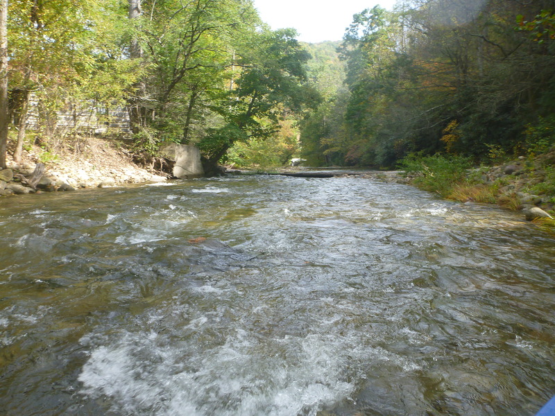
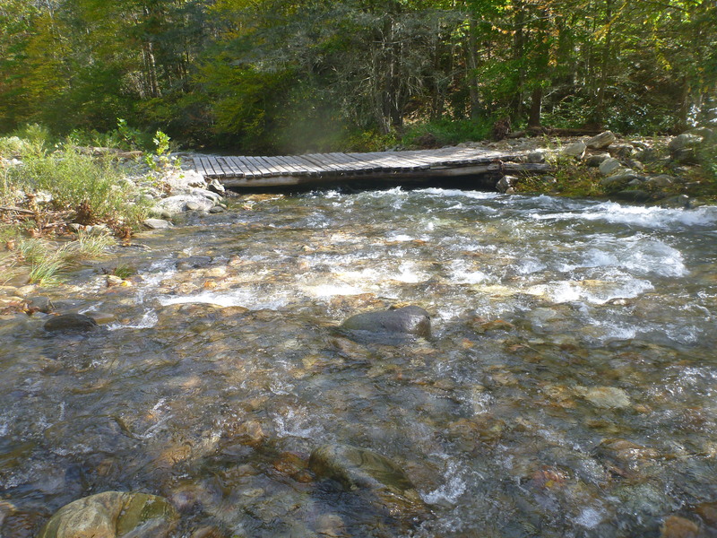
Immediately after putting on, we were amazed at the water quality. Crystal clear and you could see the bottom of the 8ft deep pools. Great scenery and the river definitely has it's own character. We encountered wood fairly quickly downstream at an island- both channels were blocked. Then we portaged two other places with wood, as well as the two low water bridges. We could easily see them coming, but definitely good to have them on your radar.
This wasn't a horrible first-time-down level, but we honestly couldn't see running it as low as 150cfs, even starting at Camp Hope. We wouldn't recommend going any lower than 350cfs. Maybe the river turns into one small channel at 150cfs? We think the recommended minimum should be raised.
Overall, a great day with lots of fun, fairly continuous, shallow Class II. Great eddy service. . Just keep an eye out for wood. the 3.1 mile paddle took us 1.5 hours.
At ~385 cfs, the bridge gauge at Burnette Cove Rd read 0.8ft.(Our original planned take-out).
In summary, and as mentioned before, I'd love to get back on this at 2-2.5 ft, or 700-800 cfs, for a great class II-III run.
BF
Ben Fleming
Oct 28, 2015
About 1 mile below Camp Hope bridge
BF
Ben Fleming
Oct 28, 2015
Below Camp Hope bridge
GM
Gary Mitchell
Apr 25, 2011
When putting in at the trail head look for at least 400 cfs
GM
Gary Mitchell
Feb 7, 2011
Using gage USGS 03456500 the minimum is 150 cfs
RC
royce cowan
Mar 14, 2010
Ran this a while back and found that it is actually quite nice. Very close to the Waynesville/Canton NC area. The put in for us was at the take out for the upper BIG East Fork. You can add on some extra fun to the class III stretch by either hiking up the river right or left hand trails. Their are trails on both sides of the creek. If you don't feel like doing this just put on and float through the tunnel running over the creek.
I found that the upper BIG East Fork has to be running at a minimum in order to make this run any fun. You could certainly do it higher but I sure wouldn't do it any lower.
The run starts off with the most difficult rapid on the whole stretch. It is a 'S' curve boulder drop rapid that you might assosiate with a rapid on the Little in the GSMNP. If you have some trouble with this rapid don't get discouraged, it's the hardest on the entire stretch. Next you will come to an island go left to avoid the wood as of Fall 2009. That side has less water but no wood, so it is best. Over the next mile or so you will come to several more larger characteristic rapids amongst the flurry of smaller ones. Its enough to keep you entertained.
The larger drops can all be boat scouted and are all easy moves. The main thing to worry about on this stretch is wood and a low water bridge. The wood can be walked without much trouble and the low water bridge can be avoided with ease at lower water levels. It comes up when you start to get into some farm land. I'm sure that it would create a obvious rapid at higher levels and it would also prove to be quite DANGEROUS, (Peligro, Peligro). Just go at a lower flow your first time down and figure out where the thing is. The bridge wouldn't allow a person to swim under it and it is angled at a way that would let someone in but not out! High on the upsteam side low on the downstream side. However there is a pool above it and we didn't have any trouble with it.
Once you get past the low water bridge the creek continues with plenty of fun class II and III rapids and a section of ledge holes that can be seen from the HWY. The take out is the white church at the bottom of the mountain on river left. You can park right beside the creek (two car pull out) or you can park at the much larger white church a few hundred yards further down stream and take out here.
All-in-all good class III fun that doesn't require you to drive all the way out to the NOC for. Biggest issue is having good judgment about obvious things. Like watching for wood, the bridge, and staying off privet property. Hope you have fun on this one it is well worth going to. Royce
CG
Chris Gorman
Jan 1, 1900
1