Rocky Broad
2. Lower, Along Route 64/74 to Lake Lure at Chimney Rock
May 7, 2025
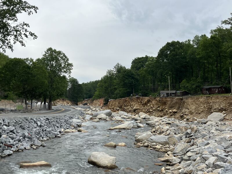
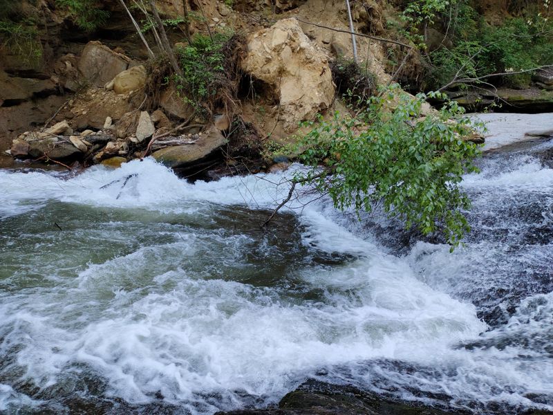
American Whitewater and some partners attended a site visit to the Rocky Broad hosted by NCDOT. It was a sobering visit, with so much hurricane damage to infrastructure, people's homes and businesses, and of course the river. We learned about DOT's plans to rebuild the roads in the gorge. There are some sections of the river that appear to still have good whitewater, much of the river was diminished in quality by the flood, and a lot more of the river has been essentially channelized and simplified by NCDOT to accomodate their temporary road, and the permanent road. The temporary road will ultimately be removed, and the river roughly put back in some kind of shape, which may be followed by 'restoration' by the Army Corps. American Whitewater is advocating for restoration of the river during and immediately following the construction project. The river should be restored to a reasonably safe run of similar difficulty as before.
Maybe it goes without saying, but all of the rapids appear to be totally different.
May 3, 2022
Dec 23, 2018
Dwight seal launching the portage of Walker Falls
Mar 29, 2013
PLEASE NOTE: I had the level very,
very wrong in my long trip report. It was
3.78 on the bridge gauge, NOT 4.78,
which would make a world of
difference on either the Upper or the
Lower! The online gauge said 4.4.
Dec 2, 2009
Here you can see the rapid named A-Frame and the reason for its name. The river was running at 3.9 Feet in this photo. A very manageable drop at this level.
Dec 2, 2009
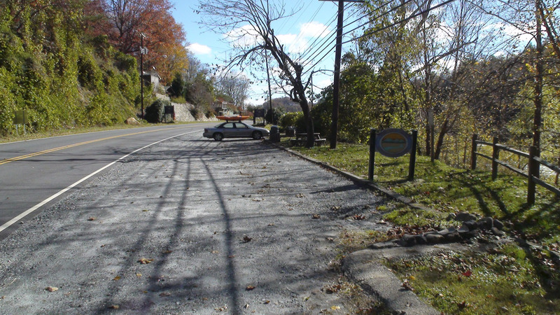
A shot of the public park that is the takeout for the Lower Rocky Broad. Parking here is legal, and likely the best bet for boating access.
Dec 2, 2009
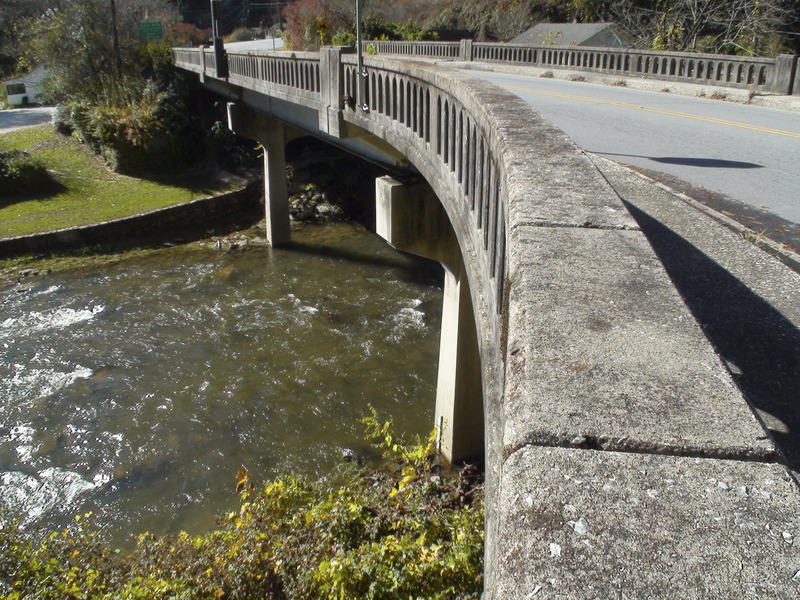
Here in this photo you can see the Rt. 64 bridge (right where it meets Rt. 74) and the Rocky Broad bridge gauge at the bottom of the closest bridge support.
Dec 2, 2009
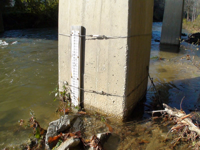
Here you can see a close up shot of the Rocky Broad bridge gauge. In this photo it's reading about 3.9 feet. This gauge is found on the bridge at the intersection of Rt. 64 and Rt. 74 in Chimney Rock, NC.
Nov 18, 2009
The usgs gage Cove Ck near Lake Lure should be a gage of interest. The cfs/sq. mi ratios are the same as the Rocky Broad according to usgs archival data. Furthermore the Cove Ck gage adjoins the Rocky Broad and has the same drainage basin size of the lower Rocky Broad or about 79 sq. mi. with and average output of about 139 cfs. The upper Rocky Broad drainage is much smaller or about 40 sq. mi.. 200 cfs for the lower RB and 300 for upper should work. It is no more of a leap to use Cove Ck for the Rocky Broad as it is the use Ivy River gage for Big Laurel Ck.
Apr 26, 2005
HEADS UP!
Not sure of what they are planning to do long term yet. But the access to the river has been cut off at several spots. There is a temporary bridge that is bad news. What may be worse however is that they have erected a fence on river left keeping people from accessing the river at 'The Gauntlet' and 'Franks/Redneck Falls'. Redneck Falls is often portaged even when there is enough water. At lower flows, it is a mandatory portage/seal launch. If their plan is to make this area a private access point for the landowner. (Already no trespassing signs) There will no longer be any place to scout these rapids, let alone portage.
To anyone paddling The Lower Rocky Broad. Remain conscious of the fact that our access here is already limited. Please be extra considerate to the folks that live over there. Do not argue with the locals nor do anything to provoke the people of Chimney Rock into developing a bad taste for kayakers. I paddle there several times a month and never have any trouble. I'm trying to find out what the ____ is going on with these new developers. I wrote AW about this and I'm sure it will get worked out. 'IF' that is, nobody screws it up before we get to the truth of the matter. Get out and go creeking.
Peace,
JAH WILL
Feb 7, 2005
The new pics are good, a couple of things. redneck falls or franks as we call it is super shity. portage on river right and seal launch off the biggest boulder there, It's way more fun than scraping down the drop. Also the real estate office near the put-in is super cool, the nice folks there are letting my buddies and I put in on their property. Change and everything else discretly, and still park in the pictured lot, but you can put-in there, just be super cool, clean and well mannered. I know Kayakers are already clean cut and all that, just got to be careful.haha, have fun out there!! it's a fun place!
Dec 27, 2004
Gauge on bridge over Lower Rocky Broad
Gauge Reads Approx. -.4 to -.6
Lower Than Online Gauge
Slide. Work your way to the right.
Piton rock has been moved away.
Major Rapid before Redneck Falls.
Work your way down the center.
Avoid the holes and piton rock at end.
Line is where the log is jammed in. I ran line a bottom of picture. Landed on a pile of rocks.
1st Boof run right down the center. Hit eddy to set up for next Boof 2.
Boof 2. Try to hit fingertip for a clean Boof.
Neat little slot move. Start left hit tongue w/Right angle and have speed. Get ready for ender and a good brace. Try to hit eddy on right to set up next rapid.
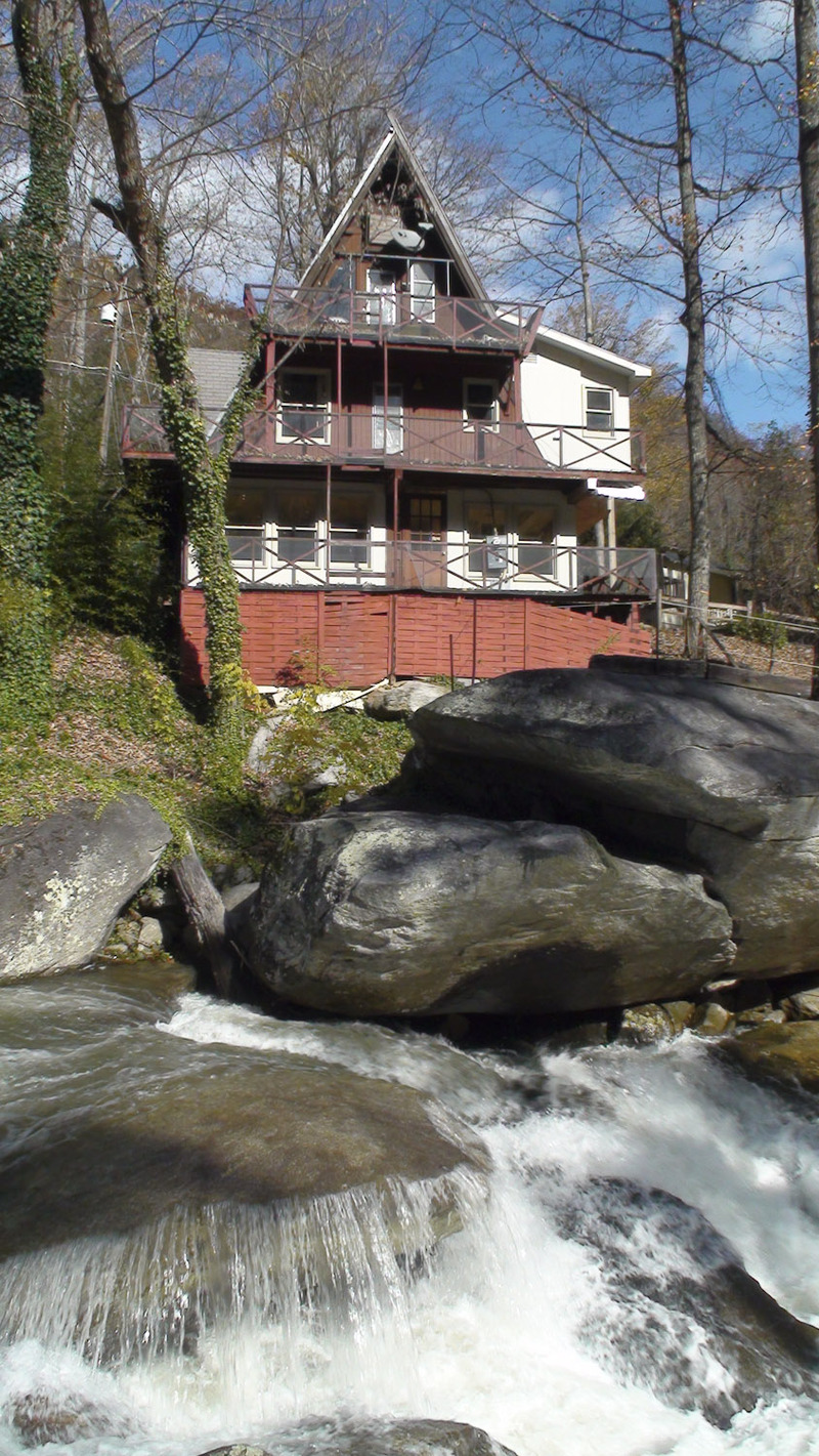
You'll see an A-Frame house hanging over river. Scout on left. Watch for logs. Stay left hit cool boof. Eddies around. You'll be going under rock hanging over river. Rock pile at bottom.
Last major rapid on river. You'll see a big yellow house on left. Start on river right, hit boof. Punch holes, work your way to the left. Watch out for sticky hole at bottom.
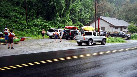
Put in for Lower Rocky Broad. This is looking towards Hwy 64 bridge over Rocky Broad. Post office is on the right. Gravel area is where to park. Private property to get to river when you cross the road. Please be aware of this.
Take out will be on river left. This is looking upstream. Nice open grassy area. Public area to park. Picnic tables.
Oct 5, 2004
From Canoeman on Boatertalk:
My first time on the Rocky Broad! (TR, very long.) New
Forum: BoaterTalk
Date: Oct 04 2004, 17:30 GMT
From: canoeman
Fortunate as I am to work in Hendersonville, N.C., center of the Southeastern paddling universe, there are two runs within 20 minutes of my office that I have avoided. One is the Narrows, which I still don't have any plans to run. The other was, until yesterday, the Rocky Broad.
Actually, the RB has been on my to-do list for years, along with the Watauga. And as a new dad of a baby girl, now a toddler, close-to-home runs are at a premium for me. So in addition to my favorite creek, the North Fork of the French Broad, I have started looking at the West Fork and the Upper Rocky Broad.
Unfortunately, the Upper was too low to run this weekend. But I got over the mental hump about running the Lower. So I called my friend Will (Slave2H2O) and asked him if he would be willing to lead a few newbies down. That would be me and my friend Stephen, a C-boater, and another very hard core open boater I have recently started paddling with, Pat.
Thanks to Frances, Ivan and Jeanne, I have gotten in a half dozen runs on the North Fork in September in both canoe and C-1 and was primed for something new. Also I ran the Upper Davidson earlier in the month with my friend Doug Bonnoitt. When Doug said he had done the Rocky Broad three or four times and loved it, I thought, that's it
Sep 6, 2004
Will Hanna And I checked out the Rocky Broad one day in the spring of 04'. The Internet gauge, (http://www.afws.net/data/nc/henderson.htm) read 4.0 on the Bat Cave Gauge. When we got there the bridge gauge read 3.6 I'd say this is the minimum. It was very low, but you could run all of the rapids but one. Put in at or below the bridge in Bat Cave and go down as far as you want. Will and I did one section of about a mile I think, and just kept hiking back up the road to the top. Close to the start there is a drop that ends with a monster tree blocking the whole river, there is no way to get around it in a boat, but once you go over the lip of the drop you'll know you need to to get to the bank before the log, which is possible, you can still run the drop, just know that you need to be aware. A little ways down there is a slide that has a bir rock in the middle, then more fun slots and drops. It's all super technical, and tons of sieves. the last rapid of the section we ran was the biggest, it was the steepest drop of the run, scout on the left. The drop below this slide/drop thing was too low to run. Good luck, hopefully I can get back to have a more in depth report with pics.
Jun 10, 2003
from RBP:
Search Result 3
From: Chris Bell (bell@unca.edu)
Subject: Re: Flood Hits Rocky Broad
View: Complete Thread (3 articles)
Original Format
Newsgroups: rec.boats.paddle
Date: 1996/09/06
Chris Bell wrote:
>
> A friend called me moments ago to tell me that the
> 11 inches of rain (yes, that's eleven inches) the
> Rocky Broad (NC) basin received in 3 hours last
> night (yes, that's three hours) wiped out at least
> one of its bridges (the one to the campground on
> river right with the nice slot move on river
> left above it). Part of the road is reported to
> be washed out as well. John is on his way to
> check out the damage first hand. Oh, and last
> night's rain is not Fran-related -- the hurricane
> isn't expected to reach the coast until late
> tonight and we in the mountains won't feel its
> effects until tomorrow afternoon at the earliest.
> YOW! Don't expect me on the Gauley this weekend...
John last night and the Asheville-Citizen Times this
morning confirmed all of the above and more. Eleven
inches of rain did fall in three hours, seventeen
inches in 24. Other than the volume, the rainfall
was pretty typical for the WNC mountains this time
of year in that places 30 minutes from ground zero
received no rain at all!
At least one bridge was washed out, a restaurant
was washed into the river and was last seen in Lake
Lure, mudslides have closed the road between Bat
Cave and Chimney Rock, numerous homes have been
flooded and some knocked off their foundations,
etc., etc.
John tried to run the river yesterday afternoon
(it had dropped to a very reasonable but pushy
+11 inches) but was 'ordered off by a bunch of
rednecks in pickup trucks yelling something
about the river being closed and paddlers being
subject to arrest.' Given that campers were
still stranded at the time and the 'rednecks'
were no doubt the local rescue crew, I think
it wise that John and his boating buddy didn't
press the issue. Most local rescue squads are
next to useless in river rescue situations
(a problem Slim Ray is working to address in
our area) and it is incredibly unlikely that
John would have gotten into a situation
requiring their 'services,' but they didn't
know that and they do know enough to know that
swiftwater rescues are extremely dangerous
(even more so for them!). My sympathy is
with the rescue squad. It's not like the
Rocky Broad won't be running at + 11 again in
the near future...
Oh, and Fran has missed us entirely, so maybe
you will catch me on the Gauley this weekend!
-- Chris
Jun 9, 2003
sept 1996 was the flood that last changed the riverbed.
Jun 9, 2003
flood warning update
Jun 8, 2003
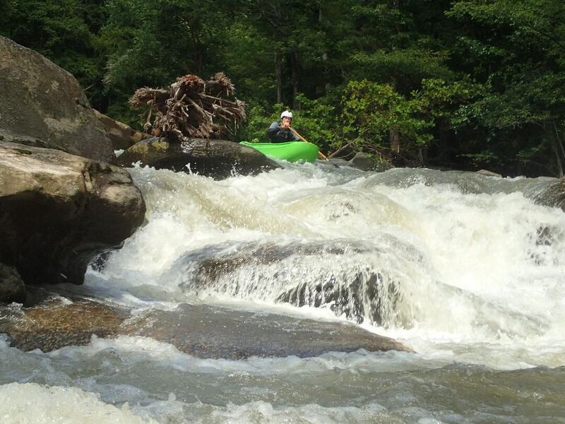
Big boulder rapids. With really big boulders. Underwent major changes during a 1996 floods. Some very hard moves in the rapids. At higher flows it starts looking like the NF Payette. Big, steep and continuous. A swim could really suck, and you would probably not get your boat back until it hit the lake.
Jan 1, 1900
Also called The Gauntlet
Jan 1, 1900
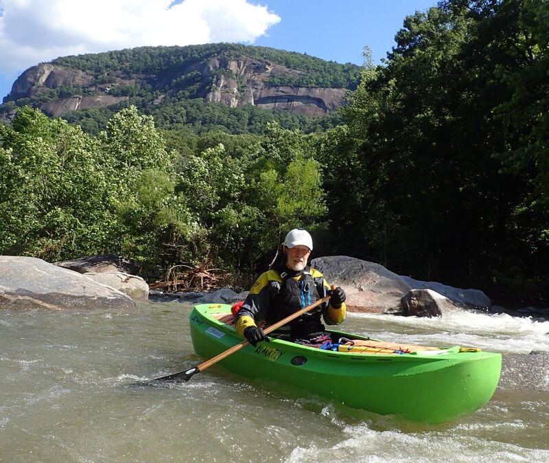
Chimney Rock seen in background.
Jan 1, 1900
I may be wrong about the name of rapid, Oh well.
Jan 1, 1900
Redneck Falls is actually the politically correct name for the falls. It was originally named 'mouth-breathing-inbread-white-trash-redneck falls.'
Put-In parking is at a premium on the Lower RB. Don't park at the local business or near the bridge. When the RB is running, its easy to thumb a ride or just walk back up the road to your car. Remember, you are in the middle of town, so be polite and discrete.
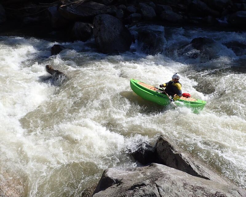
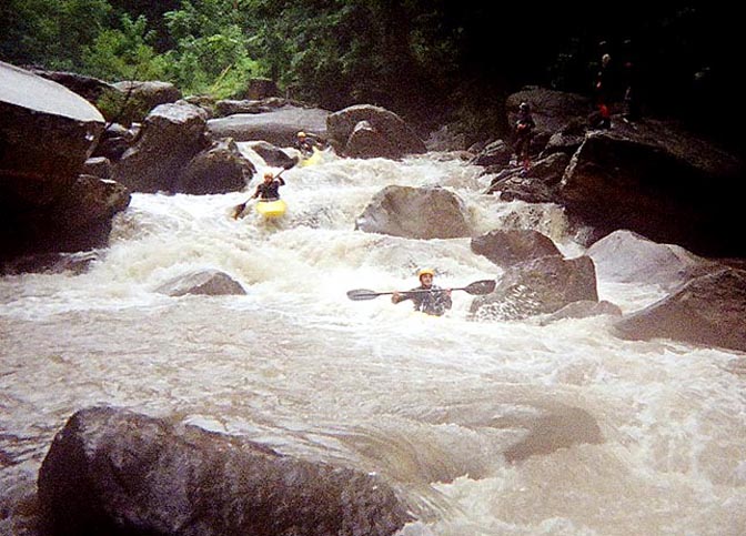
Louie running some technical boogie water on the LRB.