Catawba
Great Falls Short Channel(Great Falls)
Jul 9, 2023
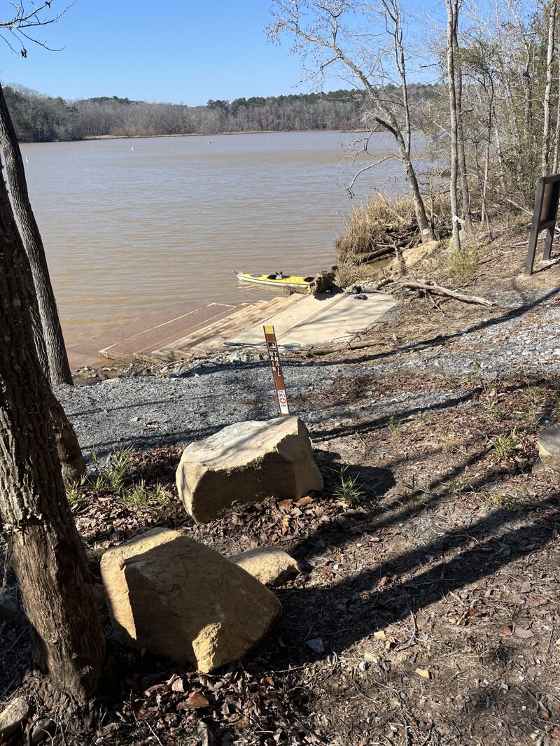
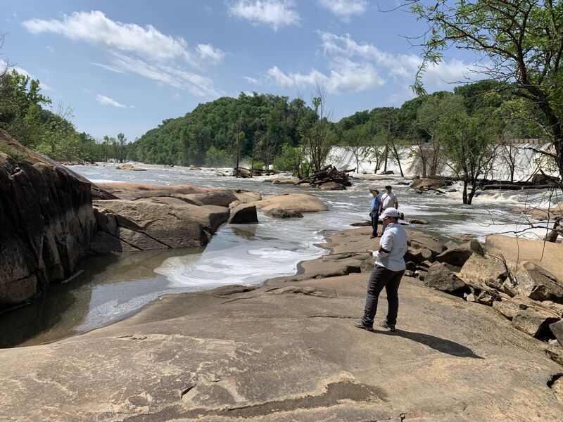
Quick visit to the brand New Canal Street Acces Area.
Feb 1, 2022
Beta on this run is very, very limited, so hopefully this helps to start adding to the public knowledge of this run. Lots of dead wood due to the fact that flow to this area has been restricted for 110 years so be careful.
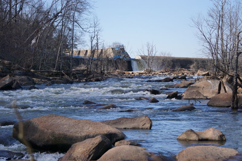
Flow was believed to be around 1800CFS based on the Wylie Hydro Gage data from the day previous (about 20 miles upstream, figured it takes about a day to get here). Myself (Logan Phillips) and Cohen Atkins hiked in from the town of Great Falls. Once at the banks of this channel, we attained up as high as we could on river right, before ferrying across at the base of the upper rapid. Once on river left, its 200 yards of Class IV rock scramble and wading to get to the base of the dam where the water enters the channel. Please do you own research as to how to get to the channel legally, the dam and surrounding land is owned by Duke Power. Currently there is a massive notch cut out of the dam, which is dumping the entire flow of the river into this channel allowing the long channel to stay completely dry during construction. See photos, it's quite an impressive spout of water. No clue how long this will be the setup, but my guess is that until they are done with the work on the long channel (end of 2022), the short channel will be flowing with what I estimate to be about 2000cfs. Any more, and it appears to overflow into the flatwater bypass (channel closest to town). For those of you that aren’t into ridiculous portages and complicated logistics to run a 3 rapids, it might be best to wait until the new put-in is complete and scheduled releases begin.
Without further ado:
'Turtle Back' Rapid (III-?): Starting at the dam, the main flow goes left around a rocky island with a tree. Flow is then split by a logjam. Line is to the right of the logjam. Immediately past the logjam there is Turtleback . There are (at least) 2 options. Go just left of the exposed rock on the right for a straight drop (this might turn into a nasty pour-over at release levels), or head straight down the center, avoiding the Turtle Back shaped rock that is just under the surface about 8' from the river left bank.
'Great Waves' Rapid (III+?): Once through Turtle Back, there is about 50 yards before you enter the meat of the run. You'll see an 8' wide rock that looks like a toilet bowl in the center of the river. This toilet bowl rock marks the start of the rapid. Line is to the right of the toilet bowl. Pick your way down. Lots of surprisingly pushy water, back-to-back small drops and surprise holes. Hug the right bank for the easiest route, or down center-right for a bit more action. Left bank has a submerged tree. Rapid ends in wavetrain that looks like it could liven up at release-level flows. Reminiscent of Radiotower on Lower Noli, just without the getting-stuck-on-every-rock part. Lots of elevation drop over the rapid, but it's a consistnet grade with no major, nameable drops or holes. Looks to be potential for playspots and surfing at release flows.
Next, there is about 150 yards of pool before the second (and final) rapid.
'Barracks Ledge' Rapid (III): The mid-run-pool ends with a small rocky island with a few trees and a river-wide line of boulders. It's a bit of a choose-your-own adventure, but everything to the right of this island is filled with dead wood, so not the adventure I would recommend. We took the left channel, staying 10 yards or so off of the left bank because of the dead wood here also. Around the side of the island, (maybe 75 yards in) you'll see a horizon line. Some lines are cleaner than others, but the best option we saw was to simply run the ledge straight down the middle. It’s about a 3' drop, comparable to a mini version of Murphy's ledge (Noli Gorge). Rest of the way down (200 yards or so) to the lake is just a Class II+ game of dodge-the-barely-submerged rock.
Quick history lesson - around 1800 Washington + Jefferson decided to build an Armory in this area to serve the southern states, at the same time they approved construction of the Harpers Ferry and West Point Armory. Eli Whitney (yep, the Cotton Gin guy) was the one that selected + surveyed the land, and Colonel Senf was the engineer in charge of the construction. Senf died and was buried nearby in an unmarked grave. The armory, barracks, powder magazine, blacksmith shops, and artillery storage sheds were built, and staffed, but nothing was ever produced. The war of 1812 happened and focus/ funding was redirected to Harper’s Ferry + West Point. By 1825 it was abandoned. The 80 acres worth of ruins will be accessible as part of the overall whitewater project and 500+ acre state park, but for now they are on private land.
Nov 30, 2021
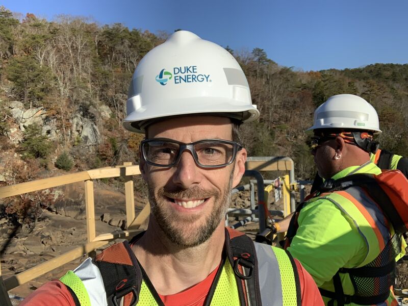
Following several days earlier in the year, this was the day AW pitched our proposed trail layout to the engineers and trailbuilders. This report includes images of the significant modifications underway on the Short Channel Diversion Dam. Workers had shaved off the top several feet of the dam, were tieing the dam into the bedrock with large cables, and were preparing the dam for the instalation of Obermeyer gates that will provide for releases. Because of this work the reservoir was drained, revealing a vast mudflat beneath which are more remnants of the Great Falls.
Jun 24, 2021
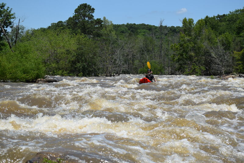
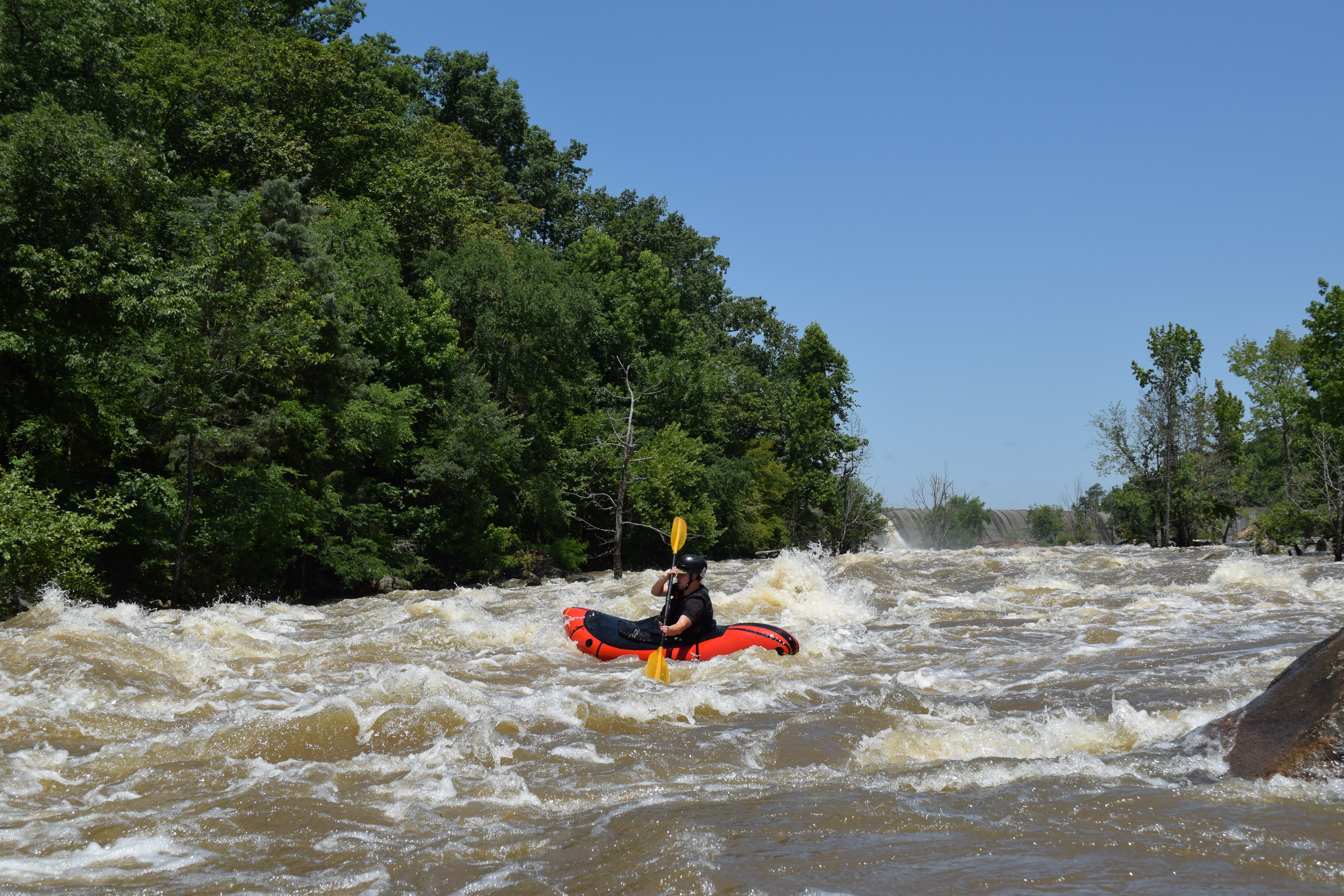
Jack Henderson and I paddled the Short Channel at high flow as part of a trail design day. This was one of a handful of days that I shared with volunteers, Duke staff, and trail engineers exploring the route for a trail along the Short Channel. The packrafts allowed us to paddle the river and run laps on the first big rapid while also hiking back out and recording and flagging potential trail routes.
May 4, 2021
One of 3 or 4 days AW staff spend in the Great Falls establishing a trail route along the Short Channel. On this day we were joined by Duke engineers and recreation staff.
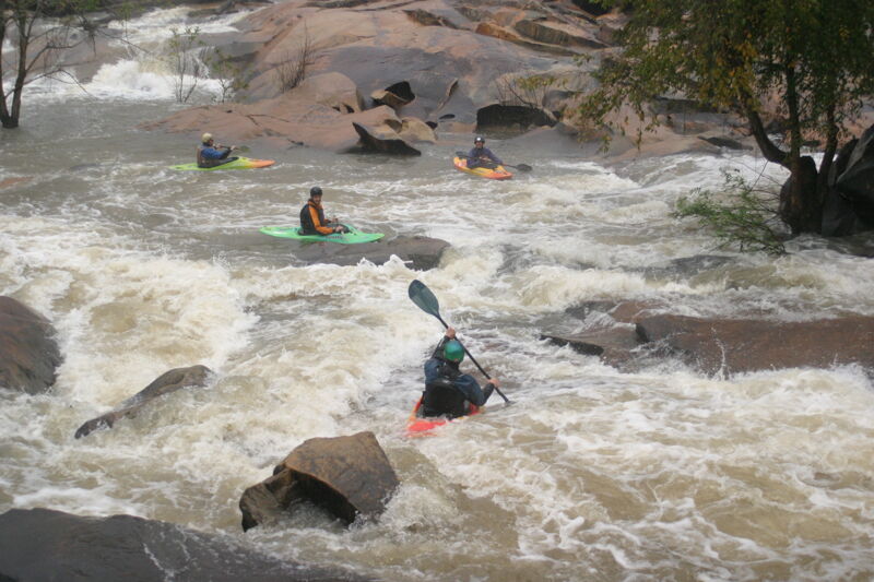
Oct 24, 2004
American Whitewater worked with Duke Energy and many other groups to coordinate a controlled whitewater flow study in October of 2004. This study layed the foundation for flow restoration negotiations. Over one weekend we paddled several different flows on both channels, filling out surveys and having focus group discussions following each run and at the very end. It was a safe, fun, and informative weekend!
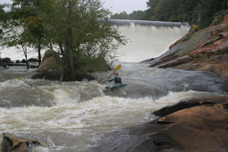
Oct 23, 2004
American Whitewater worked with Duke Energy and many other groups to coordinate a controlled whitewater flow study in October of 2004. This study layed the foundation for flow restoration negotiations. Over one weekend we paddled several different flows on both channels, filling out surveys and having focus group discussions following each run and at the very end. It was a safe, fun, and informative weekend!
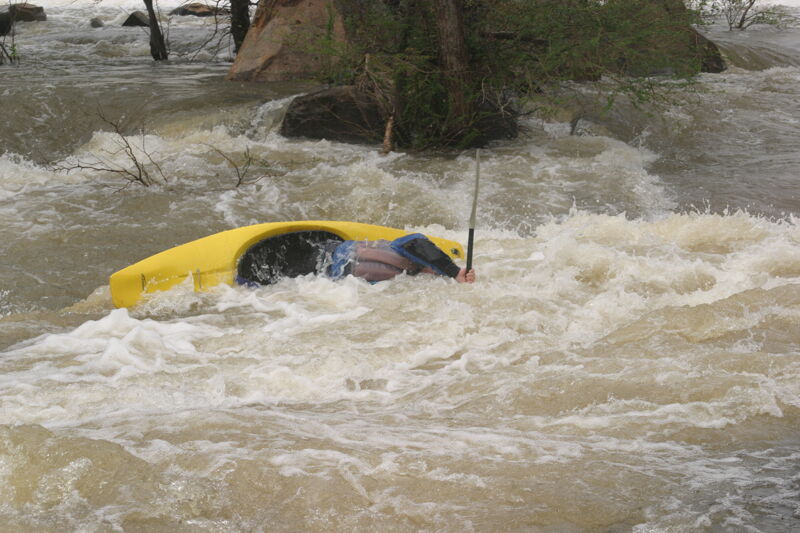
Oct 23, 2004
American Whitewater worked with Duke Energy and many other groups to coordinate a controlled whitewater flow study in October of 2004. This study layed the foundation for flow restoration negotiations. Over one weekend we paddled several different flows on both channels, filling out surveys and having focus group discussions following each run and at the very end. It was a safe, fun, and informative weekend!