Salmon, North Fork
Right Hand Fork to Mule Bridge(Wilderness Run)
May 18, 2024
Date: 5/18/2024
Boats: 2 Alpacka Wolverines, 1 Gnarwhal
Total hike-in miles: 6 (Mule Bridge to put-in at Right Hand Fork, in 3 hours)
Hike-out miles: Diana hiked-out the last 1.5 miles
Total paddled miles: 6 (Right Hand Fork to Mule Bridge, in 3 hours)
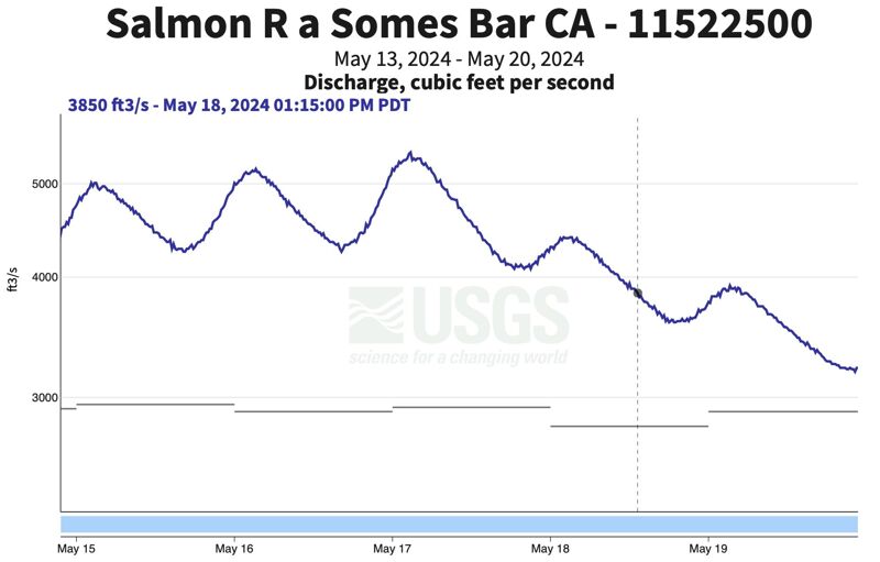
Flow: 3850 on Somes Bar gage
GoPro Video: NF Salmon Wilderness GoPro Video
Last year Lynn and I attempted this hike-in section of the NF Salmon. We did a lot of scouting and portaging, and ended up hiking out after only paddling a couple miles. We learned a lot (see previous trip report), and I really wanted to come back with a bigger crew and a little more water. This year, when flows looked like they were going to be in a good range, Scott and Diana rallied for another attempt. See Scott’s trip report for details about flows and wood conditions. Flows ended up being the same as last year’s trip, but it was just enough! And with all the wood we encountered, I was glad it was on the low side.
We started hiking from Mule Bridge at 9:15 am. The hike was pretty straightforward. Some poison oak dodging, a few downed trees, and a couple creek crossings that were lower than last year. We didn’t spend much time scouting the river besides a couple rapids that are obvious from the trail. We noted when we crossed the upper bridge that there was a log in the micro gorge downstream of the bridge, but it was a different log than last year and it was propped high enough on the right side to sneak under it. We arrived at Right-Hand Fork after hiking for 3 hours. We spent about an hour eating lunch and transitioning to boating.
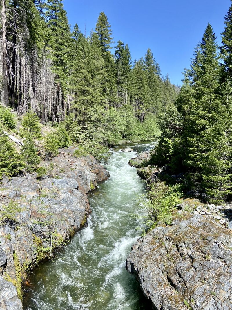
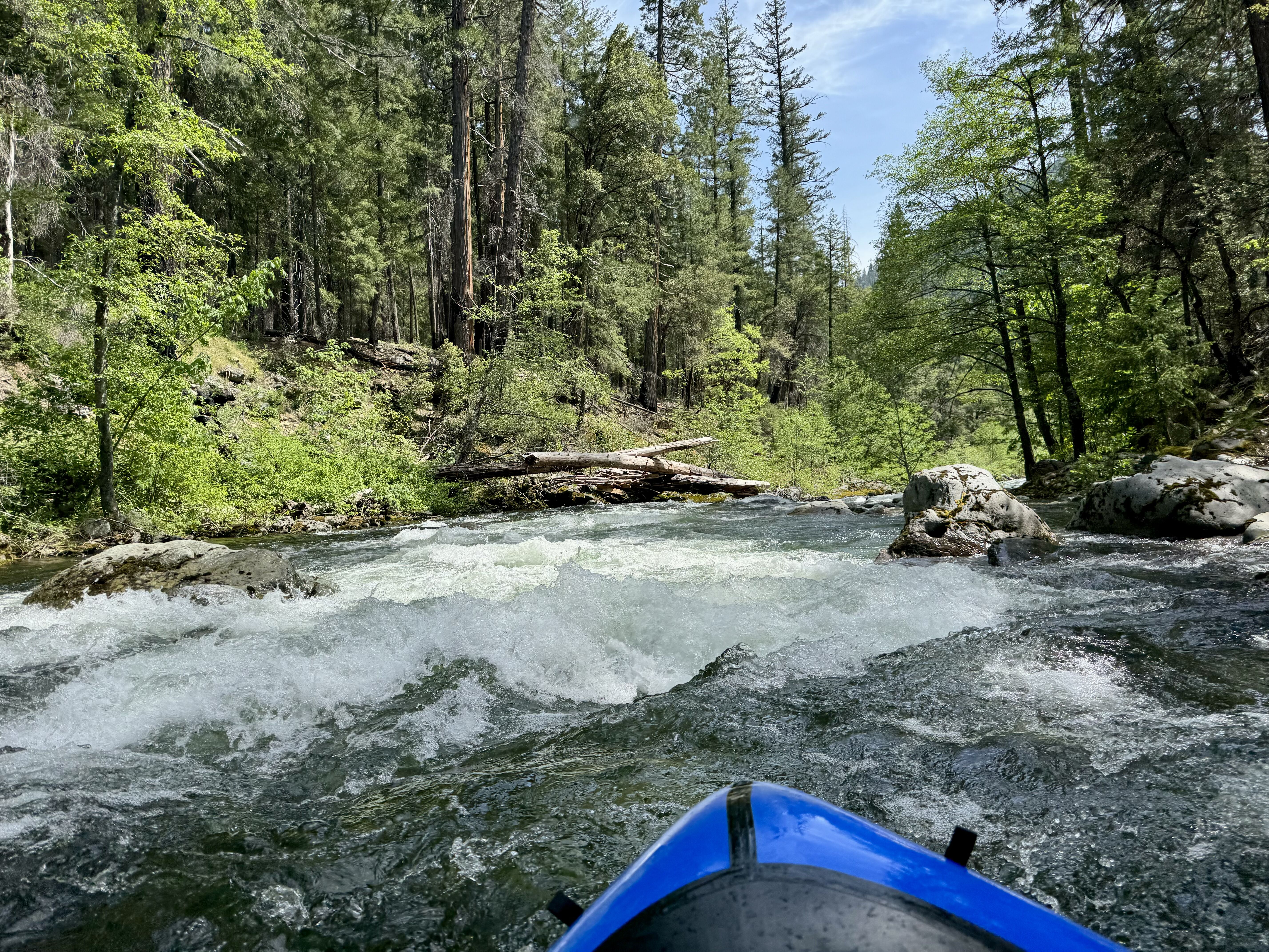
We put on the river at Right-Hand Fork at 1:30 pm. Not long after, we did our first wood portage. There was a lot of wood in play throughout the run that required ducking, dodging, or carefully sneaking around. We had 6 wood portages in total. We didn’t portage any rapids besides one that had an unavoidable wood hazard. The first couple miles had a couple notable rapids. I was excited to finally paddle the rapid just upstream of the bridge that drops into the micro gorge. I’ve had a photo of it on the background of my phone for the last year, but I didn’t get to run it last time. I didn’t get as far left on the entrance as I should have, but all three of us made it through the rapid without incident. About 0.3 miles downstream of the bridge, Diana flipped in the folding seam rapid. It was a short drop and not much of a swim. She flipped again in another chunky rapid downstream, but again not much of a swim.
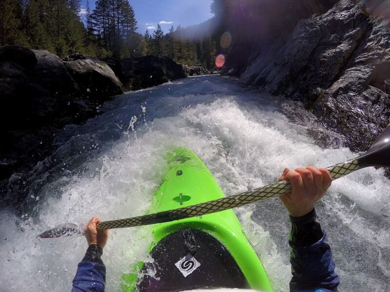
The middle of the run gets pretty continuous. At the flows we did it, there were plenty of eddies and short pools between rapids, but there was enough continuous whitewater to make it a very active paddle. Scott led because he was the strongest paddler, and had done this run a couple times before. As a drop approached, I saw Scott make a quick, hard left. There was a shallow rock in front of me, so I couldn’t immediately make that move, nor did I know yet why he had. Then I saw the pine branches sticking out of the hole in the bottom of the drop, where the flow was taking me. I frantically tried to paddle left, but it was too late. I was sideways at this point and I thought I was going to skewer my boat on wood or flip and get caught in the branches. Fortunately I just gently slid over it, and easily escaped the hole. Definitely not a situation I wanted to be in, but I got lucky this time. I breathed a sigh of relief as I eddied out, but I looked over my shoulder and saw Diana’s boat upside down at the bottom of the drop on the right. She had gone right trying to avoid the wood hazard she saw me approaching, but the right side was a bigger drop and bigger hole. I saw her being swept downstream on river right, and yelled “swimmer!” to Scott, who eddied out behind a rock. Then Diana rolled into a swimming position, ditched her paddle, and swam as hard as she could towards river left. That’s when I realized there was a log spanning 3/4th’s of the river from the right side, lurking below a small drop. Fortunately Diana saw it in time and took action to swim away from it, and was able to get to an eddy on river left. I chased after her paddle a short way, but didn’t want to get too far from the group. Scott was retrieving Diana’s boat. I had packed a spare paddle, so I got that out of my cargo fly. It was an old, janky, not whitewater paddle, but better than nothing (I thought). I gave Diana the spare paddle, and once she was reunited with her boat we continued on.
We eddied out to scout a rapid with wood in it. I checked in with Diana, knowing full well that after several swims, including the last long and scary one, she must be getting tired. She confirmed that she was feeling pretty spent, and said she was considering hiking out. We just so happened to be at the exact spot that I had decided I was “over it” last time, and I had found out the hard way that it was NOT a good spot to hike out. I told her that if we went a little further, the trail would come back down to river terrace level, and be better for hiking out if that’s what she wanted to do. After portaging the rapid with wood, we continued on.
Partway through a riffle I heard Diana shout to me. I looked back and saw that the paddle blade was bent at a 45 degree angle to the shaft, and she was yelling that it was breaking. I tried yelling ahead to Scott, who didn’t hear me. I eddied out and whistled, and just as I got Scott’s attention, Diana’s paddle blade fell off. There was some wood blocking the left half of the river, and in the chaos of losing the paddle and trying to avoid the wood she swam again. Scott was able to assist her, but now she was on the opposite side of the river from the trail, without a paddle. We were still in the riffle, but there was a calm pool downstream. Scott gave her his paddle and volunteered to hand-paddle to the bottom of the riffle. We all eddied out on river left once in calm water. Scott did a quick map check, and confirmed that we were about 1.5 miles from Mule Bridge. Since we were so close to finishing, I asked if they were ok with Diana hiking out and me and Scott continuing to paddle. They both agreed to that plan. Scott and I continued down river, paddling a couple drops that we saw from the hike-in. I took the left sneak line on the wide, chunkiest rapid of the river, and Scott made it down the middle. We had one last wood portage. Then we victoriously paddled final boulder garden before the bridge, which I *almost* flipped in the very last drop but saved it. We were only on the water for about 20 more minutes after parting with Diana, taking out at Mule Bridge around 4:40 pm. Diana hiked over the bridge a little after 5 pm. It felt glorious to get to paddle all 6 miles, and I’m happy the lessons I learned from last time really paid off.
May 18, 2024
After two earlier trips on this run, the first at 7,000 cfs in a kayak and the second at 10,000 cfs in a packraft, I was interested to return at lower flows to try figure out what the lower end range of decent flow is for this run. We found it.
After a week of Salmon River flows swinging on the snowmelt diurnal with peaks of 5,000+ cfs and lows around 4,000 cfs on the USGS Somes Bar gage, one cool night at elevation dropped flows significantly so that when we put on this run around 1 pm the gage was reading 3,850 cfs and dropping 35 cfs/hour. We paddled the run on the declining limb of the diurnal cycle between its high of 4,400 cfs from the previous day's snowmelt and a low of 3,600 cfs from the cool night before our trip. The USGS gage is nearly 50 miles downriver so its correlation is not super tight and there is a significant timing offset, but it's fairly good when the flow dynamics are simple as they were in this case (all snowmelt, no rain, and on a consistent pattern). This same flow at the Somes Bar gage when there is rain or elevated base flows in the mix would not provide enough water for this run...interpreting the gage is an art and science.
Actual flow at the put-in just below the confluence of the Right Hand Fork and North Fork was an estimated 400 cfs. The stage gage on the downstream river right side of the Sawyers Bar Road bridge just below Idlewild Campground was reading 3.0 feet at the end of our trip. This old-school stick gage is the best indicator of flow for this run. A flow of 3,850 cfs is a low flow, but it's certainly adequate and enough to be worth the effort of getting to the put-in. That said, this is near the lowest flow I'd choose for the run--but I tend to favor more water over less.
The hike in was easy with a couple dozen small diameter fallen tress across the trail, all of which were easily traversed. A few larger ones required only minimal effort to get over, under, or around (kayakers would've had to offload boats a time or two). The trail had not yet been maintained for the season. The two stream crossings were straightforward and could be crossed while keeping shoes on and dry: Yellow Dog Creek was low enough to rock hop across and Big Creek had a fallen tree across it that made for a dry crossing. At an easy pace, we reached the put-in at the Right Hand Fork in almost exactly three hours including short stops to look at the river, check out wood hazards, and take photos.
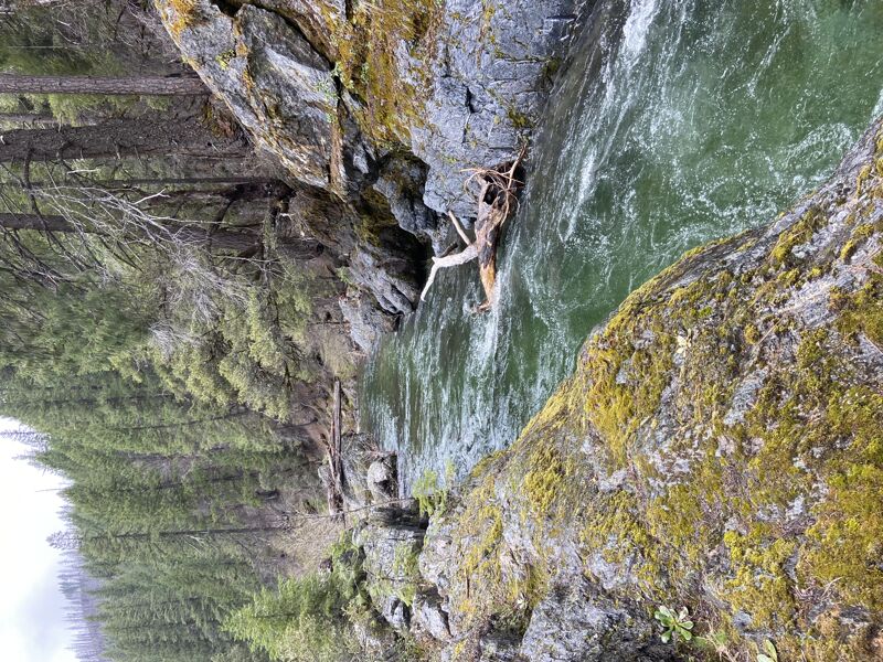
On the river, wood was the theme. Not far below the put-in we encountered our first wood hazard. In all, there were at least 15 wood hazards in play on the run. We were able to duck and dodge many but still ended up portaging about six times. One strainer looked as if it were purpose built for snaring packrafts. Much of the wood consisted of trees that fell directly from the banks into the river but some had also been transported from upstream. Always be alert for wood on this run! This is the most wood I've encountered on my three runs here.
Even with the wood, the run was great. The flow was low but not so much that we hit many rocks or that it detracted from the experience. At two wide spots we grounded out on boulder bars but that was it; even those we didn't have to get out of the boats to bump over. Much of the run is gorged in and there was ample water in these sections. No complaints doing at this flow, and it certainly could be run a bit lower, especially by packrafts. The extremely low flow threshold is likely closer to 3,000 cfs at the gage or 2.8 feet on the bridge stick gage (both guesstimates).
The water quality was spectacular with clear, emerald pools (in contrast, on this day the South Fork Salmon was turbid and brown). We saw a number of merganser pairs, some kingfishers, and wayward cow that obviously overwintered in the wilderness on the opposite side of the river from the trail. Skies were blue and we had full sun on the water most of the day, punctuated by slight overcast in the mid afternoon and encroaching shadows on the lower part of the run as the afternoon wore on.
As always, the hike and the river run were gorgeous and the epitome of a great day in the wilderness. Count on the hike taking about 3 hours and the run taking about 2-3 hours at this flow (quicker if there's less wood). We started hiking at 9 am, got to the put-in at noon, on the water at 1:30 pm after lunch and a leisurely transition, and to the take-out at 4:45 pm, all at a leisurely pace and with added time to deal with the wood and typical packraft routines on the water.
May 5, 2023
Date: 5/5/2023
Boats: Packrafts (Alpacka Wolverine and Expedition)
Total hike-in miles: 5.2 (Hiked 0.5 mile past the bridge, then back tracked 0.5 miles to put-in below the bridge)
Hike-out miles: 2.25
Total hiked miles: 7.45
Total paddled miles: 2
Flow: 3850 on Somes Bar gage that morning
GoPro Video: NF Salmon Wilderness Run
This trip ended up being more of a recon mission, but we had a great time and learned a lot for next time. One of the big questions we had was: How low is too low for this run? At the time of our trip, it had only been run twice. The second known descent was only a week prior, when flows were 10,000 cfs at Somes Bar, and it was continuous Class IV. Not what we wanted! But just a week later, flows had dropped slightly below the estimated minimum flow, which was 4,000 cfs. A short jaunt across the Mule Bridge and up the trail a half mile the night before our attempt looked promising, so we decided to give it a shot.
Before starting our hike, we decided to set a shuttle car at the Idlewild campground, in case we paddled the wilderness section in good time and decided to run the Mule Bridge to Idlewild section after. On our drive from the Idlewild campground to Mule Bridge, we stopped a few times to scout some of the sections of river.
1. Hindsight Lesson: We were dreaming when we thought we’d have enough time left over. I wish we would have driven straight to Mule Bridge and not bothered with setting a shuttle or scouting the upper Idlewild run. It would have given us more precious time for the wilderness run.
2. Hindsight Lesson: As far as I can tell, the rapids in the Mule Bridge to Idlewild stretch are a step up from what you encounter on the wilderness hike-in section.
We started hiking from Mule Bridge at 10:45 am. There appeared to be plenty of water flowing under the bridge! We soon saw a short drop that looked a little boney, but doable. We spent a few minutes scouting and continued on. The trail departed upslope from the river slightly, giving us a good view of a longer rapid. It looked really boney, and it was hard to see a clear line from where you could enter the rapid to where there was enough water at the end. I also saw some branches sticking out of a hole, indicating wood was lurking below. After some consideration, we decided we’d want to portage this one. We took some time trying to figure out how we’d recognize it from upstream, and where we could get out to portage. We came across a couple stream crossings that had a surprising amount of water flowing, one was calf deep and one was knee deep. I wondered what it was like the week before at high flows (I found out later my friend “swam” on the hike in when she got swept off the trail at the crossing). The trail went inland from the river, and we didn’t see it for a while. The trail continued to climb in elevation, until we were much higher than the river channel.
3. Hindsight Lesson: I had naively assumed we’d be able to keep an eye on the river on the hike in and scout for wood, and that if we ran into trouble on the river, the trail wouldn’t be far. This is NOT THE CASE for a lot of the trail. I wish I had marked more points along the way so I knew where river access points were. This becomes a hard earned lesson later in my story…
At some point, we caught a glimpse of the river waaaaaay down below us. We didn’t have much of a view, but 1. I realized just how far the trail was from the river at this point, and 2. We could see a sizeable log in the river. It also looked like there was some whitewater downstream, but we couldn’t see it well through the trees. We took a mental note of this, but figured it would be hard to know when we got to that spot once we were on the river. We continued on, and eventually the trail dropped back down to river terrace level. We stopped to eat lunch at 12:45 pm, about a half mile before the middle bridge, on the edge of a microgorge. We could see there was a nice little drop into the gorge, and some wood partially in the river channel downstream, but at these flows the water looked pretty calm around the wood, so it didn’t look hard to avoid. As we crossed the bridge we could see a river-wide log about a foot off the water in the microgorge downstream of the bridge. Which meant we would have to portage the entire micro gorge, upstream of the bridge. We continued hiking, at this point thinking we’d put in at Abbott Ranch, a half mile upstream from the bridge. We saw a couple small rapids that looked pretty boney, and knowing that we’d have to portage the log in the micro gorge, we decided it wasn’t worth it to put in above the bridge this time. We backtracked to put in downstream of the log blocking the microgorge. We finally got on the water around 2 pm.
Then the fun started! The river had a quick pace, and although it felt boney at times, some places the river constricts and it felt plenty fluffy! Since it was just the two of us, and we were in a wilderness setting, we didn’t want to take any chances so we ended up getting out of our boats a lot to scout. Most of the rapids and drops were short and sweet, so we didn’t need to see much to know it was good to go, but it did slow us down. Lots of sections were fun, continuous Class II. On one of the bonier drops, I flipped on a shallow rock that I couldn’t see, and went for a swim. I held onto my boat briefly, but after getting washed through a little hole I got separated and swam to an eddy. My boat continued on and Lynn chased after it. Luckily this section was mellow and Lynn felt comfortable continuing without needing to scout, but it really hit home that this river can be continuous, and I definitely didn’t want to lose my boat! I was able to easily run along a river terrace and reunite with Lynn and my boat. We continued on, leap frogging leading and eddying out. We came upon a left bend in the river with two channels. The larger, inner left channel had a massive log jam. We eddied out on river left and saw that the smaller, outer channel went around a bend that we couldn’t see, and the outer bank was cliffed out. Given how much wood was in the left channel, and not being able to see or portage on the right, we decided not to take our chances and portaged on the left. The willows were annoying to get through, but we got back in our boats and continued on. We came up to a drop that we couldn’t see well, so we got out to scout. I saw a big log in the river and realized this was the spot we had seen on the trail far above. The drop was a steep and boney chute, and it didn’t look good at these flows. Lynn could see the river looked good immediately downstream, but it disappeared around a bend again. We decided to portage, which ended up being tricky to find a way downstream through the willows. At this point I was feeling pretty tired from my swim and the previous portage, and I was generally feeling like it was getting kind of late. It was already 6 pm by this point, and it had been raining for a while. I knew we had a couple hours of daylight left, but I was feeling nervous about our progress. In our attempt to portage I saw we were at an old mining camp, so logic dictated that there must be a spur trail back to the main trail. I made the call that I wanted to hike out. Looking at the forest service map later, I saw that we took out at a place called “The Cedars.” Walking uphill, we quickly found an obvious trail. We figured it would eventually connect with the main trail.
4. Hindsight Lesson: I recognized this spot from when the trail was waaaaay uphill from the river. I should have considered that it could pose a problem. Later, looking at aerial imagery I discovered it was a burned area, and the old trail had slid out. The new trail was rerouted much higher up.
Pretty soon, the obvious trail became less obvious as it crossed a scree slope, and became more of a game trail. The events that happened next still rattle me, because I definitely thought that I’d be smart enough not to get stranded on a steep scree slope clinging for my life, but that’s pretty much what happened. I’ll won’t go into too much detail on this trip report since it isn’t related to the paddling, but I will say that we (and more so I) ended up in a very precarious position trying to cross a washed-out trail. It could have ended badly, but luckily it didn’t. After some close calls, use of throw ropes to haul my pack and then me up a way-too-steep slope, we reached the main trail around 7:45 pm. Only to find that the trail dropped back down to river terrace level shortly after, and the section past the portage looked fine.
5. Hindsight Lesson: If we had portaged then stayed on the river, we would have avoided that whole debacle. And we still could have gotten off the river soon, at a better spot. Had we marked some egress points, and a “do not exit” point on our hike in, we could have made some better decisions.
It was almost dark by the time we got to the car, and still raining. We went and retrieved her car from Idlewild, and got back to our camp around 9 pm, utterly exhausted.
In the end, it was more of a lack of time, not a lack of water, that prevented us from paddling more of the river. Is 3850 cfs too low? I’d say it's still worth doing at those flows, just don’t expect to run every rapid or put in as high.
Mar 28, 2017
In 2017, I dreamed up the idea of a one-day kayak trip from the headwaters of the North Fork Salmon River to its confluence with the South Fork Salmon over 30 miles downstream in Forks of Salmon.
This starts with a seven mile wilderness hike to the put-in where the North Fork and its major fork, the Right Hand Fork, come together in the Marble Mountain Wilderness Area and provide enough water to float a kayak when the snow is melting. It ends in Forks of Salmon where the South Fork and North Fork join. That happens to be very convenient as the journey ends at home for me. In between is a whole lot of world class whitewater kayaking and stunning scenery in an amazing West Coast watershed.
In late March 2017, three of us gave this an unrehearsed attempt with a late morning start to the adventure. We didn't take a map or a water bottles; that wasn't a mistake: you need neither here. Just a boat. We almost made it. Flows were dropping slowly and when we put on the gage at Somes Bar read 7,000 cfs. This was a healthy medium flow for this run: plenty of water but not too high and a few of the bouldery rapids in the second half were still a bit chunky.
We cut short on the upriver end due to unexpected snow on the trail that slowed us down and pointed us into the water still later than was perhaps ideal given that we had 30+ miles to go, some of it easy and unknown, some of it more familiar and up to class V. Having enough water in the headwaters means having quite a bit of water downstream in the granite canyon.
The journey was spectacular, the upper river unknown to all of us as it is to anyone else but somehow, no more difficult than class III+. We literally drank the waters and used that sustenance to keep going. Two of us continued past the halfway mark near Sawyers Bar, paddling in the slanted light of evening as the gorge tightened and water poured in from all sides, making the river bigger every mile as the gradient and difficulty increased.
But daylight and prudence cut us off just before dark and about two miles short of our goal in Forks of Salmon. We pulled out at the swinging bridge, just before entering Indian Point Gorge and its thundering class IV and V rapids. We left just enough on the table to make going back soon a worthy cause and a new adventure. I'll be looking for a couple paddling partners for that too. This is the season.
This adventure included the following runs: