Salmon, North Fork
Right Hand Fork to Mule Bridge(Wilderness Run)
May 5, 2023
| Reporter | Sara Gallagher |
| Gauge Reading | 3850 cfs at SALMON R A SOMES BAR CA |
| Flow | Low Runnable |
Date: 5/5/2023
Boats: Packrafts (Alpacka Wolverine and Expedition)
Total hike-in miles: 5.2 (Hiked 0.5 mile past the bridge, then back tracked 0.5 miles to put-in below the bridge)
Hike-out miles: 2.25
Total hiked miles: 7.45
Total paddled miles: 2
Flow: 3850 on Somes Bar gage that morning
GoPro Video: NF Salmon Wilderness Run
This trip ended up being more of a recon mission, but we had a great time and learned a lot for next time. One of the big questions we had was: How low is too low for this run? At the time of our trip, it had only been run twice. The second known descent was only a week prior, when flows were 10,000 cfs at Somes Bar, and it was continuous Class IV. Not what we wanted! But just a week later, flows had dropped slightly below the estimated minimum flow, which was 4,000 cfs. A short jaunt across the Mule Bridge and up the trail a half mile the night before our attempt looked promising, so we decided to give it a shot.
Before starting our hike, we decided to set a shuttle car at the Idlewild campground, in case we paddled the wilderness section in good time and decided to run the Mule Bridge to Idlewild section after. On our drive from the Idlewild campground to Mule Bridge, we stopped a few times to scout some of the sections of river.
1. Hindsight Lesson: We were dreaming when we thought we’d have enough time left over. I wish we would have driven straight to Mule Bridge and not bothered with setting a shuttle or scouting the upper Idlewild run. It would have given us more precious time for the wilderness run.
2. Hindsight Lesson: As far as I can tell, the rapids in the Mule Bridge to Idlewild stretch are a step up from what you encounter on the wilderness hike-in section.
We started hiking from Mule Bridge at 10:45 am. There appeared to be plenty of water flowing under the bridge! We soon saw a short drop that looked a little boney, but doable. We spent a few minutes scouting and continued on. The trail departed upslope from the river slightly, giving us a good view of a longer rapid. It looked really boney, and it was hard to see a clear line from where you could enter the rapid to where there was enough water at the end. I also saw some branches sticking out of a hole, indicating wood was lurking below. After some consideration, we decided we’d want to portage this one. We took some time trying to figure out how we’d recognize it from upstream, and where we could get out to portage. We came across a couple stream crossings that had a surprising amount of water flowing, one was calf deep and one was knee deep. I wondered what it was like the week before at high flows (I found out later my friend “swam” on the hike in when she got swept off the trail at the crossing). The trail went inland from the river, and we didn’t see it for a while. The trail continued to climb in elevation, until we were much higher than the river channel.
3. Hindsight Lesson: I had naively assumed we’d be able to keep an eye on the river on the hike in and scout for wood, and that if we ran into trouble on the river, the trail wouldn’t be far. This is NOT THE CASE for a lot of the trail. I wish I had marked more points along the way so I knew where river access points were. This becomes a hard earned lesson later in my story…
At some point, we caught a glimpse of the river waaaaaay down below us. We didn’t have much of a view, but 1. I realized just how far the trail was from the river at this point, and 2. We could see a sizeable log in the river. It also looked like there was some whitewater downstream, but we couldn’t see it well through the trees. We took a mental note of this, but figured it would be hard to know when we got to that spot once we were on the river. We continued on, and eventually the trail dropped back down to river terrace level. We stopped to eat lunch at 12:45 pm, about a half mile before the middle bridge, on the edge of a microgorge. We could see there was a nice little drop into the gorge, and some wood partially in the river channel downstream, but at these flows the water looked pretty calm around the wood, so it didn’t look hard to avoid. As we crossed the bridge we could see a river-wide log about a foot off the water in the microgorge downstream of the bridge. Which meant we would have to portage the entire micro gorge, upstream of the bridge. We continued hiking, at this point thinking we’d put in at Abbott Ranch, a half mile upstream from the bridge. We saw a couple small rapids that looked pretty boney, and knowing that we’d have to portage the log in the micro gorge, we decided it wasn’t worth it to put in above the bridge this time. We backtracked to put in downstream of the log blocking the microgorge. We finally got on the water around 2 pm.
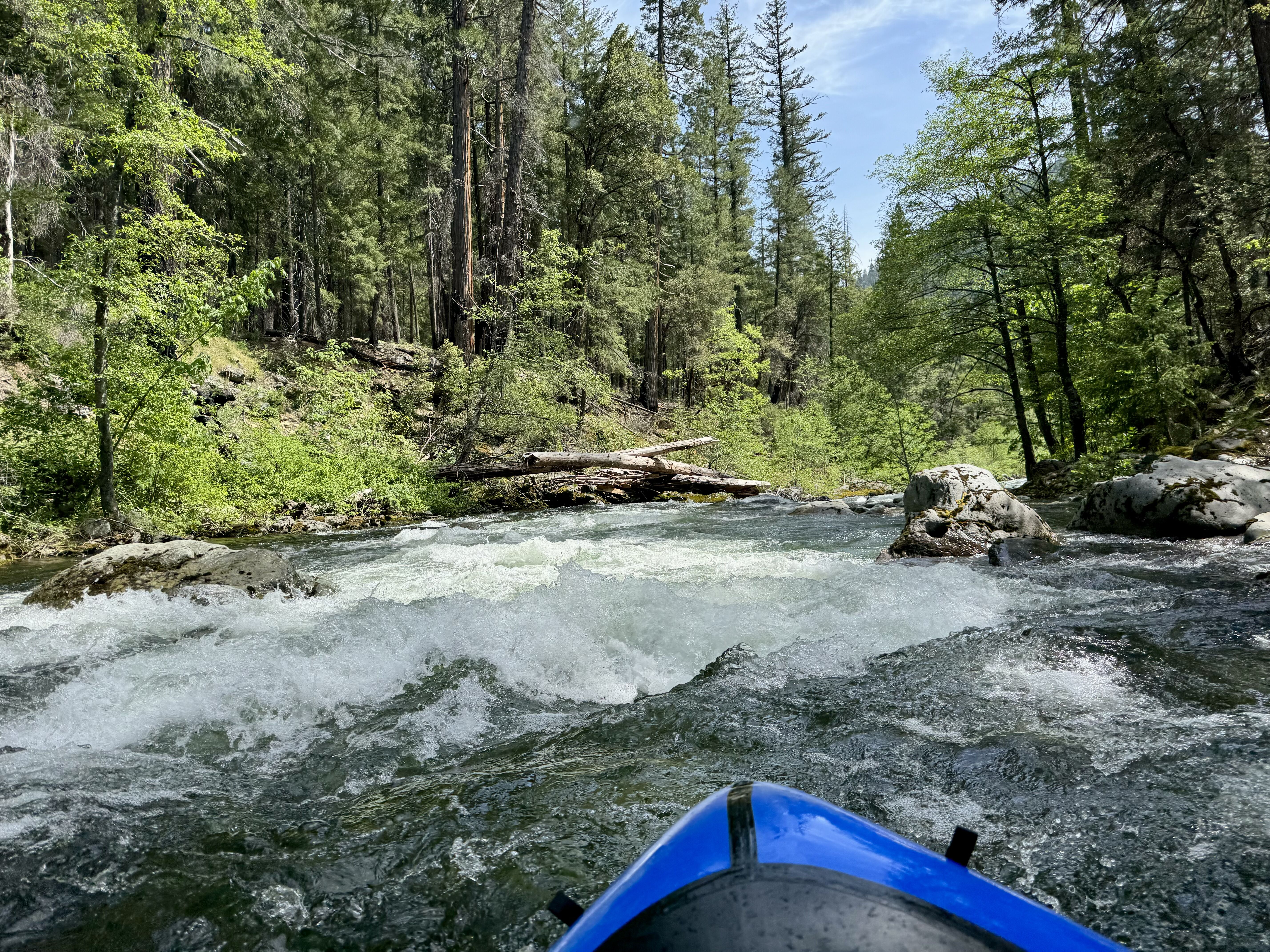
Then the fun started! The river had a quick pace, and although it felt boney at times, some places the river constricts and it felt plenty fluffy! Since it was just the two of us, and we were in a wilderness setting, we didn’t want to take any chances so we ended up getting out of our boats a lot to scout. Most of the rapids and drops were short and sweet, so we didn’t need to see much to know it was good to go, but it did slow us down. Lots of sections were fun, continuous Class II. On one of the bonier drops, I flipped on a shallow rock that I couldn’t see, and went for a swim. I held onto my boat briefly, but after getting washed through a little hole I got separated and swam to an eddy. My boat continued on and Lynn chased after it. Luckily this section was mellow and Lynn felt comfortable continuing without needing to scout, but it really hit home that this river can be continuous, and I definitely didn’t want to lose my boat! I was able to easily run along a river terrace and reunite with Lynn and my boat. We continued on, leap frogging leading and eddying out. We came upon a left bend in the river with two channels. The larger, inner left channel had a massive log jam. We eddied out on river left and saw that the smaller, outer channel went around a bend that we couldn’t see, and the outer bank was cliffed out. Given how much wood was in the left channel, and not being able to see or portage on the right, we decided not to take our chances and portaged on the left. The willows were annoying to get through, but we got back in our boats and continued on. We came up to a drop that we couldn’t see well, so we got out to scout. I saw a big log in the river and realized this was the spot we had seen on the trail far above. The drop was a steep and boney chute, and it didn’t look good at these flows. Lynn could see the river looked good immediately downstream, but it disappeared around a bend again. We decided to portage, which ended up being tricky to find a way downstream through the willows. At this point I was feeling pretty tired from my swim and the previous portage, and I was generally feeling like it was getting kind of late. It was already 6 pm by this point, and it had been raining for a while. I knew we had a couple hours of daylight left, but I was feeling nervous about our progress. In our attempt to portage I saw we were at an old mining camp, so logic dictated that there must be a spur trail back to the main trail. I made the call that I wanted to hike out. Looking at the forest service map later, I saw that we took out at a place called “The Cedars.” Walking uphill, we quickly found an obvious trail. We figured it would eventually connect with the main trail.
4. Hindsight Lesson: I recognized this spot from when the trail was waaaaay uphill from the river. I should have considered that it could pose a problem. Later, looking at aerial imagery I discovered it was a burned area, and the old trail had slid out. The new trail was rerouted much higher up.
Pretty soon, the obvious trail became less obvious as it crossed a scree slope, and became more of a game trail. The events that happened next still rattle me, because I definitely thought that I’d be smart enough not to get stranded on a steep scree slope clinging for my life, but that’s pretty much what happened. I’ll won’t go into too much detail on this trip report since it isn’t related to the paddling, but I will say that we (and more so I) ended up in a very precarious position trying to cross a washed-out trail. It could have ended badly, but luckily it didn’t. After some close calls, use of throw ropes to haul my pack and then me up a way-too-steep slope, we reached the main trail around 7:45 pm. Only to find that the trail dropped back down to river terrace level shortly after, and the section past the portage looked fine.
5. Hindsight Lesson: If we had portaged then stayed on the river, we would have avoided that whole debacle. And we still could have gotten off the river soon, at a better spot. Had we marked some egress points, and a “do not exit” point on our hike in, we could have made some better decisions.
It was almost dark by the time we got to the car, and still raining. We went and retrieved her car from Idlewild, and got back to our camp around 9 pm, utterly exhausted.
In the end, it was more of a lack of time, not a lack of water, that prevented us from paddling more of the river. Is 3850 cfs too low? I’d say it's still worth doing at those flows, just don’t expect to run every rapid or put in as high.