Otter Brook
East Sullivan to Otterbrook Park
| Difficulty | III-IV |
| Length | 3.3 mi |
| Avg Gradient | 82 fpm |
| Gauge | Ashuelot River Above the Branch, at Keene, Nh |
| Reach Info Last Updated | December 20, 2023 |
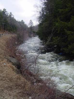
Otter Brook is a small creek located in southwestern NH. NH route 9 parrallels the run for most of the way but is only occasionally visible from the river. It has a continuous gradient over its three mile course. The first half of the river is steeper with a few rock strewn ledge drops one of which is approximately 3Â. This one is located behind a home where the river swings left away from the road. Most paddlers boat scout the river as they run. Be aware that strainers are common; often trees will completely cross over and block the river. In medium to high water be especially cautious of strainers since the velocity of the water will shorten maneuvering time. At the two mile mark you will come across the new Granite Gorge Ski area which was recovered and rebuilt from the old abandoned Pinnacle ski area. From here down the gradient slackens off and becomes more class II-III in nature. This is an alternate put in / take out. Early in the season the take out road at Otter Brook Park may be gated and closed due to snow. It will be necessary to carry up the hill approximately .2 miles. When open the take out is at a picnic area with picnic tables and bathroom facilities. The river from this point on is usually ponded by a flood control dam down to Lower Otter Brook about three miles.
Put in elevation........997'Take out elevation......735'Total drop..............262'Average drop/mile.......82'Distance................3.2 miles1st mile drop...........95'2nd mile drop...........92'3rd mile drop...........65'4th mile drop...........10' (average 50')River width average.....25'River geology...........small to medium granite boulders, some ledge.River water quality.....Good, clear except for quick runoff periods.Scenery.................Good to excellent forest scenery. Route 9 occasionally visible along the river. About three or four homMay 13, 2025
Ran this section yesterday at 330 cfs. The upper section above the ski area was running great but got a little bony below. A little wood on the sides but nothing blocking the full river. Would take out at the ski area next time. Great intro creek with a couple drops and tricky turns!
Jun 30, 2023
Note that there are many strainers fallen fully or partially across the Upper Otter from storms in winter 2022/23.
Jun 8, 2012
The gauge on here is the same as the one for the lower stretch, I'm pretty sure its just the outflow from the dam, so it doesn't seem particularly reliable for the upper stretch. A better measure is the guage painted on the route 9 bridge at the put in. I ran it yesterday at one or a hair over on that guage and its was runnable but bumpy. I wouldn't run it lower than that.