Pemigewasset, East Branch
Franconia Falls to Woodstock.
Apr 16, 2026
This was a fun level, requiring some scouting in places where the drops are steep enough to prevent a good boat scout. The culvert has washed up into the right bank below the island just above Upper Loon Rapids. Upper Loon had the most technical and sustained rapid finishing with several drops, some into stout holes, just upstream of the bridge. Took a barely-in sneak line past the old dams at 'Old Hole' behind Gordi's steakhouse and didn't have to carry. Very fun run to teach and practice good scouting!
Apr 28, 2024
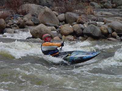
Great run today with 6 paddlers new to the EBP, 6 miles from Lincoln Woods trailhead to the Fire Station in Woodstock. Total run with a few stops took 5 hours. Perfect intro level to learn the demands of this river character as it is not too pushy. The flip side is that there are half a dozen locations where the river widens and water gets thin requiring a few shoves over rocky shoals. 600 cfs would likely be more fluid over the entire range and still a good intro for new paddlers to Class 3/4 rivers. 800 cfs definitely ramps up to more forceful conditions that require faster reaction times. At 400 cfs, LOON RAPID was easy to scout and discuss on river right. We set safety and all who chose to paddle through had no trouble on the typical route of bobbling into the upper pool on river left, then darting across the current diagonally toward river right, aiming for the largest boulder, which creates a smooth line just past the hole on river left-center in the last drop. This river never lets up! The rapids are consistent with steep gradients and many holes and boulders to navigate, with many rapids ending in an unavoidable flushing hole. Only one significant STRAINER at this location tag, a half-mile before Mill Rapid. 44.050704, -71.651645 It is easily seen and does not cover the whole river with a 10-ft bypass on far river right.
Aug 12, 2023
There is a river wide strainer just as the I93 bridge comes into view. It's right below a rapid and around a curve so you can't really see it until you are in the rapid. My best guess of coordinates based on looking on Google maps after the fact: 44.034664,-71.674087
Apr 21, 2006
From longtime AW member Jim Sindelar:
I ran this yesterday (4/20/06).
The level during my run was just under 1 foot on the Kank. Bridge boaters gage. The rapids were definitely 'white,' not green flowing water. I would call it a delightful and exciting level on the low side of 'medium,' definitely not a scratchy low water run. Thus the meaning of the gage has continued to evolve and now seems to be back to the early days of the first gage when 1 foot meant a good medium level.
The strainer identified in the river left drop by the island requiring a portage in 2004 is no longer a problem. The trunk of the tree is still there, but has settled into the river deeply enough that with good control, a clear run is available.
Oct 7, 2005
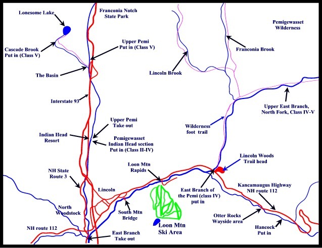
The upper put-in is reached after a two-and-a-half hour (three mile) trek up a trail or road along the river.
Sep 30, 2005
The Upper East Branch begins at the confluence of Franconia Brook and the North Fork of the Pemigewasset. There are old trails/roads along both sides of the river.
The eighth major drop on the Upper East Branch is currently blocked by a strainer requiring a portage or drag around.
Sep 30, 2005
This section of the river, located approximately 3/4 of a mile from the put-in, shows the typical character of the upper East Branch.
Jan 1, 1900
Map of the Upper Pemigewasset River area.