Saco River
1.) Crawford Notch to Bartlett (along Hwy 302)
| Difficulty | III-IV |
| Length | 6.3 mi |
| Avg Gradient | 49 fpm |
| Gauge | Saco River at River Street, at Bartlett, Nh |
| Flow Rate as of 53 minutes | 75 cfsbelow recommended |
| Reach Info Last Updated | May 3, 2018 |
The Saco runs through the highest mountains in the northeastern US. It cuts through a steep valley called Crawford Notch (a NH state park). Outside of the sustain spring melt off the Saco rises and falls rapidly due to steep terrain in its headwaters. If snow is not present it will be necessary to catch the river during or shortly after a heavy rainfall.
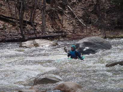
This section starts out at the base of an impressive gorge. This gorge is runable at certain levels but should be scouted. Below the river is consistant class III at low levels. At higher levels this section should be considered class IV due to its consistant gradient. Further down river the consistant gradient turns to more of a pool drop nature with the pools getting larger as one heads down. There is a couple of portions in this lower section where the difficulty increases namely Sawyers rock and Tweedledum Tweedledee rapid. Both these rapids are visible from route 302 when there is no foliage on the trees (mid Oct. thru mid May).
Put in elevation........958'Take out elevation......657'Total drop..............301'Average drop/mile.......49'1st mile................78'2nd mile................43'3rd mile................47'4th mile................40'5th mile................35'6th mile................50'6.2 mile................8' (40' average)Distance................6.2 milesRiver width average.....35'River geology...........Granite ledge, small to medium bouldersRiver water quality.....Excellent, clarity: excellent.Scenery.................Good to excellent mountain scenery, a few homes and camps on the lower reaches, route 302 occasionally visible on river right.Wildlife................occasional deer, moose, perrigrine falcons, hawks.Interstate 95 to Spaulding turnpike (NH rt 16).
North through Conway up to the intersection 302/16 in Glenn (approximately 75 miles).
...
Shortly below the gorge is a series of short but intense drops one after another. Most are short less than 50 yards long but blend together in a long complicated rapid in high water. The rapids become a little easier after the first railroad bridge crossing.
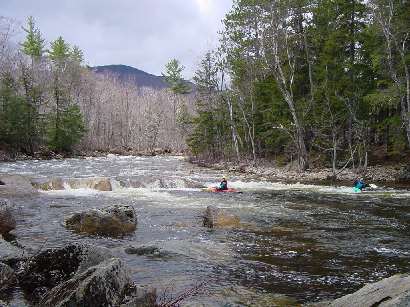
Fairly straighforward but look out for ledge hole at the bottom that can have a rather strong backwash. The rapid can be identified by a smooth ledge rock (Sawyer's) on river right as the river turns to the left. The boulder strewn drop above Sawyer's rock requires a little skill to navigate. This is a popular swimming hole in the summer.
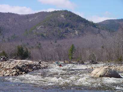
Shortly after Sawyer's Rock rapid comes the biggest drop on this portion of the Saco. The river splits around a mid stream island the right channel is usually not passible except under high water conditions. The left channel drops steeply and contains much turbulance amoung the waves and holes. The best route is just right of center skirting the largest holes on river left formed by the Tweedledum and Tweedledee boulders.
Scouting Group__Photo of Vicky, Buffer, Steve, and Terry at Tweedledum Tweedledee by Kate Hartland taken 5/12/07 @ 1.1'
Apr 3, 2025
At 750cfs the put-in gorge was a very scenic runnable Class IV. It starts with a tight, pinchy move followed by a large eddy. The river then drops through an easier Class III series of punchable wave/holes before leaving the gorge. The best scouting/portaging is on river right along a well-worn social trail. Go across the train tracks and then descend a steep embankment or follow the side stream to put in at the eddy between the two gorge drops. Alternately, stay high on the embankment and continue downstream to bypass the gorge entirely. This is a popular swimming hole in the summer with beautifully clear water.
The rest of the run was low but fluid. We ran all the way to the bridge on River St but wished we'd left the car a bit further upriver on Cobb Rd or Main St since it got wide and scrapy with lots of cobble bars for the last mile or so. Not sure if there is public river access upstream however, so if you're going to do that scout with care.
Oct 4, 2011
Great post Mike.
Carl F and I ran it from just below where you put in and found the run in great shape.
We ran the river on Saturday Oct 1 at 1.0 on the bridge gage.
T-dee / Tdum seemed a little wider on river right. This made the move down the right side a bit more forgiving than before.
Steve Jacques, Bartlett, NH