| Difficulty | III+(IV) |
| Length | 11.1 mi |
| Avg Gradient | 55 fpm |
| Gauge | West Branch St. Regis River Near Parishville Ny |
| Flow Rate as of 1 hour | 1.39 ftbelow recommended |
| Reach Info Last Updated | April 5, 2016 |
River Description
Guidebook : Adirondack Canoe Waters, North Flow
by Paul Jamieson and Don Morris
The hi-light of this river section is the continuousness of the rapids. In the 7.1 miles from St. Regis Falls to Nicholville, there is literally only 100 yards of flatwater paddling. I cannot speak to the section from Nicholville to Fort Jackson, as I have never run this lower part.
Put in is at the base of the falls in St. Regis Falls at the campground. This campground is right on the river and has some nice cabins, if you want to make a weekend of it.
Start with 0.3 miles of class II water. At that point, you will see a horizon line. Here the river splits around a rock outcrop and drops about 8 feet. To the right of the rock, the drop is rated class III/IV and to the left, the drop is rated class IV. The line to the right has some rocks in the hydraulic at the base, so hitting the correct line is critical. The line to the left drops into a deceptively sticky hydraulic. Get out to scout on the side of the river you want to run. If you are going to carry, the right side is preferred.
Immediately below the drop, you encounter class III rapids. Then the river alternates between class II and III for 0.7 miles to a short flatwater section. This is the backwater from an old, broken dam. This is the only flatwater you will encounter on the entire trip. Carry this dam on the left. This site could be used as an alternate put-in.
Below the dam, you immediately hit class III water for about 0.5 miles to the pillars from an old bridge. Then the river alternates between class II and III for the next 2.0 miles. At low water levels, manuvering is required and at higher water levels, the river is full of small hydraulics.
The Lake Ozonia Outlet joins from the left 2.5 miles downstream from the broken dam. Here the river becomes easier. From here, you have 0.5 miles of Class I water to the Days Mill Road bridge (access point), then another 1.0 miles of class
...River Features
Put In
Access PointDistance: 0 mi
Put in at 'senic campground' sign says closed for season during the winter, just park direclty on the right above the falls at the day site section.
first rapid
OtherClass: IVDistance: 0.3 mi
The first horizion line yoy see splits around a bedrock outcropping, to the right of the rock, the drop is rated class III/IV and to the left, the drop is rated class IV. The line to the right has some rocks in the hydraulic at the base, so hitting the correct line is critical. The line to the left drops into a deceptively sticky hydraulic. Get out to scout on the side of the river you want to run. If you are going to carry, the right side is preferred.
class 3
OtherClass: IIIDistance: 0.4 mi
Below the class IV drop the river becomes class 3 for .7 miles before the old broken dam.
Broken Dam
PortageDistance: 1 mi
The only section of flatwater is caused by a broken dam, portage around both sides right is perferred but its very important not to get sucked into the sive through the dam on the river left side, you only kinda can see the water getting sucked into the dam and there is a ton of rebar. below the dam is a staging edie.
More Class 3
OtherClass: IIIDistance: 1.1 mi
Below the dam there is a staging edie and the river becomes class 3 characterized by the water flowing over bolders, might class up at higher water. after about a half mile the river switches between class I and II for the following 3 miles before the gorge. there is a possible take out/putin at Mill St. bridge.
The Gorge
OtherClass: IIIDistance: 5 mi
The Banks steepen and the river tightens and there is a house on the right that marks the beggining of the gorge. for about a mile pretty solid rapids before the banks are light blueish grey cliffs, they look kinda undercut, dont take any chances. looking through ther george you can see the remants of an old tannery, there is a short section of slow moving water before the wilson mill.
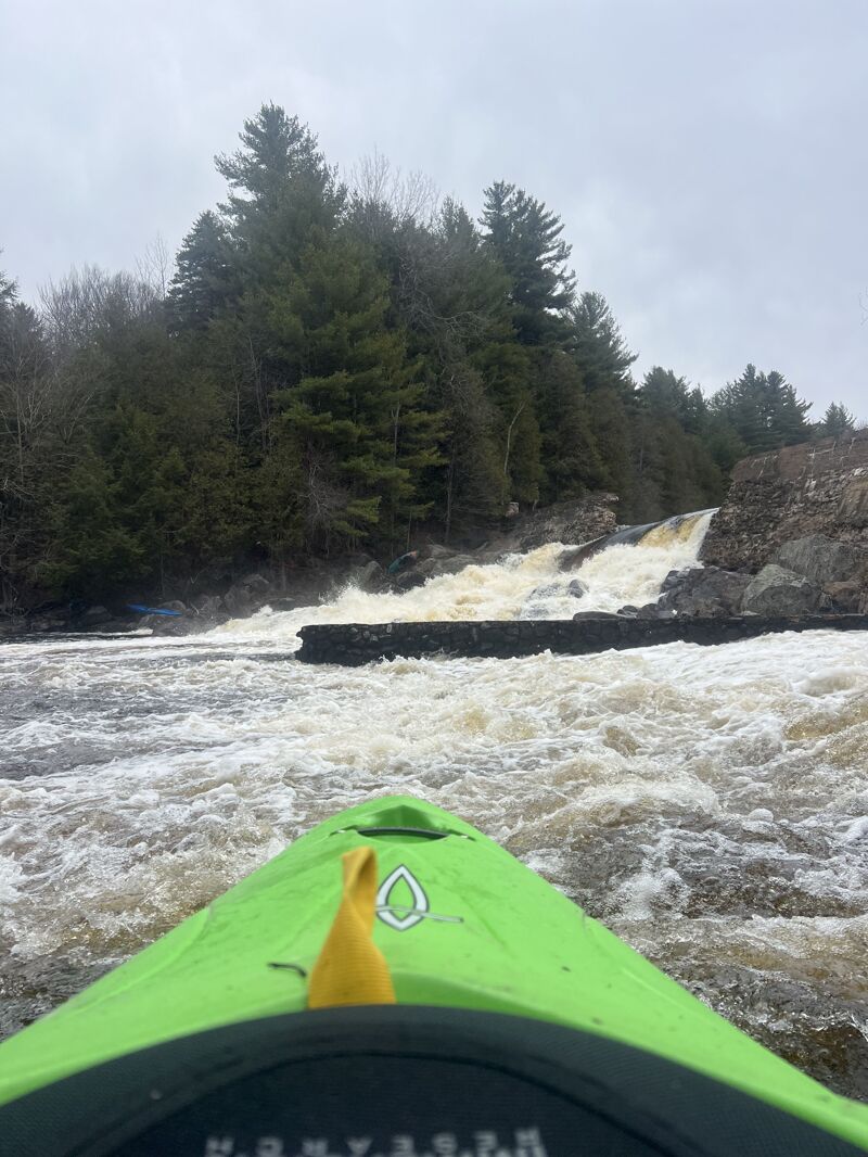
Wilson Mill
OtherClass: III+Distance: 6.5 mi
The water goes around a man made barrier in the river I did not see the right side of the island but the left is a good slide with most of the flow going down the middle and you could go to the far right for a sneak line. the hole at the bottom gets pretty sticky at higher flows.
Bedrock slidin
OtherClass: IIIDistance: 6.7 mi
Below Wilson Mill the riverbed becomes smooth bedrock and there is the most satisfying waves. On one corner, a small tributary creates a scenic cascading 50 foot waterfall into the river on the left.
11B takeout
Access PointDistance: 7.1 mi
Takeout right below the 11b bridge there is a steep grassy slope you walk up to get to the road. do not drop your boat. I parked infront of the church at 637 Water St. with no issues
below 11b
OtherClass: II+Distance: 7.2 mi
Below 11b there is more class III as far as you can see the river and then it peters out into class II then class I before Fort Jackson. In Fort Jackson there is a small gorge class II before the takeout which is a campground on river left. there is also a good play hole on the right at the take out.
Take Out
Access PointDistance: 10.4 mi
Takeout is below the bridge, at a campground, called Fort Jackson Park. 716 Converse Rd. in 2025 I parked next to the bridge in Fort Jackson across from the church and a local was telling me how people used to rip up his grass so he asked that people dont park there.