Little Beaver Creek
2. State Park to Fredericktown(Sprucevale Reach)
| Difficulty | I(II) |
| Length | 6.4 mi |
| Avg Gradient | 10 fpm |
| Gauge | Little Beaver Creek Near East Liverpool Oh |
| Flow Rate as of 54 minutes | 312 cfsrunnable |
| Reach Info Last Updated | March 8, 2007 |
Little Beaver Creek runs from the Lisbon area generally eastward to the Ohio River near East Liverpool. It is the site of the Sandy and Beaver Canal from the canal boom in the nineteenth century and the remains of dozens of the old stone locks are visible from the creek. Beaver Creek State Park, near Elkton, has a rebuilt lock and grist mill, as well as several other restored historical buildings. This park is helpful to the paddler, providing access and parking, camping, and a phone in water level gauge. Another recreational possibility to be aware of is the North Country National Scenic Trail, which passes through the park and along the creek.
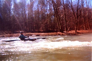
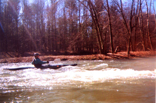
The character of the creek is basically gentle, with slow current and little depth at normal paddling levels. The stream bed is mostly rocky, with serious strainers being a rare occurrence. Class I riffles are found along the length of the creek, with plenty of opportunities to practice eddy cuts & peel-outs. There is only one serious rapid, a class II that approaches class III at higher water levels, found just downstream from the Fredericktown access. This is a good stream for beginner kayakers to learn their water reading skills and to develop the basic surfing/ferrying skills, as well as getting the feel of easy rapids.
ACCESS
The start of this section is at the State Park. To get there exit off route 11 at route 154 and head east towards Elkton. Just past the Elkton post office (on the left), route 154 turns to the left. Go straight here, down CR 419 and continue till you reach the stop sign at route 7. Turn to the right onto route 7 south, and continue about a mile. Turn to the left up a steep hill at the intersection with the brown and white state park sign pointing towards camping. Follow this road up the hill, past the campground on the right, and another mile or so till it comes to a stop sign. Turn to the right at the stop sign, following the gravel road back down the hill. The state park
...May 22, 2014
Thank you Hammock,
If the water level stays over 500 by Sunday I may hit Little Beaver Creek this weekend. First time out this year!
Dear Hammock,
I see you went on April 30th. How was the water and how were you dressed? I am thinking the water temperature was probably 50 - 55 degrees. Were you in a canoe or kayak? I am eager to go but do not have a full wet suit or dry suit.................................................................................................................................................................................................................
On August 9, 2013 (2nd time in the kayak) I took my son, 15, (1st time in a kayak) from Beaver Creek State Park to Gretchen's Lock (Sprucevale Road). The flow was 1100 cfs. It took us a little under an hour on the water for the trip. The water was flowing well. There was one spot near half way were my son was on the left side of the stream and got caught on a bend where the water was keeping him from moving further. After paddling for a little while he finally paddled straight west and caught a current that pulled him out. At no time was he in any danger he just needed to learn to get out of the easy situation. This is the second time from the State park to Gretchen's Lock and the trip is great for beginners. My first trip was with flow at 241 cfs. This was a little low and took 2.5 hrs. We never had to get out to carry the kayak (weight 168 lbs. and stayed right on all splits) but we did feel rocks on the bottom several times. Next post will be when the flow is above 1500 cfs.
May 3, 2014
Andrecg71, The water was cool. I think you are right guessing around 50 degrees or so. We had on our farmer john wetsuits with boots and were glad we did because of the cool weather. If the air is warm and the sun is shining I'd say go for it without the wetsuit. We were in our kayaks and really didn't get that wet although the river was running kind of slow that day.