Little Beaver Creek
2. State Park to Fredericktown(Sprucevale Reach)
May 22, 2014
Thank you Hammock,
If the water level stays over 500 by Sunday I may hit Little Beaver Creek this weekend. First time out this year!
Dear Hammock,
I see you went on April 30th. How was the water and how were you dressed? I am thinking the water temperature was probably 50 - 55 degrees. Were you in a canoe or kayak? I am eager to go but do not have a full wet suit or dry suit.................................................................................................................................................................................................................
On August 9, 2013 (2nd time in the kayak) I took my son, 15, (1st time in a kayak) from Beaver Creek State Park to Gretchen's Lock (Sprucevale Road). The flow was 1100 cfs. It took us a little under an hour on the water for the trip. The water was flowing well. There was one spot near half way were my son was on the left side of the stream and got caught on a bend where the water was keeping him from moving further. After paddling for a little while he finally paddled straight west and caught a current that pulled him out. At no time was he in any danger he just needed to learn to get out of the easy situation. This is the second time from the State park to Gretchen's Lock and the trip is great for beginners. My first trip was with flow at 241 cfs. This was a little low and took 2.5 hrs. We never had to get out to carry the kayak (weight 168 lbs. and stayed right on all splits) but we did feel rocks on the bottom several times. Next post will be when the flow is above 1500 cfs.
May 3, 2014
Andrecg71, The water was cool. I think you are right guessing around 50 degrees or so. We had on our farmer john wetsuits with boots and were glad we did because of the cool weather. If the air is warm and the sun is shining I'd say go for it without the wetsuit. We were in our kayaks and really didn't get that wet although the river was running kind of slow that day.
Apr 30, 2014
We were doing the Sprucevale to Grimms Bridge section on 4-29-14. The flow was about 500cfm. Just past the horse park at the S turn there was a tree across the river at the first turn. Portage is on the rivers right. Immediately after the S turn there is another tree although the river was low enough we were able to get under that one. Otherwise the portage would be on the rivers left to get around that one. I see that the flow is way higher today and climbing so I don't know what that will do to the obstructions. Shortly downriver from there we saw an amazing gathering of bald eagles! A total of eight, one adult and 7 juveniles all together in the same stretch! Awesome! One of the juveniles swooped down and wacked the head of a blue heron. Quite the sight. The ride took about 3 hours.
Jun 27, 2008
Paddled this on June 26th. Flow was about 400 cfm. Not very deep through entire run. We are new to Kayaking but this was very fun for us. We didn't really have to paddle much if we didn't want to, we even fished quite a bit through the slower areas. We put in at the place in Elkton and took out right before Gretchens Lock. Entire trip took 3.5 hours. I am thinking of taking the kids and putting in at the same place and take out at Lusk Lock, it should only be 1 or 1.5 hours for this (I think). There was a tree across creek about 20-30 minutes before the Gretchens Lock Bridge which we were able to go under, but this may be a problem if water was higher.
Did this again this spring 2010, the tree across the river is gone. the water was about 500cfm and it took about 4 hours but we paddled most of the way and didn't fish at all. Should have taken out at Gretchens lock ( where we did last year) and not at sprucevale bridge. It is a good area to take out because the last half hour or so was too long for us.
Jun 10, 2007
STRAINER WARNING. About 1 mile downstream from the Sprucevale Bridge, the creek cuts a hard right corner which looks like it disappears. Approach the corner with caution as it collects strainers, and root-balls. A portage may be necessary (river left). Coordinates N 40.72°, W 80.57° (WGS84), Rough Run enters just upstream of this point.
Jan 1, 1900
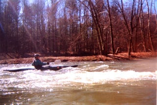
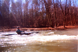
Me surfing my old Pirouette on the Piano wave.