Tohickon Creek
3. Ralph Stover State Park to Point Pleasant (PA Route 32)
| Difficulty | III |
| Length | 3.4 mi |
| Avg Gradient | 42 fpm |
| Permit | The state wishes to sell day permits at the put-in during the release. You probably won't need this if your boat is stickered with the PA fish and boat commission yearly permit. The takeout parking (Bucks County River Country) has been $10 for one day and goes to the local fire department. Running shuttle to the lot has been free in the past. Overnight camping and porta-potties are available there also. |
| Gauge | Tohickon Creek Near Pipersville, Pa |
| Flow Rate as of 26 minutes | 8 cfsbelow recommended |
| Reach Info Last Updated | April 2, 2024 |
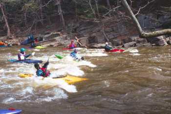
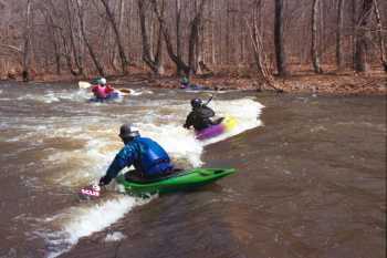
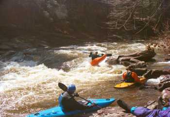
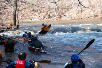
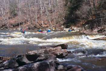
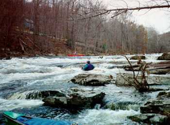
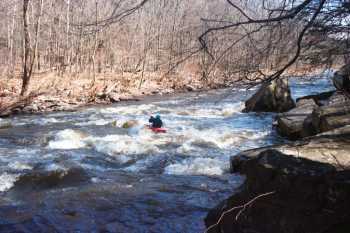
Typically releases are scheduled for March & November. Hope to see you there! The Tohickon is a jewel to us locals. It offers some great play, scheduled releases, and lots of activity after heavy rains. It is a good Class III run that can be viewed as a stepping stone for novice and intermediates or as a fun play creek for intermediate and advanced paddlers. There is a fun play hole that serves up some great surfing and verticality to those that are patient. There are at least six challenging rapids in this 3.75 mile stretch that will keep anyones attention. Scheduled two day releases are generally the third weekend in March and the first weekend in November. Ralph Stover State Park. Some changes the state is making is to require launch permits, either daily permits sold at the park on release days,or state fishing/boating permits. Actual implementation of this is still in progress. For more information, see Keystone Canoeing by Gertler
Small surfing wave river left upstream of the bridge.
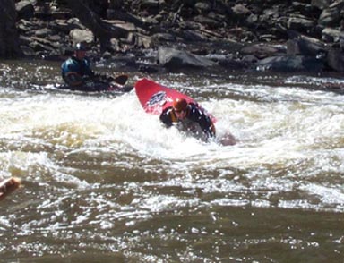
A large sticky surfing hole on river right, with a surfing wave in the center right next to it. There is a small eddy on the right, and a large one on the left. Just below on the left is a small friendly side surfing hole.
Down past the rock climbers at High Rocks is 'Corner Hole' (a.k.a. 'Diagonal Ledge'). A surfing hole on the left, with an eddy below and above. The left side of the hole is a little sticky and pour-over-ish, but its easy to get out the right side (and then some power stroking to get back into the eddy). There is a nice surfing wave below and to the right of the hole.
After some small ledges is the 'Chute' (a.k.a. 'Flume', a.k.a. 'Chainsaw'). There are boofing rocks with a micro eddys behind them on the right or left, with a big eddy below the chute on the left. Nice surfing waves in the center. 100 yards below is a small ledge with an eddy to its right, with a squirtable eddy line.
Some more small ledges and waves leads to 'No Name Ledge.' This is a small single drop which can be run down the center, or thru a slot on the right. The right side slot can give rocky popups to short boats. A side surfing hole is about 100 yards below on the right.
The fun starts with the next rapid, 'First Ledge.' This can be run center-right over some pillows down thru a surfable wave/hole (the 'Green Monster'). Alternatively you can eddy out left after the first little drop, and then ferry right (with a couple of stops to surf waves) and down to the wave/hole. Or you can run more of a sneak route to the far right down the first part of the drop and the move quickly left towads a rooster tail hole. Then pick a number and get in line to surf the hole (the 'Green Monster').
A quick pool to catch your breath, and you come up to 'Second Ledge.' This is a two part drop (this ledge and the one above is is also called 'Triple Drop'). The first river wide ledge can be run to the center right, and then down to the right of the washed over rock at the bottom. Or you can run a chute on the center left of the first drop, eddy out in the pool, and either then ferry over far right or thread the needle to the left and then behind the washover rock (a raft snagging rock is ready for you if you don't cut behind the washover rock).
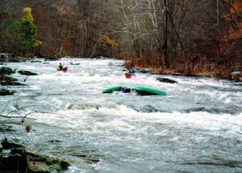
Another pool brings you to the start of the area used for slalom races back in the old days - the 'Race Course.' You can enter on the left, and stay middle left down past rocks and ledges to the end of a small island, at which point you want to be far left. Or, you can catch a slot to the right of a washed over rock in the center at the top of the rapid, and then down to a surfable hole on the right. Head left after the hole to the end of the island, and then down thru a nice wave train in a fairly narrow section. Eddy out at the bottom.

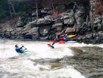
The last big drop is 'Hat's Rock' (a.k.a. 'Ricki's Rapid'). Scout it from the left shore to be sure to catch all the good spots on the way down. You can enter it on the right past a line of irritating small rocks, then down through waves and a couple holes on the right side. Keep the big rock to your left at the bottom.
For the more adventurous, you can enter it at a small chute left of center of the first ledge on the left side with some left to right momentum. Spin your boat and drop into the hole facing the left side. Back out of the hole and ferry over right to drop into two holes in the center of the drop. If you come out of the left side of the first hole, you are in for an interesting ride through some slots down the left side of 'Hat's Rock' (especially if you are in a low volume boat). Or you can hit the far left side of the first ledge and spin into the eddy on the left shore. Then ferry over to the right, punch the holes, maintaining your right side momentum to reach the right side of 'Hat's Rock.'
Below this drop is a rather sticky hole along the right shore, and then the last gasp of the Tohickon, 'Pyramid Rock' (a.k.a. 'Ships-Prow'). Aim just a shade to the left of this rock which is just off the right shore, brace off some steep pillows, and shoot past the rock. Or, eddy out on the right shore just above the rock, and ferry over into the pillows above the rock. For the less adventurous, it can be completely snuck by staying left.
You can take out a a small river side park just above the bridge (but don't stop traffic by parking on the road), or head down below the aquaduct bridge to a pay takeout at a local outfitter. Or you can continue out to the Delaware and take out at various points along the river.
Sep 21, 2020
The co-ordinates are wrong. The put in is actually on the other side of the bridge at 40.434594, -75.098087. Also, the bridge is closed so you can't drive across.
Jun 4, 2019
We ran this at 210 cfs, which is considered below recommended. Personally, I now consider 200 cfs, possibly even lower, as my minimum. It channelized very well and all of the rapids were easily runnable.
Nov 5, 2018
The Toe can be run at higher levels. We ran it at 2700 cfs two days ago, and while the character of the river changes, it is still a Class 3, although it is more challenging than at release level. There are lots of fun wave trains, the rapids are long and continuous, and the water is up in the trees. A swim would be long.