North Chickamauga Creek
2. Walden Ridge to Soddy-Daisy(North Chick)

Apr 8, 2013
Here is link to video of the Chick at 3.8ft on the boater gauge.
We put in on Cain Creek below the big ones. I believe the put-in was called rock house.
Dec 11, 2009
As of 12/10/09, the usgs gauge used on this site is not accurate. Ran it on 12/11/09 at 2.6 ft, while the online gauge read 1.8 cfs.
Mar 27, 2009
This rapid is on North Chick somewhere above North Chick Falls
This rapid is somewhere above North Chick Falls
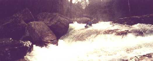
This is the entry rapid to North Chick Falls.
North Chick Falls
North Chick Falls
This is not the most difficult rapid of the run, but it is the most scenic.
I am not sure but I think this rapid is known as Baby Sweets.
Aug 25, 2005
WARNING: BAD SIEVE
We almost lost a good man to the sieve below the hole at El Roberto on 7/11/2005. Although he had to buy us all beer that night for saving his life, I would prefer to buy my own. I am posting this so nobody else will take this rapid as lightly as we did yesterday. Our party of 6 had a combined 25+ runs on this river and I think that we let out guard down in what seemed to be a fairly innocuous spot. We put on around 12 at about 6.2 on the USGS gauge. The Bowater Gauge read 1.5 when we put on and 1.35 when we took off. The sieve is created by the huge boulder that the author of this picture is standing: http://www.americanwhitewater.org/photos/?photoid=7891
This photo (which can also be seen above is labeled El Roberto by Rob Maxwell) also illustrates the typical line through the rapid: punch the upper corner of the hole and eddy out on river left---avoiding the meat of the hole and the large tree obstructing the narrow exit on river right. From the eddy, you ferry between the backwash of the hole and the truck-size boulder that is blocking half of the river---threading between the boulder and the tree. At higher water, this is an easy move because the eddy is large and the water is pillowing off the boulder. At lower water, the boulder's undercut is exposed and the eddy is small, shallow, and leaks directly into the undercut left side of the boulder with tremendous force. Most of the party had eddied out and the fourth guy (I will call him Lazarus) hit the leaky part of the eddy and began to slip away. He went for the ferry around the rock but didn't make it over the pillow and was sucked into the undercut. He completely disappeared under the rock and at one point we could only see the 18' of his stern. He sprung out from under the rock grasping for purchase but went back under before we could grab him---fingernails scraping down the rock as he went under. While he was down there talking to Jesus, we were there instantly to pull him out with ropes or whatever it took if he surfaced again. He did---and we were able to grab both arms and it took all of us to pull his ass out from under the boulder. Lazarus later explained that it was about 12 feet deep under the rock and very dark. He said that he wouldn't have had the energy to crawl toward the light a third time. I honestly don't know how he was able to manage it twice but he is a wicked strong mf$@%@&.
The main thing I learned that day is to take nothing for granted: paddle down every river as if it were my first run. The other lesson learned is that maybe I will boof the flake next time and take my chances with the hole and tree dance.
Jul 15, 2005
WARNING: BAD SEIVE
We almost lost a good man to the sieve below the hole at El Roberto on 7/11/2005. Although he had to buy us all beer that night for saving his life, I would prefer to buy my own. I am posting this so nobody else will take this rapid as lightly as we did yesterday. Our party of 6 had a combined 25+ runs on this river and I think that we let out guard down in what seemed to be a fairly innocuous spot. Our party of 6 put on around 12 at about 6.2 on the USGS gauge. The Bowater Gauge read 1.5 when we put on and 1.35 when we took off. The sieve is created by the huge boulder that the author of this picture is standing: http://www.americanwhitewater.org/photos/?photoid=7891
This photo also illustrates the typical line through the rapid: punch the upper corner of the hole and eddy out on river left---avoiding the meat of the hole and the large tree obstructing the narrow exit on river right. From the eddy, you ferry between the backwash of the hole and the truck-size boulder that is blocking half of the river---threading between the boulder and the tree. At higher water, this is an easy move because the eddy is large and the water is pillowing off the boulder. At lower water, the boulder's undercut is exposed and the eddy is small, shallow, and leaks directly into the undercut left side of the boulder with tremendous force. Most of the party had eddied out and the fourth guy (I will call him Lazarus) hit the leaky part of the eddy and began to slip away. He went for the ferry around the rock but didn't make it over the pillow and was sucked into the undercut. He completely disappeared under the rock and at one point we could only see the 18' of his stern. He sprung out from under the rock grasping for purchase but went back under before we could grab him. We were there instantly to pull him out with ropes or whatever it took when he surfaced again. We were able to grab both arms and it took all of us to pull him out from under the rock. Lazarus later explained that it was about 12 feet deep under the rock and very dark. He said that he wouldn't have had the energy to crawl toward the light a third time. I honestly don't know how he was able to manage it twice but Lazarus is as strong as a horse.
The main thing I learned is to take nothing for granted: paddle down every river as if it were my first run. The other lesson learned is that maybe I will boof the flake next time and take my chances with the hole.
Mar 17, 2005
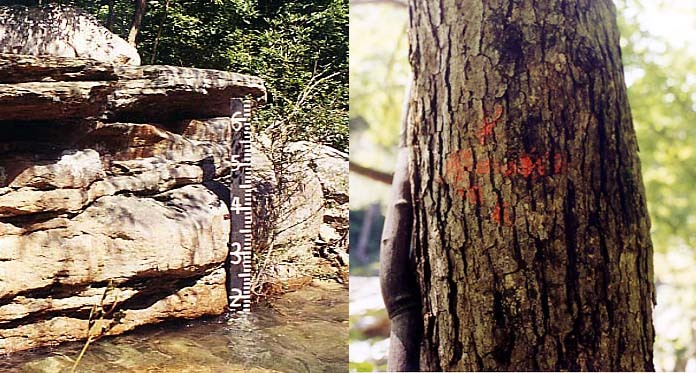
The USGS North Chick gage is in an unstable stream bed that changes and shifts after floods. Lucky for us, the Bowater Paddler's gage is placed in a very stable area and hasn't changed with each flood. As of December 2004 here's how the USGS gage relates to the Paddler's Bowater Gage.
USGS = Paddlers Gage
10.93 = 5.50
7.68 = 3.25
7.23 = 2.90
6.92 = 2.80
6.84 = 2.50
6.57 = 2.20
6.30 = 1.80
6.27 = 1.75
6.16 = 1.50
6.14 = 1.10
I have an Excel 2000 spreadsheet that predicts the levels for North Chick and several other rivers in the southeast. If you
Nov 23, 2004
Since the last time I checked this page out someone added some good pics. One of the rapids in the pics that the author called 'Truth or Concequence' is actually named 'Back Street Ally'. This is always a good one to scout. Over the years I have seen all sort of trees stuck in this one.
Nov 8, 2004
The internet gauge is now way off. UPDATE: I ran it the other day at 6.17 on the Online gauge which was 1.5 at Bowater and just under 0.5 at the top - I would consider this bare minimum to run from the top of Cain, though some would say minimum is a little higher. It can be run lower if you putin at drainpipe(down to maybe 1.1 on the bottom gauge if you don't mind banging on a lot of rocks). Careful if you put on at Drainpipe - someone slashed my tire there in 9/04.
Mar 8, 2004
More N. Chick History:
Bob Slayden, David Broemel, Greer Edwards (Broemel), Ken Strictland, Charlie Sturdivant ran from Rock House on Jan. 19, 1980. Minimum water level. Ran Falls, but rocky. Greer washed over the falls, but OK. Water level about minimum. My notes say that N. Chick. was first run in Nov. 1979 by Mike Stoker and Lewis Brawley. Second run was in December by Roger Scott, Ken Strictland, and Tom Parsons. All runs were from Rock House.
We started putting in off a surface mine road that required extensive 4-wheelin to get access. This point is about 1 mile downstream from the Greyfrier Road access. My recollection is not getting out of the boat for the entire run once we leared the routes. Ran it 4-5 times in early 80's. Great Creek. Still my very favorite. --Bob Slayden
Feb 23, 2004
From Clay Wright:
N. Chick:
Internet gage is easy now days . . .AW site rules! Cain side much more popular now . . why miss Vortex and Drainpipe? Shorter, too. More write-up needed on Walden
Jan 10, 2004
When the North Chick Gauge is at 2.8 you can put in at Hixson Springs Creek along the powerline in the state natural area and paddle down to North Chick. This will put you in right above Mystery Falls. The hike to Hixson Springs Creek is about 30 min. Park at the new parking area for the natural area on Hixson Springs Road. At levels below 2.8 you will probably have to walk down the creek bed to North Chick but it is not far. This access keeps you off private land and allows you to cut out the flat water.
Feb 19, 2003
From Ted Hayes
Here the beta.
Old 27 S (Dayton Pike)
Lft @ Falling Water
Go up Roberts Mill
Bear Lft @ Sawyer
Rgt @ Corral
Rgt @ Grey Frier
Dead end Street.
\* No Public Parking *
Ask permission to park, locals were boater friendly.
Follow the drainage ditch off to the lft, it straight
to the creek.
Alot of flat water, some cool drops. Especially
Mystery Falls, overall a long day. Recommended when
the Chick is on the high side, and relatively warm. No
sure of the actual mileage, but I do remember it being
a pretty long paddle. There is a trail, according to
Terry Smith. When I get more info, I'll let you know.
Feb 18, 2003
From SEboater on Boatertalk:
1'7 - 2'2 low to med low
2'3 - 2'7 med (on avg)
2'8 - ? pushy, big holes, fun
Jan 20, 2002
One of the many nameless rapids on the 9 mile long North Chick.
One on the many nameless rapids on this reach. This is just below Mystery Falls.
Jan 2, 2002
Milt Aitken runs Mystery Falls on the North Chick. The level was 6.35 feet on the new online gauge.
Jan 1, 1900
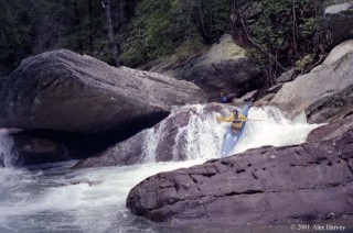
See more pictures of this run, including a larger-sized copy of this picture, at [http://www.alexjharvey.com/Tennessee.htm#North Chickamauga]( http://www.alexjharvey.com/Tennessee.htm#North Chickamauga).
Jan 1, 1900
Jiri lacks the balls to run it down the gut at high water.
Jan 1, 1900
Milt Aitken runs welcome center. The first major rapid on North Chick.
This is the second or third rapid after Welcome Center.
Mystory Falls gets its name from the almost guaranteed mystery move you will do at the bottom of the falls. Well, that is if you aren't paddling a 14 foot Caption like Steve Frazier.
Milt Aitken runs Baby Sweets.
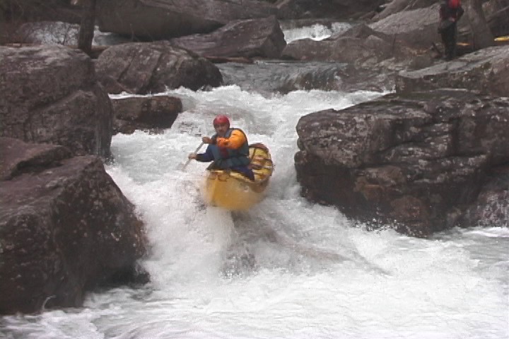
Chris Gorman running 8 Ball, the first Class III rapid on North Chick.
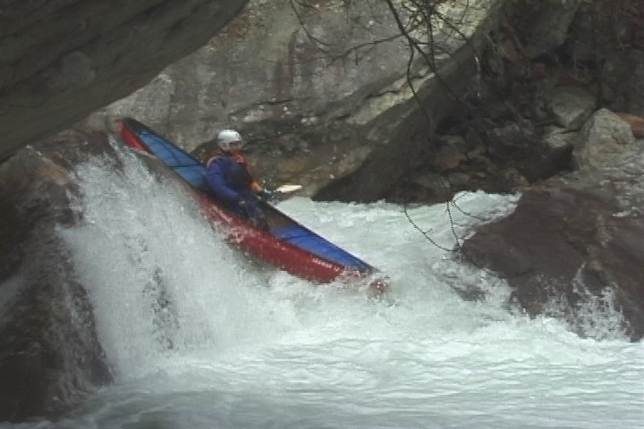
Jim Strickland doing a nice boof at Mystery Falls.
Chris Gorman running Cyclops. The rapid gets its name from the hidden peton rock, smack-dab in the middle of the hole just to the right of Chris.
Peter Horne running 8 Ball, the first class III rapid on North Chic
Mike Ferrell running the far right line on Cyclopse.
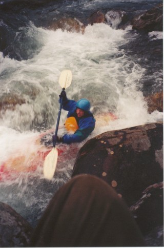
Tarp George running El Roberto.
Tarp George running Mystery Falls.
This would be a much nicer shot if Sutton would just put his arms down... it would smell nicer too.
Mike Ferrell running Triple Drop.
'V' Ledge has a very powerful hole on river right. The object is not to go there! Will does a nice job avoiding the hole and making 'V' Ledge look easy.
Truth Or Concequences is one of the few rapids on North Chic that has serious penalty points. Just over Tarps right shoulder is the worst seive you will see on North Chic.
Finding the paddlers gage is a little tricky. First enter Bowater Recreation area and drive until you take the hair pin left turn. After the hair pin, there will be a parking area just down the road on your right. Park there and walk down to the river. Walk upstream on the trail about 30 to 50 yards. Watch for a tree with an orange arrow painted on it. The arrow points the way to a short path that leads to a large flat rock by the river. Stand on the rock and look down. You will find the gage below your feet in a calm eddy.
Peter Horne running the last drop of Double Drop. Behind him you'll see the first drop.
Jan 1, 1900
This rapid can be run either left of the big bowling pin rock or right...more moves to make on the left line, but right has a pretty sticky hole.
Jan 1, 1900
smoothio
Jan 1, 1900
Goto http://filebox.vt.edu/users/cdgorman/index.html for more SE creeking videos
Jan 1, 1900
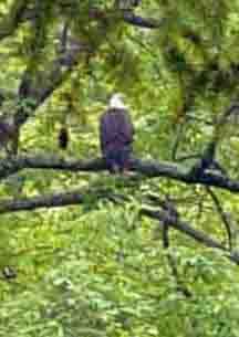
this is one of the bald eagles that call the north chick gorge their home
Jan 1, 1900
This is a great class II/III run with one IV...lots of play, beautiful water, and easy access.
Great level, beautiful, cold day.
This rapid can be run either left of the big bowling pin rock or right...more moves to make on the left line, but right has a pretty sticky hole.
This is a great rock for righty splatwheels, I call it Shawn rock because he can pretty much stay there all day.
Jan 1, 1900
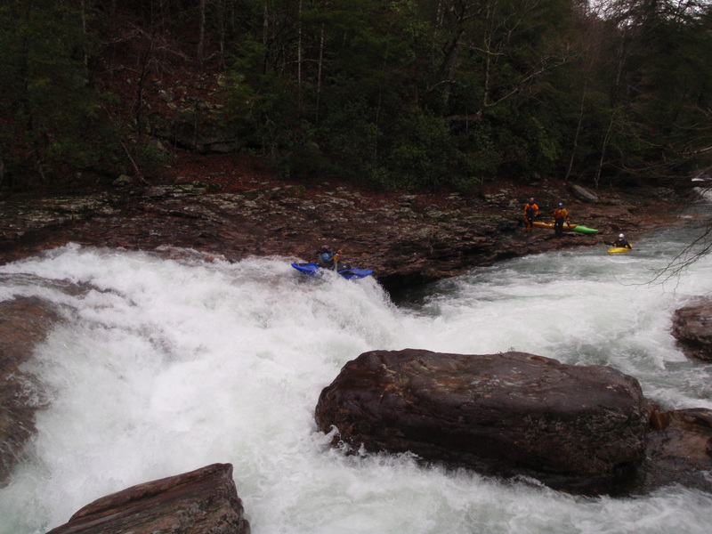
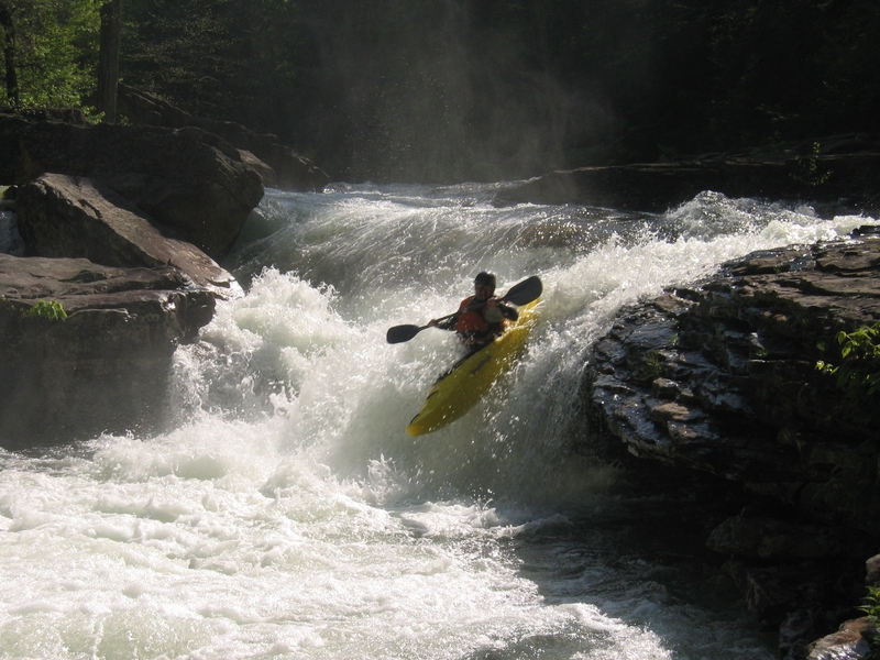
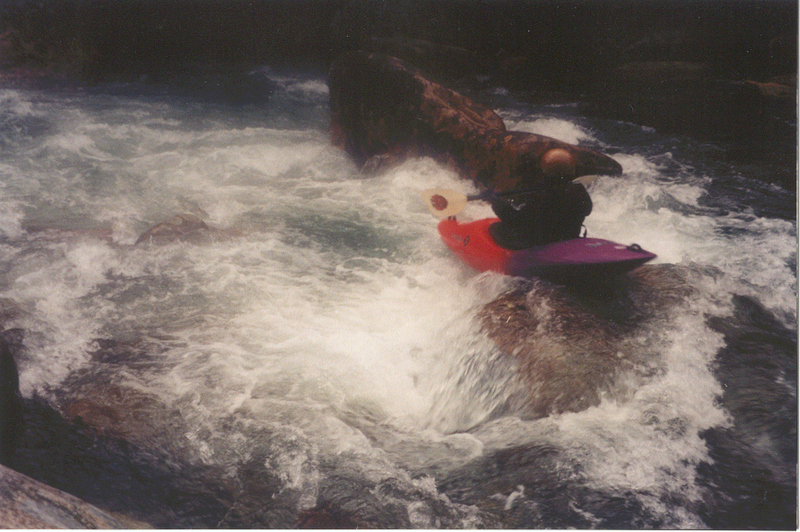
Nate Helms goes for the mighty north chick falls. Get some speed, and stay a few feet from the top rock on the right. After the first drop, the pillow/curler will push you a little left and on down the next few feet. If you don't have enough speed you could get pushed into the undercut on river left, which is the bedrock shelf lower right in the picture. optional run at high water is riding the river left bank. Many people run the river right side of the island instead of this.