Ocoee River
Middle Ocoee - #2 Dam to #2 Powerhouse(Lower Whitewater Section)
| Difficulty | III+ |
| Length | 5.5 mi |
| Avg Gradient | 50 fpm |
| Reach Info Last Updated | July 10, 2026 |
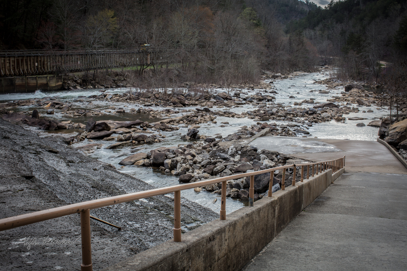
Originally managed by the Eastern Tennessee Power Company, the Ocoee River was dammed to build hydroelectric plants. The Ocoee No. 1 and Ocoee No. 2 Dams were built between 1910 and 1913 featuring wooden flumes that divert the waters of the Upper and Middle Ocoee along an elevated path before they drop into the hydroelectric powerhouses. The Tennessee Valley Authority (TVA) purchased the power system in 1939. In September 1976, the wooden flume diverting water on the Middle Ocoee was shut down for reconstruction and the river ran unabated. The river attracted lots of attention, as boaters flocked to the Middle Ocoee to run its five miles of continuous whitewater rapids. Rafting companies sprang up while the TVA hurried to repair the flume to again divert water from the Ocoee. After much resistance and a Congressional Act, TVA agreed to schedule 116 days of recreational whitewater releases per year on the Middle Ocoee. Whitewater racing events have been held on the Ocoee since 1978, bringing the river to the attention of the world. The Ocoee has also been called the birthplace of freestyle kayaking, hosting the first-ever Ocoee Rodeo at Second Helping in 1983. The Ocoee has become one of the most popular whitewater rivers in the world, attracting over 250,000 visitors annually.
The Middle Ocoee's numerous rapids and river formations offer a wealth of currents and surf for creative and skilled paddlers. Class III for its entirety, the Ocoee requires at least strong intermediate skills and a solid river roll for a successful run. The action is fairly continuous from top to bottom, letting up only for a half-mile known as the Doldrums. The top section (from the dam to the Doldrums) is a little harder than the lower section (from the Doldrums to the lake). Many first-timers opt to put in halfway down at Goforth Creek to get a good taste for the river before tackling the full run.
Launching from the put-in at the base of the dam, you immediately begin the f
...The Middle Ocoee Put-In is really well laid out. There is the main preparation area near the main bathhouse, pavilion, and roundabout. Private boaters often unload in the parking spots found on the right side of this lot and then move their vehicles to the parking found adjacent to the roundabout. There is ample parking and rarely a need for overflow. Note that rafting outfitters use the roundabout to pull buses up and unload their rafts, gear, and guests -- don't leave your gear hanging out over the curb! From the loading area making your way towards Ocoee Dam No. 2 there is a wide ramp leading down to the put-in. Commercial rafts and private boaters must all share this area, usually seeing 3 rafts lining up next to each other on the second ledge and allowing space on the right side for private boaters to setup. The ramp has a 2-foot step down to a secondary ledge where boats can stage to launch, this often has shallow water over the ledge and more-so on high water releases.
Grumpy's Ledge is rated Class III+ between 1,200 and 1600 cfs. At higher flows Grumpy's Ledge really deserves respect. To run this rapid clean make a nice controlled peel out from the ramp eddy. Then follow and ride the current to just left of White Face Rock. Beware getting to close to pyramid rock as there is a shallow rock lurking there.
North Shore is a fun and easy Class II+ rapid located just below Grumpy's Ledge. Easy boogie water just follow the flow gradually working from left to right. It names is derived from the fact there is a sweet wave trough for hard boater and several surf able waves. There is a spot or two to surf a raft as well.
Staging Eddy is easy Class III you will eddy out your raft river left to regroup. The opening feature of this rapid is called Power Flow a great surf spot for hard boats. While awaiting the rest of your trip get in line to surf the fun hole in the center of the river. Be careful not to break ranks with another company's trip that is already surfing. Try to be courteous to kayakers in the river right eddy.
Gonzo Shoals is Class III but very shallow with multiple gate rocks. You will begin near the center of the river as you leave Staging Eddy. Follow the flow somewhat toward the left of center before working back towards the huge Gonzo Shoals Rock near the center of the river. There is a marker rock to thirty feet or so from the big rock. Pass it just to the right and follow the main flow over a ledge and work your way left with the flow to the bigger double ledge. Your main concern and primary hazard of this rapid is getting flat pinned so pay attention.
After dropping the largest ledge in Gonzo look for the lurking gate rock just down stream navigate them and work towards the right thirty or forty feet to towards the flow headed to Good Luck Rook. Be alert the line is narrow and rafts tend to bunch up and get stuck here. As soon as you pass Good luck rock begin heading river right and following the flow. Don't be lazy here or you will pay! You will be about 30 feet from the river right bank as you begin the approach to Broken Nose.
Broken Nose is rated Class III+ between 1,200 and 1,600 cfs. The approach is shallow so look for the green water and avoid rocks. Pile up occur in the approach. If you get stuck senior guides will have no mercy! Be aware of the shallow rocks in the approach. Meet the seam in S-wave square and maintain your left boat angle with a right draw stroke (lefties will use a pry stroke) as you drop into the breaking wave. Don't point at the river right bank. If you get hung up on the rocks along the river right banks because you failed to maintain left boat angle Look Upstream.
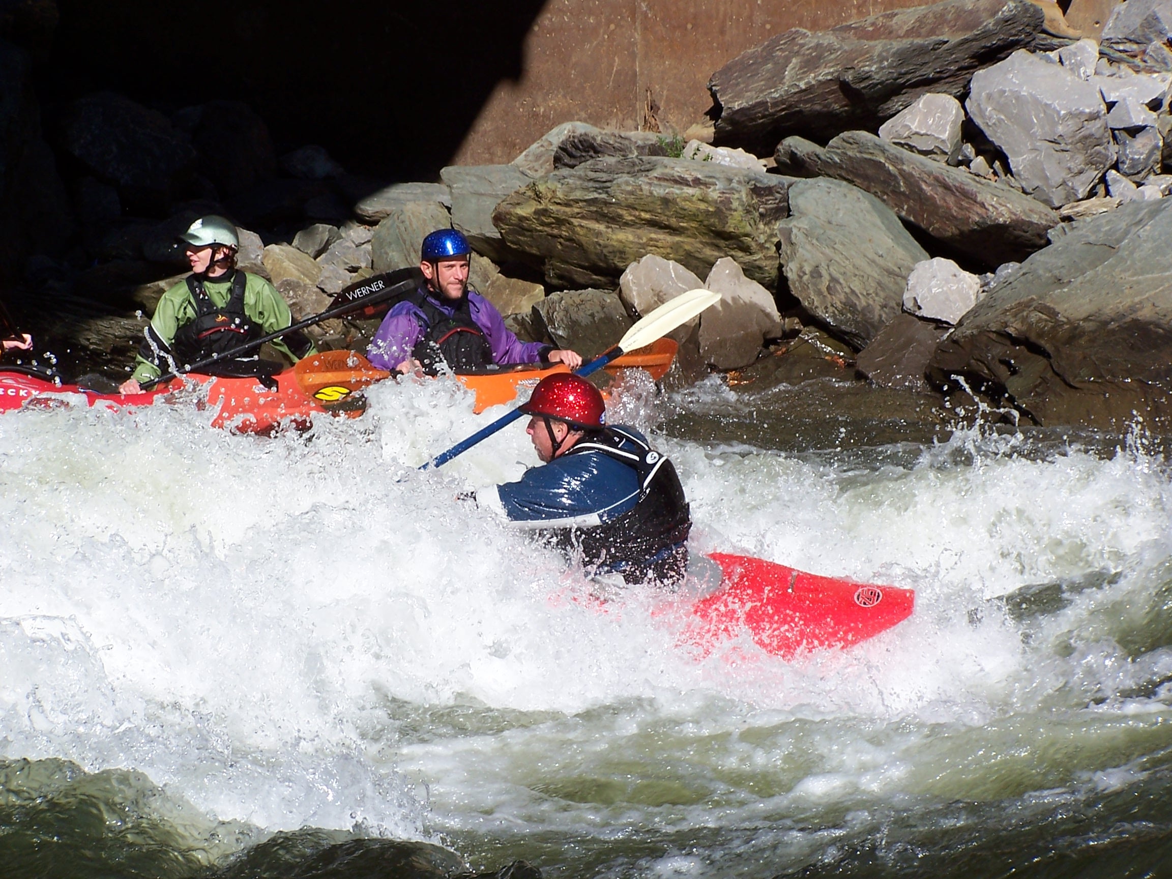
Slice and Dice is rated Class III. Beware swims here can be nasty. The rocks lurking at Washing Machine are sharp and the rapid lived up to its name! The opening move is either dropping the big ledge called Dragon Slayer just left of center. Watch the video carefully for cues. There is a bad hazard called Ankle Breaker if you drop the ledge too far left. Be careful not to lose guest dropping this high ledge. If someone pops out make sure you recover them ASAP! As mentioned above swimming Washing Machine is likely to create injuries. If your ran the ledge successfully and quickly work right and point upstream you will see a surf opportunity.
Alternately there is a ramp move closer to the river left bank to avoid the big ledge. If you take this route follow the current. You will angle right and charge between gate rock as your drop a smaller ledge.
After successfully running either of these options you will head toward the center of the river to run the obvious tongue through Washing Machine. The sticky hole will be to your left. This part of the rapid is made up of offset holes. There are some great splash opportunities in the run out. Watch for kayakers in the shallow river left eddy or better still catch the river right eddy and regroup with your trip.
Moon Chute is a rated Class III. It is super fun and great place to spin. It is possible to enter this rapid in front or behind Elephant Rock; if you have a really weak crew consider the right line behind the Elephant. Spin on the eddy line or at least use the eddy line to avoid pinning to the left of Butt Crack Rock. If blow the line and go left Butt Crack Rock aka Dark Side of the Moon don't panic. There is an escape route look for the current leading left of the island and commit! Ask you trainer about this option and maybe they will show you.
Assuming you successfully made the move right of Butt Crack Rock follow the flow and stay toward the river right side of the final chute. Look for shallow rocks to avoid. You really want to follow the green water here.
Multiple entrance moves, there is a straight forward line on the river right side, yet somewhat more shallow than the left entry. The left line curls around a rock known as 'Alligator Rock' where water level can be eyeballed. Both lines meet up on the river right side at a small ledge and then move towards the center of the river to drop over the ledge into Double Suck. Known for it's 2 hydraulics as a great surfing spot and a bad swimming spot, Double Suck is a small waterfall into a hole. Often times rafts will gather in the eddy behind the large rocks in the center of the river to queue for surfing the second hole. Hard boaters will often queue in smaller eddies on the river right where there is also a skirt line around the holes and still boasts a fun drop.
Class II boogie water between Double Suck and Double Trouble, fairly shallow but lots of small lines in and around the rocks. Not actually half a mile, just feels that way if you swim this section. Do note that rafts do not run the river left side of the island after Double Suck, however they will eddy out behind the big rocks at Double Suck to surf in the hole.
Ending Hell's Half Mile is Double Trouble, two holes with good sized waves. This is a big photo spot for a lot of the outfitters and this is where the photo spot is for private boaters through Ocoee Photos. There is some surfing and playing to be done here in kayaks, usually from the river left eddy. There is also a undercut rock on the river left side, it's the only one protruding from the shore so you can't miss it.
Shortly after Double Trouble, Jump Rock appears on the river left side with a tighter channel on the left and the wider channel in the center. This is often a regrouping spot for outfitters who will take up the river left eddy in it's entirety. Outfitters may also have rafts overturned on the river right side of Jump Rock acting as a slide for their guests into the main current, watch for swimmers and throw ropes that have been tied to the end of rafts and let out.
Just downstream from the Jump Rock eddy begins Left Right Left, this is a fairly simple rapid and named for the commercial rafting line moving from the river left side, to just right of center, and then making their way back to the river left side in preparation for Squeeze Play. There are play waves, smaller holes, and tighter lines within the more shoalsy river right portion at the start of this rapid.
The second part of Left Right Left where rafts will start heading back towards the river left side, boasts 2 surf holes in the center of the river. Honey Hole is a smooth pour over hole that is a relatively calm surf and out of the way from the commercial line. Line of Fire is the surf move on the second waves of the ending of Left Right Left on the player's right side, this one is 'in the Line of Fire' of the commercial rafting line. Some guides will also surf their rafts in these two spots.
Squeeze Play aptly named for the main channel being pushed into the river left bank is a fairly easy rapid with a nice wave train to follow, there is another line to the right of Squeeze Play rock. The commercial rafting line is to the left of Squeeze Play rock in the 12-15 foot channel. Squeeze Play is also a pinning spot for rafts who run dead sideways into the upstream side of Squeeze Play rock.
Flipper is a river wide ledge that creates an amazing surfing spot for all boats, most private boaters run just left of center and make their way into the river left eddy to stage for play. Commercial rafts will surf here as well if the guides are experienced enough to handle it, it's a great spin surf for those rafts - Otherwise the commercial rafting line is right of center with a right hand angle to cruise just left of Flipper rock which is underwater on the downstream side of the ledge about 12-15 feet from the river right bank. Flipper rock is a potential flip hazard for rafts that run directly into it. There is a skirt line on the river right side against the bank in which both the ledge and Flipper rock are avoided, but it is a hard ferry to get across to the Flipper eddy on river left if you take this line.
Nestled in the center of the river and poking out of the water straight up is Oh Sh** Rock or 'OSR', this is mainly a pin hazard for rafts and can easily be avoided with the right line through Flipper. There is ample time to make it to either side of OSR after running Flipper and while the river right channel is a less obstructed path, it contains 2 waves and will then require a move to the river left side for Hollywood. The left channel at OSR is fine for either rafts or kayaks/canoes, but has a tighter line with more rocks and is not the recommended commercial rafting line.
Hollywood Hole is a great surf spot in the center of the river, the main line and commercial rafting line is along the river left side and left of Hollywood Hole. Many rafting companies will surf here, some guides can manage a spin surf while others are in and out quickly. The river right eddy is the place to stage for this feature just downstream of Hollywood Hole. Running the river left channel will make it harder to get to river right again as you take the wavetrain into the Doldrums.

Beginner (or other less confident/aggressive) boaters may bypass some of the tougher rapids by putting in here.
After floating through the Doldrums you will pass the tunnels underneath the bridge to GoForth Creek. As you pass this landmark you are entering Hiwassee Shoals, named after the Hiwassee river just north of the Ocoee. This is an easy Class II section with a few small waves and rocks to run around, there are some nice places along this section to pull over and eat lunch, take a break, etc. The water will calm shortly and lead into the ledges.
There are 2 ledges here, Razorback Ledge and Surprise Ledge. Both are technical, but not difficult, rarely retentive. There are also options along the river right side to avoid both ledges in what is commonly referred to as 'California' because it's way over there.
Razorback Ledge has 2 lines split by Razorback Rock. Razorback Rock is easily identified as the jagged rock that is visible at low and normal flows, which is easily avoided. The left line runs just river left of the rock and is arguably easier than the right line, the left line will also set you up to run Surprise with little to no adjustment. The right line is roughly 8-10 feet to the right of Razorback rock and this is where the meat of the ledge is. Not a huge drop, but still a drop nonetheless. Running the right line is standard for commercial rafts and most private boaters, this line will need some movement afterwards towards the river left side to make Surprise ledge. Note that you can run either Razorback line and still make way to California to avoid Surprise ledge.
Surprise Ledge has a primary line down the middle of the rapid, this is towards the river left side, but in the center of the channel NOT ALL THE WAY RIVER LEFT. This drop is a bit bigger than Razorback and more consequential with a pinning rock on the river left side of the drop poking straight out downstream. Rafts will often be stuck here if they are off their line to either the left or right.
Tablesaw is one of the more memorable rapids of this run. The rapid used to have a rock in the center of the channel at the bottom of the rapid that split the channel into 2 and caused a huge roostertail, which gave Tablesaw it's name - this rock was moved by flooding/erosion and no longer splits the channel at the end of the rapid. This rapid is easy to run, most approach it with a river left angle to crash through 3 waves. There is 2 hazards, one being 'Guide Ejector' located towards the bottom of Tablesaw in the third wave, this rock has been known to launch the guide out of the boat if hit straight on. The main hazard is Prudential, named after the insurance company with the big rock as their logo. This is a potentially pinning spot on the right side of Tablesaw at the very end of the channel before the switch into Diamond Splitter takes place. This rock has a huge sieve in it as well, not a good place to be. There are ample eddies on both the river left and right sides before moving to Diamond Splitter.
Diamond Splitter is well named as the river splits into two around a massive diamond-shaped rock that stands straight up. This rapid can be run either side, or a cross line with a right entry to a left exit (dangerous). The river right line is the commercial rafting line and most private boater's line, this consists of making way towards the river right side from the exit at Tablesaw between either gate rocks A and B or B and C, gate rock B and C are both potentially pinning rocks. Making way through either gate headed to river right, straighten back up and run the left or center part of the tongue into a curler at the bottom. The left line is slightly less technical of an entrance and will dump straight into Witches Hole, a great surf spot. There is a eddy river left of this hole directly downstream of the Diamond Splitter rapid, this hole is a hydrualic and will sometimes hold swimmers. The main hazard is present for pinned boats and those running the advanced right entry to left exit line, there is a gap slot just upstream of Diamond Splitter rock and just downstream of gate rock C in the center of the river. The advanced line runs just feet above this slot, which was the site of a commercial fatality years ago. DO NOT RUN THE RIGHT TO LEFT LINE UNLESS YOU ARE SURE YOU CAN RUN IT SAFELY (and even then... why?)
The standard line is very clean and simple hugging the river right bank on the way down after Diamond Splitter. Gerbil Muncher has 2 surfs, one of which is on the river left side past the Witches Hole eddy. This surf will rarely be taken up by rafts, but guides will sometimes go for these 2 surfs if time allows. Cutting back from the river left side under the rock ledge that helps form the first surf a smooth pour over rock creates a second surf hole. Peeling out of the second surf hole positions boaters back in the standard current on the river right side.
Very easy to run Class II descent, this rapid can be run either in the wide open river left channel or on the river right's slightly shallower channel. The only hazard is easy to avoid, called Idiot Rock, which is dead center of the river.
As the river picks up again after Western Flier, entering on the river left side is the main channel that will then cross gradually to the river right side which has some small to medium waves as you make your way through DD/SR. Known by longer tenured guides as Dixie Drive, renamed to Swimmer's Rapid when outfitters would let guests swim this rapid alongside the boat. Most outfitters do not let guests swim here nowadays.
Along the river left side there are a few rocks and boulders that allow for technical moves, nothing to special about this area except for a simple and safe broach pin spot for rafts named 'Taco Move' and the swing around line to attempt to surf the small hole towards the end of the rapid named 'Mission Impossible'. There is also a rock at the bottom of the rapid called 'Run Rock' that points upstream in an arrow fashion, this rock is undercut and is a potential pin hazard. Water is calm on either side of Run Rock though and are both viable options.
Very small surf wave on the river left side to the right of the protruding rock in the eddy. Nothing special, often times this eddy is filled with commercial rafts for regrouping. There is also an eddy on the river right side that creates a small pool and a decent eddyline.
Past the calm pool that follows the easy stretch of Class II water of the last 2 rapids, at normal flows the river pushes almost all of the water to river left into a channel with a gradual drop. There are many names for this rapid: Accelerator, Torpedo, Slingshot to name the most common ones - but this rapid is easy to run at normal flows by cruising through the center of the channel. A lot of commercial rafts will opt for guests to paddle opposite directions and spin the raft through this rapid as it is relatively low consequence for swimmers. There is a pour over rock after the main descent in the center of the river and just to the right of the main channel called 'Humpty Dumpty' which will often make swimmers out of commercial guests if the guide fails to stay on line.
After the pool following Accelerator/Torpedo/Slingshot the river stay wide and offers multiple lines, the river left line is the least traveled with not many exciting features, the center line is the standard commercial raft line and most boater's preferred line, and the right line can be a surf line or a skirt line.
Center Line: Follow the downstream v's towards a small ledge, followed by 2 offset mostly submerged rocks, stay left of both the ledge and rocks and continue towards the dry rock protruding from the river left bank, water will push to the right of the portruding rock across the eddyline known as 'Mystery Move' and empty into the pool above Hell Hole. Running slightly right of the dry rock will position you for a pour over rock, which guides have been known to use for 'juicing' their crew and dumping guests into the slow deep water pool.
Right Line: If running far river right you can stay in shallow water close to the trees and avoid just about everything this rapid has to offer, you will need to ferry back to center towards the end to avoid some rocks coming off of the river right bank. The other line here taken by boaters who want to go for the 2 surfs starts river right and makes gradual movement towards the ledge in the center, which makes the first surf. Rafts will often be surfing this ledge and sometimes hang out for a long time. The second surf can be caught by going past the ledge and hugging the right side of the 2 large rocks in the center of the river, the surf can be found directly below those rocks.
The commercial and private takeouts are different, the river will split into 2 shallow channels at the same point as the commercial takeout which will have a shallow pool between a small concrete ramp and some large wooden steps. This takeout is for commercial use only, private boaters will need to continue around .5 miles more down the right channel and around 2 bends to a small concrete ramp into the private boaters takeout parking lot. The private boaters takeout is also marked as 'Big Creek Access'.
Private boater takeout, also labeled as 'Big Creek Access' - Make sure to not use the commercial takeout as a private boater to avoid park rangers.
Oct 15, 2022
Paddled this section for the first time on 10-15-22. It was a ton of fun. A little overwhelming the first time as it was the most continuous whitewater run I've paddled. Got lucky and really didn't encounter much raft traffic. It was pretty much just a good time the whole time.
Nov 19, 2018
During the Super Blue Blood Moon of 2018 when the flume was broken and there was near-continuous flow
Sep 9, 2017
Punching through the wave above Hell Hole