Rio Grande

6. Rio Grande Village to La Linda (34.5 miles)(Boquillas Canyon)

Reach banner
DifficultyI-II
Length34.6 mi
Avg Gradient4 fpm
GaugeRio Grande at Rio Grande Village, Big Bnd Np, Tx
Flow Rate as of 1 hour
24 cfsbelow recommended
Reach Info Last UpdatedApril 15, 2025

River Description

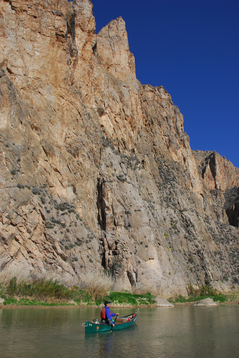
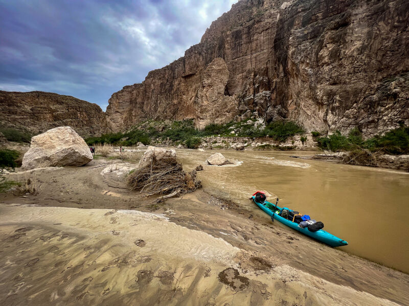
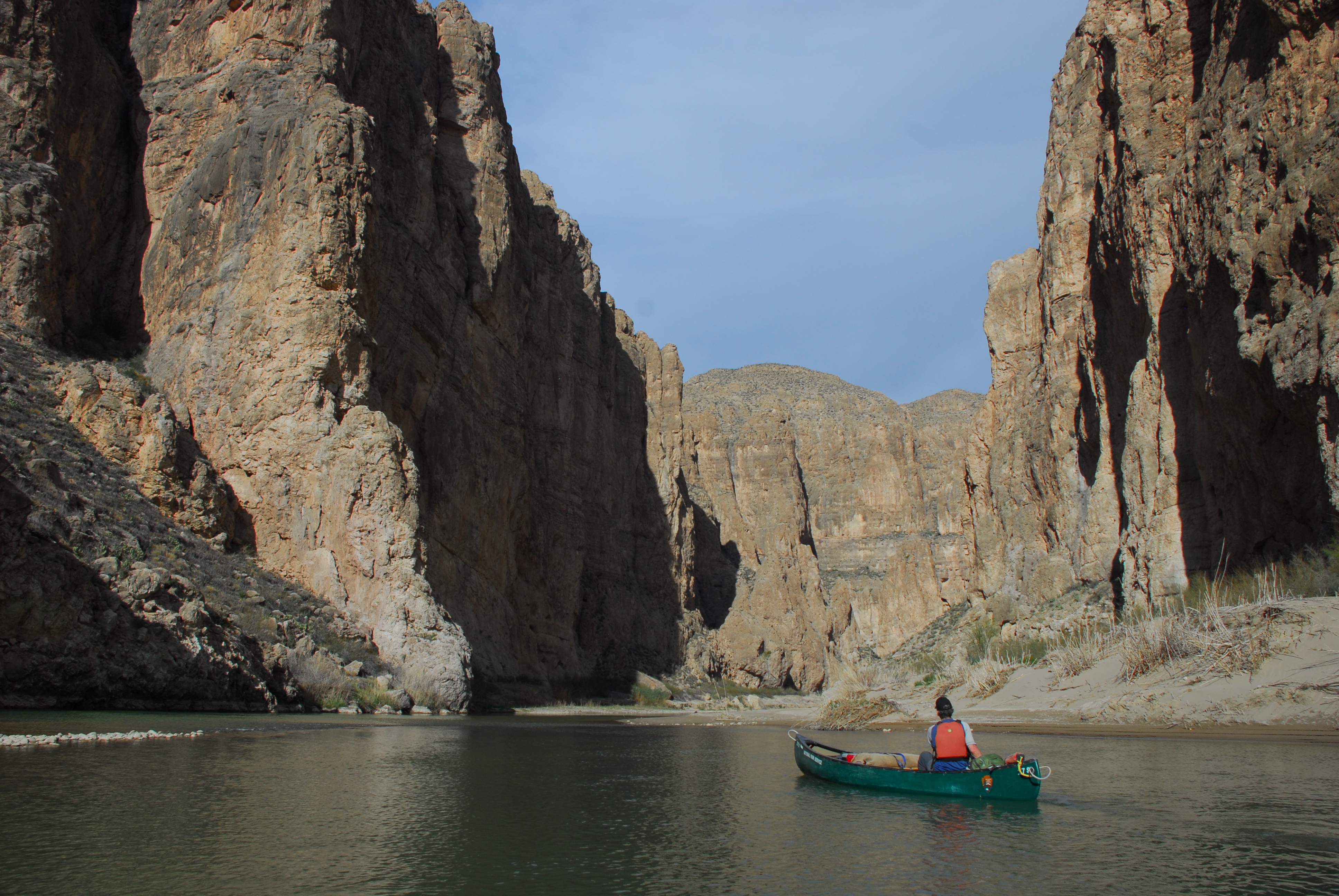
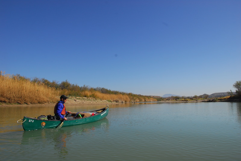
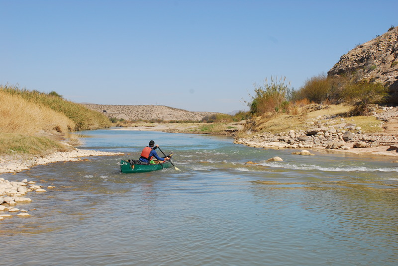
This stretch of the Rio Grande does not have much in the way of whitewater, but Boquillas Canyon is one of the most scenic river trips in the country. It can be done as a 3-day trip, but a longer, 5-day trip affords more time for hiking and exploration. The normal put-in is at Rio Grande Village, although some choose to combine Boquillas Canyon with upstream reaches, such as Mariscal Canyon and Hot Springs Canyon. 150 cfs or higher is recommended for rafts and kayaks, but the river is known to be navigable at flows below 100 cfs on the Rio Grande Village gauge.

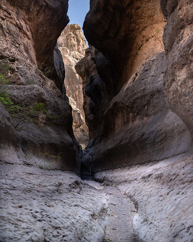
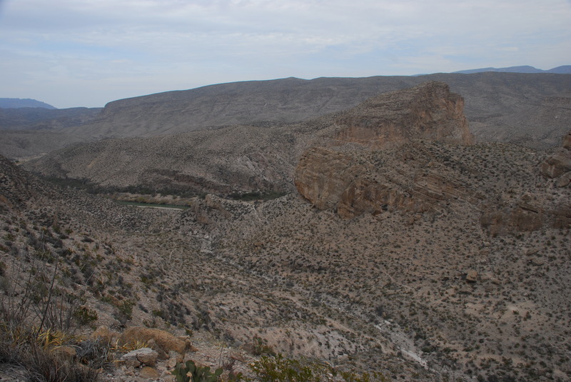
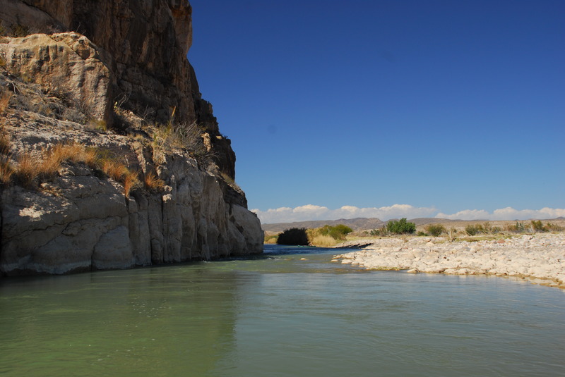
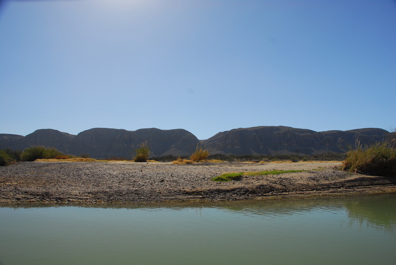
Camping is not permitted along the 5.4 river miles between Rio Grande Village and the Boquillas Canyon entrance.  For this reason, as well as strong winds that sometimes blow across the open terrain upstream of the canyon, an early start is recommended on Day 1.  Once inside Boquillas Canyon, there are plenty of options for camping, including gravel bars and floodplain terraces.  The river exits the national park and enters private land a few miles below the mouth of the canyon, but when the river is relatively low, there are several islands in the stream that provide legal camping options along the last 8 river miles above the takeout.  The canyon itself stretches for 17 river miles, providing stunning scenery and numerous opportunities to explore side canyons. The Marufo Vega Trail offers additional options for extended hiking through the desert landscape (Marufo Vega is a loop trail, so it is accessible from both the river and the park road.)

Logistics:

  • Prior to putting in, you must obtain the appropriate permits for river and backcountry access from the park headquarters at Panther Junction.
  • The normal put-in is at the river access point in Rio Grande Village, located near the group campsites.
  • The preferred takeout these days is at Heath Canyon Ranch at La Linda. Access is available on the downstream river left side of the abandoned Gerstacker Bri
...

River Features

Rio Grande Village River Access

Distance: 0 mi
Rio Grande Village River Access

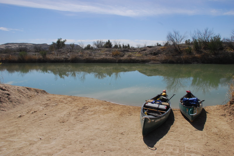
Access on river left in Rio Grande Village.

Boquillas Port of Entry

Distance: 2.13 mi
Other
Boquillas Port of Entry

This legal border crossing allows Big Bend National Park visitors to take a rowboat across the Rio Grande and visit the Mexican border village of Boquillas del Carmen. The crossing was closed after 9/11 but reopened in April of 2013. It is popularized in the Robert Earl Keen song 'Gringo Honeymoon.' No paddler access.

Boquillas del Carmen

Distance: 2.77 mi
Other
Boquillas del Carmen

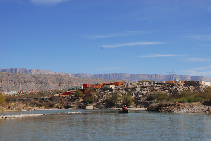
This quaint Mexican border village at river right subsists primarily on tourist income from Big Bend National Park visitors. It became practically a ghost town after 2002, when the Boquillas Port of Entry was closed due to post-9/11 security concerns. Since the reopening of the port of entry in 2013, the village has rebounded.

Boquillas Canyon Overlook

Distance: 4.97 mi
Other
Boquillas Canyon Overlook

A parking area at river left gives Big Bend National Park visitors a scenic view of the entrance to Boquillas Canyon. A short (1.5-mile round trip) trail leads from the parking area to the canyon entrance. No paddler access.

Boquillas Canyon Entrance

Distance: 5.26 mi
Other
Boquillas Canyon Entrance

End of Boquillas Canyon Trail

Distance: 5.53 mi
Other
End of Boquillas Canyon Trail

Marufo Vega Trail

Distance: 12.63 mi
Other
Marufo Vega Trail

The Marufo Vega Trail crosses the draw at river left. Marufo Vega is a 14-mile round-trip strenuous-- and often poorly-marked-- loop trail that leads back to the Boquillas Canyon Overlook. The trail provides a convenient way for paddlers to explore the desert. However, it is always recommended that you bring a GPS when hiking in the desert, as trails can become faint due to underuse, or they can become confused with game trails, arroyos, and other natural features. Always bring plenty of water and salty snacks when hiking in the desert as well. Dehydration and hyponatrumia are the leading causes of avoidable fatalities in Big Bend.

Mouth of Boquillas Canyon

Distance: 22.44 mi
Other
Mouth of Boquillas Canyon

Heath Creek Confluence

Distance: 22.64 mi
Other
Heath Creek Confluence

Large, normally dry arroyo at river left

Exit Big Bend National Park

Distance: 26.51 mi
Other
Exit Big Bend National Park

The land at river left is private from here to the takeout.

Stillwell Crossing

Distance: 28.93 mi
Other
Stillwell Crossing

The Stillwell family, who owned a ranch on the Mexican side of the river, formerly kept a barge here and used it to access their ranch.

Gerstacker Bridge

Distance: 34.53 mi
Other
Gerstacker Bridge

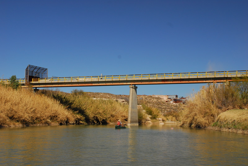
Abandoned international crossing, built in the early 1960s by Dow Chemical in conjunction with the (also now abandoned) fluorspar plant at river right (fluorspar, AKA 'fluorite', is the mineral form of calcium fluoride). The bridge was named for Carl Gerstacker, the CEO of Dow Chemical at the time. Fluorspar was mined in the mountains on the Mexican side, processed at the plant, and shipped via truck to the railroad in Marathon.

Heath Canyon Ranch Access at La Linda

Distance: 34.57 mi
Take Out
Heath Canyon Ranch Access at La Linda

The Heath Canyon Access at La Linda is on river left downstream of the bridge. Privately owned and managed for many years, the access is now owned and operated by Texas Parks and Wildlife. For river access, users are now required to obtain a Limited Use Permit (LPU). This annual permit ($12/person 17 & older) is available for purchase online. Then users will need to stop by and self-register at the Black Gap Wildlife Area HQ on the way to the river access (55 miles south of Marathon, 18 mi down FM 2627).


Ran March 10-12 (3 days 2 nights) in 2024. Even as a former Rio guide, I would probably disagree with the other report saying that 35-40 cfs is 'plenty' for this trip but a sufficiently determined boater shouldn't have any issue navigating this even down below those levels if you are comfortable with walking a few times. In our trip of 5 tandem canoes, there was only one other person besides myself with whitewater experience and while I think class II would be a generous rating for this stretch, there are definitely potential hazards on this run. Before we even got into the canyon, one of the boats on the trip drifted into a root-ball and capsized. Water wasn't flowing fast enough for this to present any serious danger to the people in the boat, but we spent a long time recovering gear from the river and it put us behind schedule. To be honest, the 'wildlife' (horses, donkeys, mules, cattle) are the biggest danger on this stretch other than dehydration, and we often woke up to the sounds of donkey brays and hooves clopping outside of our tent. The animals are generally docile but definitely made it clear that we were not welcome in their space. This should probably go without saying but pack out what you pack in; I grabbed an entire bag of trash and empty beer cans off of a beach near the end of the canyon. Flows were low and we really had to paddle hard for much of this trip, I'd budget 4 days if you go at these flows. I will say that the water quality leaves something to be desired. Being a national park, there's not a noticeable amount of litter but it's very obvious that large grazing animals inhabit the banks and are not selective with their bathroom spots. We found cow patties floating in the river and a group who ran lower canyons told us they found a whole carcass.

With all that being said, Boquillas Canyon is one of the most incredible places I have ever seen with my own two eyes and while it's a cliche, the pictures really cannot do it justice. Some of the most gorgeous rock formations you'll ever see, refreshing water temps, and lots of interesting plants and animals to see. Cannot recommend this trip enough and would recommend that you go at higher flows but would say that the trip is absolutely still worth it even when low! If you aren't familiar with this landscape make sure you talk to someone who is. Even in early March it was pretty hot, and incredibly dry (wear sunscreen and bring chapstick on the river) - park's recommendation for water is a gallon/person/day but even at this time of year as a larger than average person I found that this was approaching not enough. At this flow, I can't say there's anything I would call a 'rapid' but there are definitely times where you'll need to navigate around rocks and other debris. This might be for the best, as I found myself never wanting to look at the water, as my eyes were always gripped by the canyon walls or the horses running along the banks.

As far as logistics go, the description on this page does a good job. We camped at Heath Canyon Ranch, and the folks running the ranch were quite kind and happy to accomodate us. We rented canoes from Angel Expeditions for a reasonable price, drove to the put-in, and they drove our cars back to the take-out and even put gas in them for us. As is the case with almost the entire park, cell service at Heath Canyon Ranch and while on the river is rather non-existent.

Get out on this river when you can! With climate change and water policy in the west, this stretch of the Rio is likely as endangered as its upstream counterparts in NM. I drove in from Ohio and it was absolutely worth the drive.

RC

36 cfs is plenty of water for this trip.  Permit and a few items of specific gear are required per National Park regulations.  Boquillas Canyon is relatively rapid free but there are a couple of bumpy but easy rapids at 36 cfs.

We made this a 4 day, 3 night trip.  Because Boquillas Canyon has a lot of skirt, there are endless places to set up camp.  Our camp 1 was about 11 miles from Rio Grande Village.

Day 2 we took lunch where the Marufo Vega trail meets the river.  We did a 3 hour round trip up and back down the Marufo Vega Trail.  After the hike we paddled to camp at Rabbit Ears Formation at El Guero Canyon.

Day 3 we spent exploring El Guero Canyon.   This is a must see/hike for this trip.  We spent night 3 at El Guero.

Day 4 we paddled to the take out at Heath Canyon Ranch.

I did this trip with my kids Barton Cunningham and Alec Manley 3/9/24 to 3/12/24

This trip was during 1,700 cfs at Rio Grande Village Guage

This is a beautiful trip of 3 days, 2 nights, 34 miles from Rio Grande Village through 17 miles of Boquillas Canyon to take out at Heath Canyon Ranch.

We paddled 10 miles on the first day which was 2 miles short of our goal due to a delay.

The next morning we were treated to over a dozen donkeys making their way along a trail on the opposite shore. That was a fun thing to see.

Day 2 we paddled 6 river miles that took us through Arroyo Venado Rapid (II-III) with a pushy whirlpool

I ran it paddling my 16' Dagger Delta loaded with approx 90 lbs of gear forward and had no issues.

Night 2 we camped at Canyon el Guero which is also at Rabbit Ears formation. That night we saw one of the most beautiful sunsets that I think I've ever seen, it kept going and going and going. We had plenty of time at this camp so we ate well, got rest and enjoyed where we were for all that it had to offer.

Day 3 was a fun, fast, exhilarating, 17 mile finishing paddle through 2 miles of canyon and 15 miles of desert to Heath Canyon Ranch take out.

I'm glad that I had several trips through Santa Elena Canyon before doing Boquillas. Boquillas is much less forgiving. Both are extremely beautiful in their own way.

River trip on the Boquillas Canyon section of the Rio Grande.