Rio Grande
3. Santa Elena Canyon: Lajitas to Santa Elena Canyon River Access (20 miles)

| Difficulty | II(III) |
| Length | 20.6 mi |
| Avg Gradient | 7 fpm |
| Gauge | Rio Grande Nr Castolon, Tx |
| Flow Rate as of 29 minutes | 1170 cfsII-III(IV)high runnable |
| Reach Info Last Updated | March 8, 2019 |
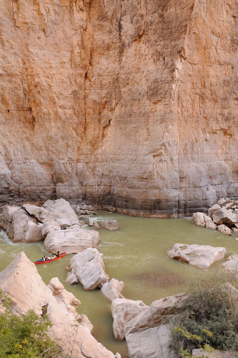
In whitewater terms, the Rio Grande is not particularly challenging, but paddling through Santa Elena Canyon should still be on every whitewater paddler's bucket list, simply because of the scenery. Santa Elena Canyon is a relatively narrow gorge (100-150 feet wide) with sheer cliff walls that tower as much as 1/4 mile above the river on both sides. Unlike most canyons, Santa Elena also has two mouths-- the upper end looks just like the lower end. This is one of the most remote and untamed stretches of river in Texas. At Entrance Camp, you are at one of the least accessible points in Big Bend National Park, a place experienced only by a few paddlers every year-- and by the horses that run wild along the banks of the river.
At low to moderate levels, there are several 'wall shot' rapids inside the canyon that are arguably more difficult than the named rapids (Matadero, etc.) above the canyon. Generally, all of these rapids-- in addition to the named Class II rapids-- will require some maneuvering by canoeists, particularly when the river is relatively low and channelized. However, whitewater paddlers will probably find them to be straightforward. This section gets pushy at high levels (thousands of cfs), but most of the rapids (with the exception of Rock Slide) wash out at those levels.
This stretch is doable as a day trip when the river is running high (> 1000 cfs.) It can be rafted down to 500 cfs as a 2-day trip and canoed or kayaked as a 2-day trip down to 150 cfs. The entire section of river is in Big Bend National Park and requires a permit obtainable at park headquarters or in Lajitas. The state and national parks require anyone on a river trip to wear their PFD's through named rapids. All of the river access points are on river left (Texas side.)
Distances and gradient measured using GIS tools in 2015.

Large dirt parking lot and boat launch at river left
Wall shot at the top at low levels (some canoes may want to line here.) Straightforward at medium to high levels.
Wall shot on the Texas side at low levels. Straightforward at medium to high levels.
At a large island in the river, take the left side. High-water channel at river right opens up at 3000 cfs.
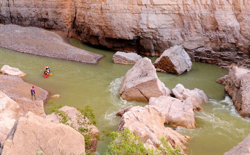
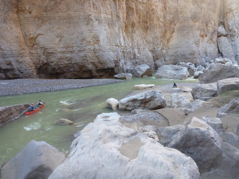
Rapid that begins adjacent to Entrance Camp and continues into the upper mouth of Santa Elena Canyon. At low to moderate flows, the water splits into multiple channels near the canyon mouth.
Popular camp for overnight trips, located at the upper mouth of Santa Elena Canyon. A pack trail provides access up onto the Mesa de Anguila, a spectacular and lightly-traveled area of Big Bend National Park (normally only accessible via a multi-day backpack trip.) It is also easy to access the rim of the canyon from here via a short 'primitive' hike. You can even hike along the rim as far down as Rock Slide Rapid, to get a bird's-eye view of it.
Rock Slide is definitely challenging for recreational canoes and can be challenging for beginner kayakers (particularly those paddling recreational kayaks), but it also tends to be over-hyped. At low to moderate levels, the flow is slow, and there are plenty of huge eddies to catch. Make no mistake-- the rapid has some dangers (particularly undercut rocks), and numerous paddlers have wrapped canoes or yard-saled sit-on-tops here, but it should be a relatively straightforward 'read and run' for most whitewater paddlers. Scout or portage from the large rock pile at river right.
Most of the instructions below apply only to low or moderate flows. At the top, you can either go far right around the rocks ('Mexican Gate') or left ('Texas Gate.') At moderate flows, another line opens up at the center. Eddy out below the gates. From here, there is usually only one line-- through a slot at the center of the river. From the Texas side, the current will try to push you into the boulder left of the slot, so either ferry across and approach the slot from the Mexican side, or peel out into the current so you can stay to the right of the flow.
Below the center slot, there is a large pool. The channel then splits again around another prominent boulder. Left of the boulder is 'Bottle Neck' (a tight squeeze at low to moderate flows) and right of the boulder (far river right) is 'Dog Nose' (a larger channel.) Below Bottle Neck/Dog Nose, start working left to go between a couple of pairs of exposed rocks, then the paddle out should be straightforward from there.
Undercut rocks and sieves are a risk in Rock Slide, particularly at low levels. In general, if you swim, swim through the channel that you would have taken with your boat.
At high flows (thousands of cfs), the rocks become submerged and form holes, and the 'gates' and 'slots' become tongues. At these high levels, there are some tricky hydraulics and eddy lines around some of the holes, and the holes may not be apparent from upstream because of the siltiness of the water. However, the lines around the holes are also straightforward, and the holes themselves are not particularly grabby.
Significant side canyon at river right (reference point)
Alcove formation on the Mexican side (reference point)
Some people choose to access the river here for 'boomerang trips' (paddling upstream to Fern Canyon at low water levels-- generally < 150 cfs), but accessing the river here requires hiking your boat about 250-300 yards through sand (and sometimes through Terlingua Creek, if it is running.)
Parking/access at river left. Composting toilets are available.
Main part of Rockslide Rapid