Weber
01. Aspen Acres to North New Lane
| Difficulty | I-II+(III) |
| Length | 10.8 mi |
| Avg Gradient | n/a |
| Permit | None |
| Gauge | Weber River Near Oakley, Ut |
| Flow Rate as of 1 hour | 108 cfsbelow recommended |
| Reach Info Last Updated | June 22, 2023 |
One of the more scenic rivers in northern Utah. The run rates Class II - III- with some wood avoidance and is +/- 9 miles in length.
Beautiful. Ideal for inflatables and light weight kayaks. Two mandatory portages.
Several runnable drops. Ideal level 600 cfs, runnable down to ~450 CFS and 1000+ CFS is rowdy.
River Access is an issue. There are threats to this river access from Private Landowners.
Although unsigned, there is a DNR river access through the Aspen Acres (Shoshone Rd) green gate.
Park in the large dirt pull out on the north side of the road and hike down to the river.
This launch is just above where Smith and Morehouse enters and increases the size of the Weber.
The New Lane Road takeout is just downstream from a dam that diverts 3/4 of the river into a canal.
Flow probability forecast: https://water.weather.gov/ahps2/probability_information.php?wfo=slc&gage=oawu1
IN 2017 USAC won a supreme court case on this section of river (Holiday Park to Echo Resevoir) The court ruling is here: https://wildlife.utah.gov/special-weber-river-rules.html
In basic terms we have a right to the water way and the ground on which it flows, up to the high water mark. Access to the river must be through public access points or private with permission from the land owner. Please obey trespassing signage.
There is a road you can walk down to a bridge, At the bridge there are some stairs that take you down to the river. From this put in to the Smith and Morehouse creek Confluence I have encountered Barb wire fences across the river. Be on the look out!
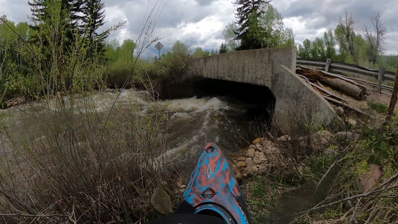
An alternate put in location. I have been putting in on the South side of the road and going under the road in the culvert. 40.785072, -111.155704
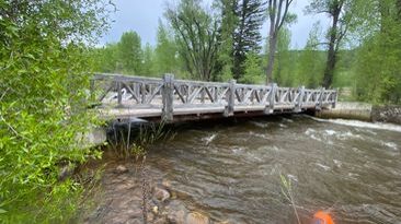
This is a low bridge, In a kayak ( with the correct skills) you can catch the eddy on the right (north) side and squeeze under at 1400cfs and lower. The eddy is small. In a raft or Ik, I would catch an eddy up higher and portage around it.
This is an alternate take out. There is a small dirt road going to the River. Teh upstream side is private property but the downstream side is Mountain Regional Water Service Dist. property.
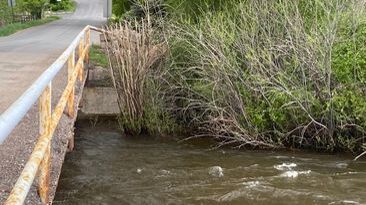
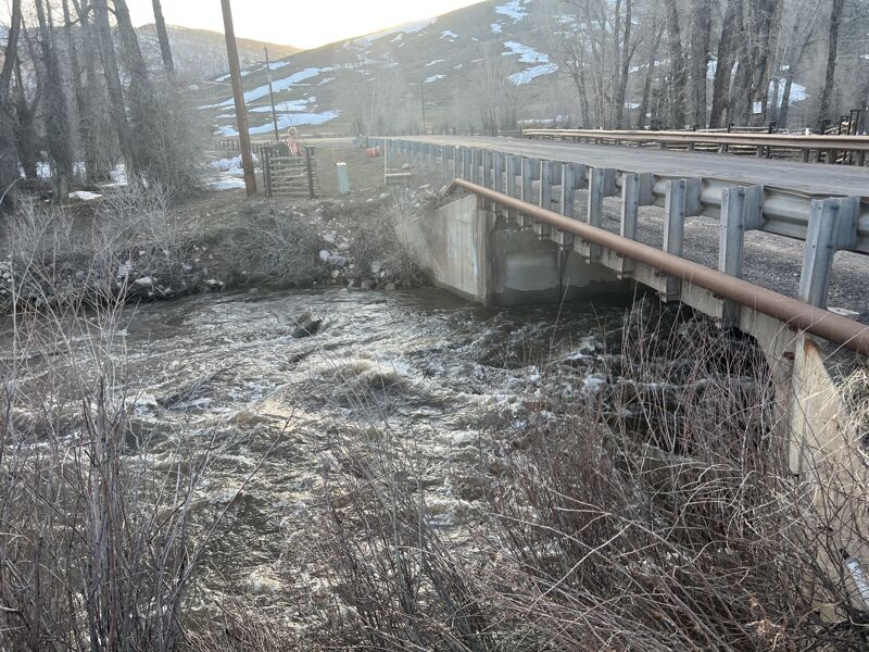
This is another Take out- portage at High water. I have taken out here and skipped the lower section of this run. Below here are a couple man made diversions. There is an Eddy undert the bridge on the right side (North) in the bushes, The left (south) side is moving fairly quick with not a lot of eddy service.
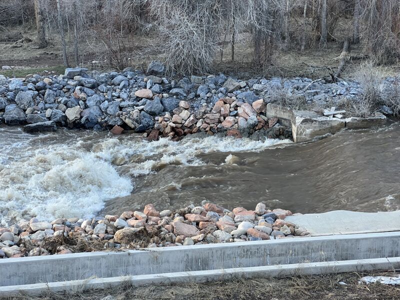
This is a man made slide, it changes with levels, I have never ran it. low water the concrete has metal sticking up. At high flows it looks retentive.
Jun 2, 2025
We went less than a mile from aspen acres put in and experience 3 very dangerous riverwide barbed wire fences. We had to abandon the trip after the last fence went pretty badly for one of our group. A Resident informed there were up to perhaps 10 fences now days. (May not be legal but they're doing it anyway. At least up to the confluence.) Could have been a really fun section of river but very dangerous starting that high up given the fences.
Jun 15, 2024
Ran this at 920 cfs on June 15th. In the past I have run this same stretch at 1000 cfs and 750 cfs. I have only run this in a packraft. I typically put in at smith and morehouse creek 40°47'05.6'N 111°09'20.2'W and take out at the 'alternate take out' 40°44'07.7'N 111°15'08.2'W. You can also put in where East Weber Canyon Road crosses over the river 40°46'21.8'N 111°11'47.7'W to run the bottom 2/3 of the river, which is more difficult than the top 1/3. In my opinion, more water is much better here. A lot of the features that create fun drops/waves/holes are boney below 850cfs. At lower flows, a lot of the rock bars become exposed and the river can constrict to a smaller channel giving you less room to navigate.
Personally, this is my favorite stretch of whitewater close to SLC, and it's unfortunate that it has such a short window of good flows each year. In the 850-1000cfs range, the run is fairly consistent class 2 whitewater with a few class 3 wave trains and holes towards the end of the run. There is no real flat water. The good eddies are few and far between, but you can find micro-eddies that could fit a single boat along the banks. The river slowly increases in difficulty from top to bottom, so you can opt to just lap the bottom 2/3 of the river if you want more meat. Most of the action in this river consists of waves and holes that can be avoided at higher flows but are more fun to punch through. The bottom half of the river has a lot of shallow rock dams on river right, all of which are super fun drops at flows over 850cfs. In my experience850-1000 cfs is the ideal level to float this river.
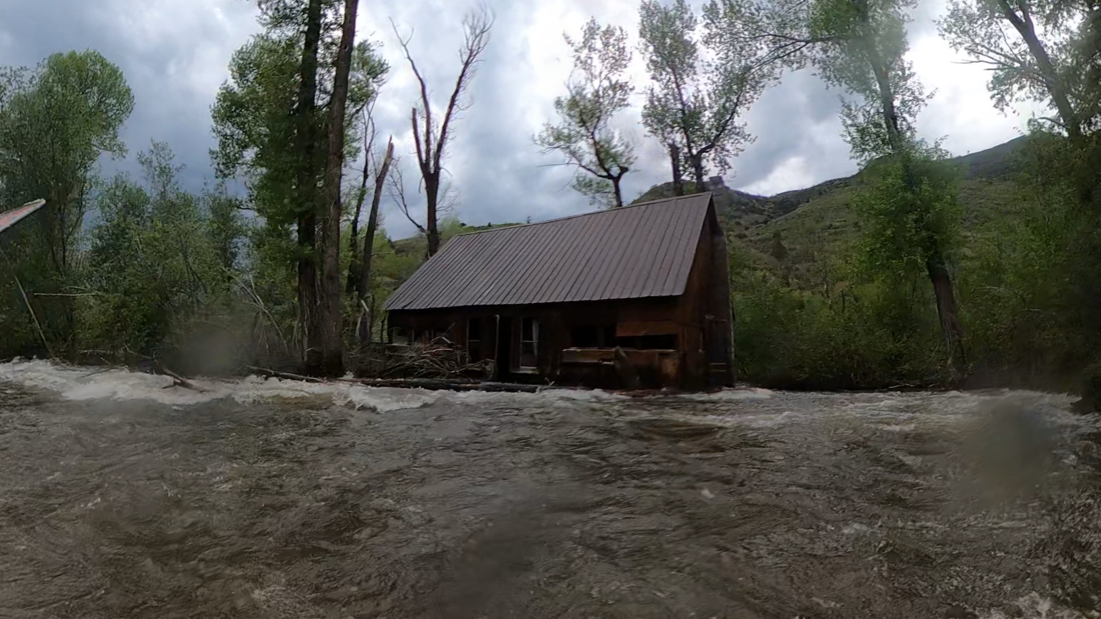
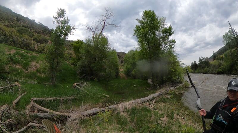
Towards the last mile of the river, there are some quick turns in the river with a fair amount of wood piled up on the outside banks. You'll obviously want to hug the inside corners of the river here, but you will have plenty of time to react and plenty of room between you and the wood at these flows, just keep your eyes downstream. In the last mile there is also an abandoned cabin on river right that is slowly being eaten by the river. As of this year, the outer wall of the cabin has been ripped off and deposited along the outside of the next few banks. This cabin will continue to deposit more wood as time goes by, so just be cautious towards the bottom.
Lastly and most importantly, there is a mandatory low bridge portage. The low bridge is right here 40°46'28.6'N 111°11'40.6'W. There is another bridge right before it, with a good eddie on river right, right here 40°46'32.4'N 111°11'36.2'W. You can take out, walk the paved road on the south side of the river, and put back in just after the low bridge in a little tributary creek on river right, here 40°46'28.8'N 111°11'41.2'W. This is all on private property so please be respectful and don't dilly dally, though I've never been given a hard time here. This can all be avoided if you put in where East Weber Canyon Road crosses over the river and just float the bottom 2/3 of the river, which is immediately after the low bridge (coordinates given above).
In summary, if you're confident in class 2/3 and want to paddle whitewater then I would highly recomend this stretch, but only over 750 cfs. I can't speak for what it would be like at lower flows, but I'm guessing it's more shallow and less fun.
May 17, 2021
Ran @450 cfs on 5/16/21. 2 playboats and 1 SUP. Bumpy with some fun class 2 wave trains. A handful of small 1-2 kayak eddies but otherwise very continuous class 2 boogie water. None of the man-made waves were in at this level. Took out at this picnic area (https://goo.gl/maps/2T6ijEUmRhusdPPA8) although this would be very difficult take out at higher water.
May 20, 2020
Was on this section on 5/19/20, portaged one low bridge- https://goo.gl/maps/hPeAaXSuNQbF6MWn7
and all of the diversion dams at higher (1000+) water level. Following previous comments, below or at Smith and Morehouse is mandatory for putting in, there are still 5 to 6 fences below Aspen Acres until right above the SM confluence. It is confusing and dangerous, because with all the 'do not trespass' signs everywhere Aspen Acres is the only clear river access point that is marked. Interested to see if anyone is working on this access issue?