Popple
C) Morgan Lake Rd to Hwy 101 (5.4 miles)
| Difficulty | II-III+ |
| Length | 5.1 mi |
| Avg Gradient | 20 fpm |
| Gauge | Popple River Near Fence, Wi |
| Flow Rate as of 54 minutes | 37 cfsbelow recommended |
| Reach Info Last Updated | April 17, 2019 |
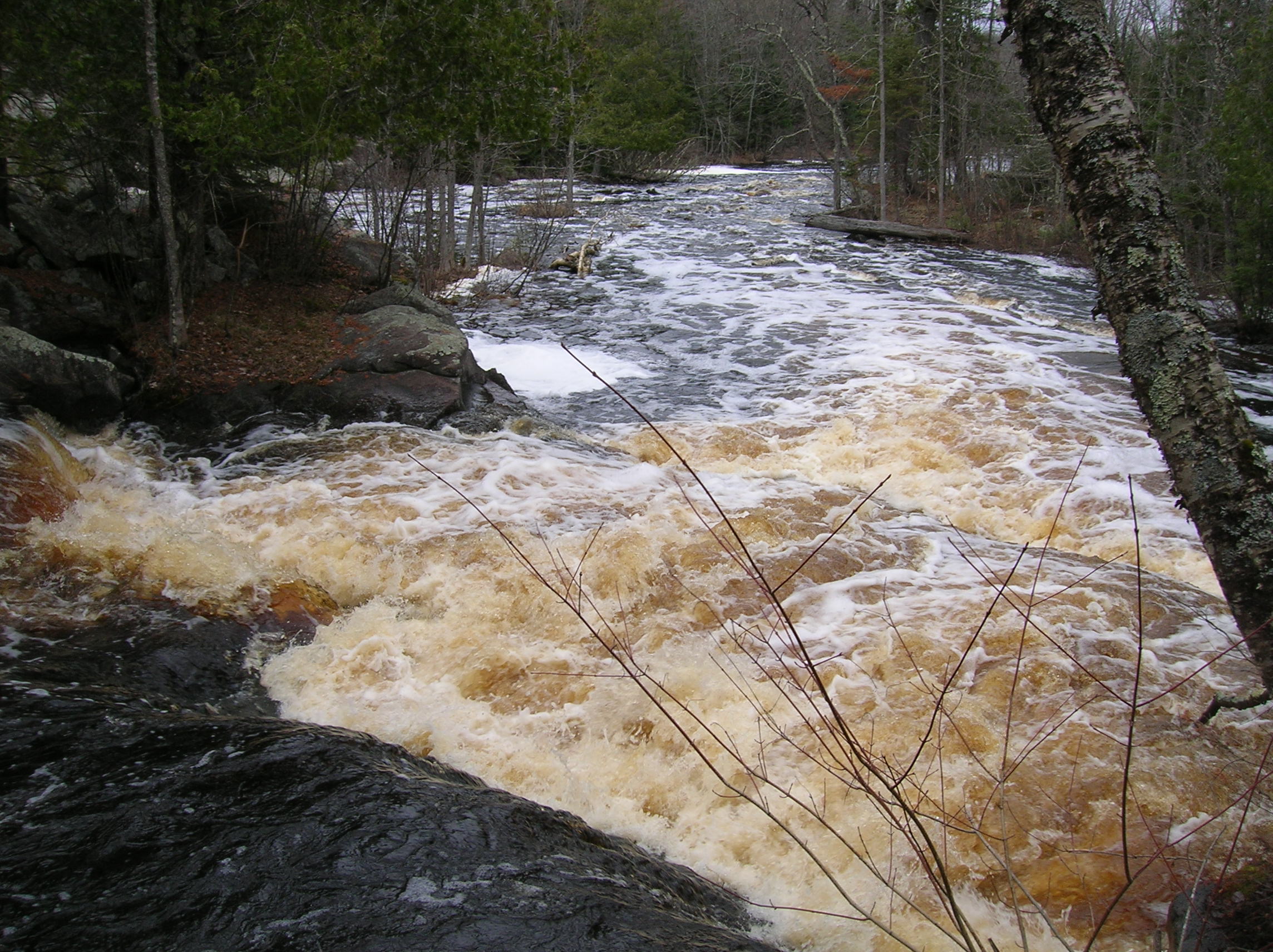
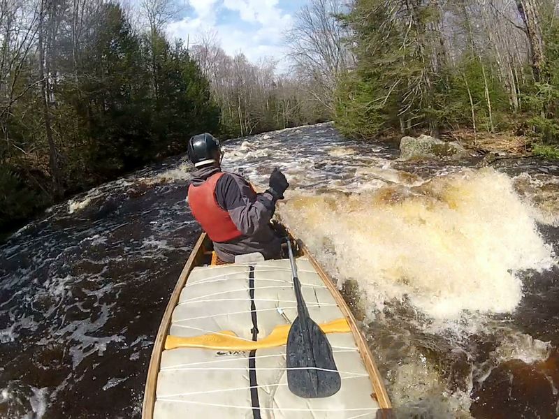
Easy access. Best whitewater section of Popple. 27% of length is 14 rocky rapids(II) with two falls (III) over ledges. Trip 1.5-2.5 hrs (avg 1.9)
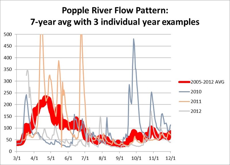
Little input (30cfs) to flow from groundwater (springs) is a limiting factor for this river. The best water levels are usually not from snowmelt, but from early spring rains that come when the ground is still frozen until trees fully leaf-out (April-May). A rain of 1” at this time will provide excellent water levels, while from summer through fall it may take a 3” rain.
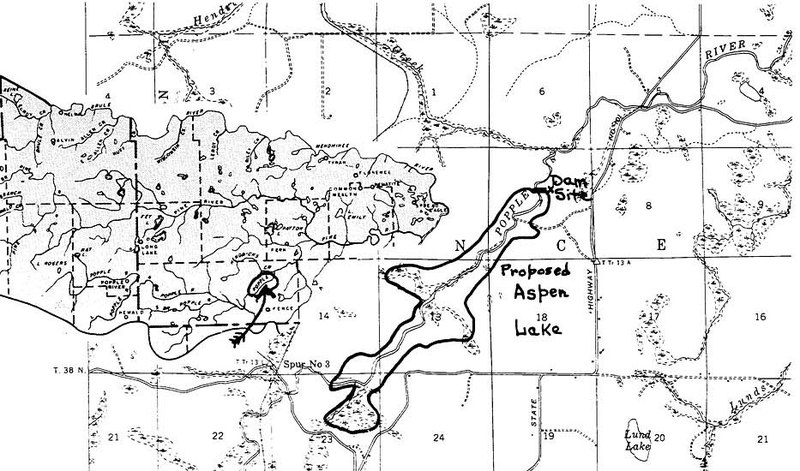
In 1965 the Popple River became a *State of Wisconsin designated) “Wild River.” This state designation pre-dated and was the model for the national Wild and Scenic River program. The issue that rallied public support for the creation of a protected, Wild Rivers designation was the 1961 proposal to build a dam across Big Bull Falls that would have impounded waters (to be named Aspen Lake) for nearly the entire length of this section of the river (all the way back to Little Bull Falls) and turn this spectacular stretch of river into a lake for private development (see image 888955 under photos tab). The dam was not permitted, Wild Rivers legislation passed, and today over 90% of the land along this stretch of the Popple is owned and protected by the WI DNR.
Geologically the bedrock outcrops at each falls along this stretch is metamorphosed basalt and intruded volcanic granite that originally solidified off the ocean floor south of the equator nearly 2 billion years ago. It is some of the oldest rock in North America. The unique values of ancient bedrock and wildness add value to your run down this action-packed stretch of river.
Drops include Little Bull Falls (II+) and Big Bull Falls (III). Both have marked portage trails that facilitate scouting. Big Bull Falls can also be viewed from the signed hiking trail off of West River Rd (from Hwy 101). Neither of these are 'falls' in the traditional, vertical sense.
Little Bull is a
...
This rapids can be added to the run if you drag your boat a short ways above the bridge along the river-right. The bridge and bedrock ledge concentrate flow through this short drop. At high flow (>650 CFS) the center path leads to a large sucking hole directly under the bridge. At lesser flows the hole is a sweet s-shaped path past the brink of the hole. At low flow, the rapids ends in a confusing river-wide stone-field. Be prepared to stop or back-ferry immediately after s-shape drop.
A good warmup rapids with a boulder field at the end. It ends in a large relatively still-water pool providing easy access to the start portage (or scouting trail) on river left, immediately after the private cabin. The portage is on private land. Use is thankfully permitted, so please respect the land-owner’s property. A 1/3-mile emergency-only hike-out exit from Little Bull Falls is along a gated, private access road to the cabin on river-right, across river from the portage takeout landing.
The portage is signed and is 385 feet. The start of the portage (or scouting trail) is on river left, immediately after the private cabin. The portage is on private land. Use is thankfully permitted, so please respect the land-owner’s property. A 1/3-mile emergency-only hike-out exit from Little Bull Falls is along a gated, private access road to the cabin on river-right, across the river from the portage takeout landing.
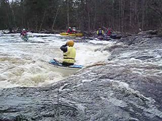
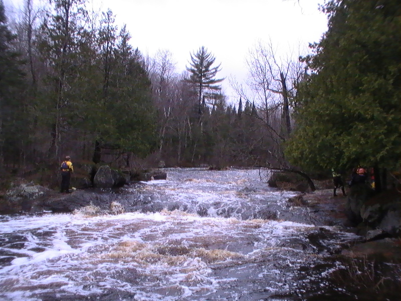
Scout this drop before running! The last 70 feet is a boulder-lined channel leftover from the logging era that diverts most of the flow down the falls side of the island. This mini-gorge results in little to no option once committed. The falls is a short, somewhat horse-shoe shaped ledge. It can form a quite aggressive hole at moderate-to-high flows and should be run by groups of experienced whitewater boaters with spotters and throw ropes ready.
This gets REAL retentive! It is NOT recommended as a playspot because of a submerged, cross-river, flow-stopping bedrock wall, 10-feet downriver from the drop (Photos Tab: Little Bull Falls @30 CFS #888780). This hidden feature pushes almost the entire outflow from the hole from left to right. Just above the drop, deflected current is running right to left. This combo of opposing tail-push and bow-push tends to spin boats broadside in the hole. Exit the hole with the current to river-right. Contrary to the prior desription on this page, it is not possible to touch bottom and stand up in the hole (I have tried at low water). Rescue rope extraction from the hole (by experienced paddlers) has occasionally proved to be difficult, nearly fatal!
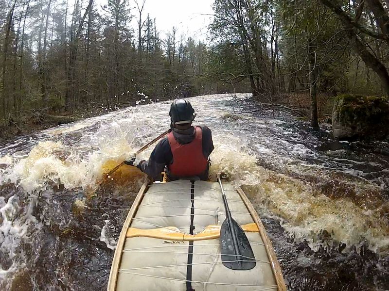
From the small pool right after Little Bull Falls, action soon gets very tight with good flow. Take a good look downriver for the occasional river-wide strainer before starting. At the end of the wider right-then-left turns, the rest of the river comes in from the backside of the island, giving the next part more volume. The exit from the river-wide boulder fan at the end is on the far left. Rapids are named in recognition of Paul Klopsteg's successful efforts to prevent Apsen Dam and thus save this section of river from being flooded (see article under news tab)
Class I-II, the last in group of initial rapids above and below Little Bull Falls.
There is a submerged rock in the main path through the right bootleg turn at the end of the main run in Big Murphy. At flow rates below 300 this usually undetectable rock can stop, or broadside and flip a canoe. At such flow rates, staying tight to the right through the bootleg is desirable.
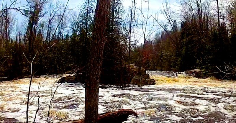
At 1/3 mile in length this is the longest rapids on this stretch. Many guide maps have the wrong location of this rapids. It is not where the DNR “nine-day” campsite is. Historically (from logging era), the original name for this rapids was changed from Long Rapids to Nine-Day Rapids when it took Anunson's crew 9 days to clear a log jam at the foot of this complex set of rapids. At flows under 300 CFS, to avoid hanging up on the rocky shallows, stay to the outside (river-right) as the river widens and turns abruptly left.
The name refers to the large pool just after the big boulder on the right shore. The angular rock (looks like a turtle to some) in the pool at the end of this rapids marks the start of the run towards Big Bull Falls.
This short, simple rapids, followed by a brief stretch of gently flowing flatwater is a disarming leadup to the urgency ahead. In early spring runs, from here to Big Bull Falls may be lined with high ice shelves that constrict or block passage (even if the upriver runs were clear of ice). Get a good view downriver before swift water begins again. If ice shelving looks too dangerous takeout, engage reverse and look for a usable spot to get out on river-right. The drag through the woods around the falls is adventuresome but doable.
The portage landing is on the right in a big, quiet pool after the large cedar tree behind the prominent shore rock. Sounds like an easy exit but unless you anticipate pushing up into the eddy after getting past the projecting rocks and initial wave action, the swift current will speed you beyond it. If this happens, it may be possible to power land on a river-right point of land before the falls. Landing on river left before the falls is an option for hiking off-river along the trail to West River Rd.
If you do grab the eddy and portage or scout the falls you will find the portage trail starts on an island so you will be crossing a little side-chute/creek of water. The eventual end of this 465-foot portage is not clear and thus varies with choice and conditions.
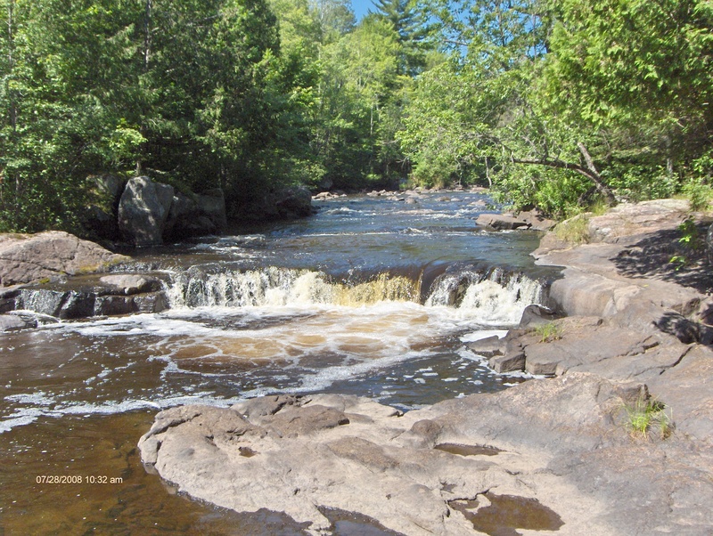
An island splits the flow. The right trips across a fun double-ledge of drops that is the usual choice at low to moderate flows. At flows below 5-600 the left is a narrow, generally congested (rocky) channel that is not runnable. At flows about 700 the left channel becomes runnable At very high flows (1350 cfs), the left side becomes the runnable route and the right is not because the current and wave train on the right goes straight into the woods below the drop. At such high levels, take out well above the drop to scout, because the ferry from river right to river left becomes difficult at high water. Scouting of the left channel can also be done from the hike-in trail off of West River Rd before starting the entire run.
A tight start runs through 2 sets of high action before widening out at the big right turn. The rest is swifts and class I flow all the way to the take out.
Pass under the bridge (read the staff gauge on the downstream left abutment). Takeout can be left, on shallow land before the little rapids or left, on the shallow gravel shore just after the rapids. Continuing on through the next section will add another 3-5 hours to the in-river part of your trip.
May 11, 2018
5/11/2018 374cfs Good Run. Plenty of fluid to clear rocks but some morphology (not all pushy and big waves). Ice is gone and pathways were clear of trees or logs
Mar 3, 2018
Had Aspen Dam been built just above Hendrick’s Creek. Nine Day Rapids, Murphy Rapids, and the river all the way to Little Bull Falls would have been obliterated. The 35 foot high structure would have blotted out over half the vertical drop from bridge to bridge.
Feb 11, 2018
Little input (30cfs) to flow from groundwater (springs) is a limiting factor for this river. The best water levels are usually not from snowmelt. They are from early spring rains that come when the ground is still frozen until trees fully leaf-out (April-May). A rain of 1” at this time will provide excellent water levels while from summer through fall it may take a 3” rain.