Stony River
1. Vepco Dam to Route 50(Upper Stony River)
| Difficulty | III+ |
| Length | 8 mi |
| Avg Gradient | n/a |
| Gauge | North Branch Potomac River at Kitzmiller, Md |
| Flow Rate as of 1 hour | 2.00 ftbelow recommended |
| Reach Info Last Updated | November 19, 2009 |
The river starts out very gently meandering down the narrow, technical, rocky gorge.
Warm water releases from the Power Plant make for some great winter boating! We ran this river after two months of solid sub freezing temperatures in WV, and the water is about 45 degrees because it was used as a coolant for the power plant just upstream. We did not see a spec of ice on the river all day. Before we put on, we looked at the nearest river (Abrams Creek) and it was frozen.
OTHER NEARBY RIVERS:
Nov 19, 2009
THE VOYAGEUR
On June 6th, Ned Howenstine (K),
Joe Sullivan (K), David Kogut
(OC1), Pete Dragon (K), and my-
self (K) met at the Myersville
McDonald's to dither about what to
run that day. While there had been
plenty of water earlier in the week,
our options were reduced by this
Saturday to only a handful of class
3/4 rivers. We decided to check
out the Upper Stony River in WV
which flows out of the Mt. Storm
reservoir and power plant operated
by VEPCO. I figured the level
would be in the 300 - 400 cfs range
which would have made for a good
run. It turns out that the Stony was
around 330 cfs that day.
After setting up shuttle vehicles at
the Rt. 50 bridge takeout, we
headed up to the put-in. Earlier in
the week, I had seen a warning
posted on AW's site about VEPCO
calling police to chase down a
group of boaters running Upper
Stony. They eluded the police. I
had assumed that perhaps they had
trespassed on the dam itself, not
having had any access problems on
that river several years ago. Well, I
soon found out differently. When
we arrived at the put-in, there were
blue No Trespassing signs every-
where. It would be very hard to
convince anyone that you hadn't
seen them if they caught you run-
ning the river. Being the wimps
that we were, we hightailed it out
of there and proceeded to set up
shuttle to run the lower Stony into
the North Branch of the Potomac.
By this time it was already noon, so
we had to hurry to pull this off.
Earlier in the week, Rick Koller
had told me about finding a takeout
on river left in the Potomac State
Forest in MD. I didn't have any
other details except thinking that he
had told me he could see the mouth
of the Stony from the take-out.
Well, we spent an hour driving
there and trying to find a take-out
from which we could see the mouth
of the Stony. Turns out there is no
such place. We first drove to a
spot where one of the park roads
loops down to the North Branch
but at a point about 1 to 2 miles
above the Stony (where there was a
bit of a climb up from the river to
the road). Getting desperate, we
back tracked up the mountain sev-
eral miles and drove down one
more park road along Laurel Run
to where it dead ends. After ford-
ing Laurel Run, Ned found a trail
that goes about 200 yards down to
the North Branch right where there
is the remains of an old cement
bridge consisting of two bridge pil-
ings and one span between them on
river left. Turns out that this is a
bridge that used to cross the river at
a town labeled Schell on page 27 of
DeLorme's WV mapbook. This
takeout is below Rattlesnake and
the two big ledges below Rattle-
snake or maybe two miles below
the mouth of the Stony.
We finally got back to the rest of
the group waiting at the put-in
about an hour and a half after we
left or about 1:30. We had a great
run down the lower Stony and the
North Branch. Our only difficulty
involved a couple of strainers we
had to contend with on the Stony.
The following is the warning Ned
wrote about the strainers that I
posted on the AW page for the
lower Stony River:
“On June 6, 2009, with the Stony
gauge at about 330 cfs, our group
encountered a very dangerous
strainer situation in a rapid ap-
proximately five miles into the run.
This is a mile or so after an earlier
river wide log/strainer that we port-
aged on river left. The extreme
danger of the five mile strainer ex-
ists because there are two separate
strainers in the same rapid and the
second strainer cannot be seen
from above the rapid. The first
strainer in this rapid is a large tree
visible from upstream that ob-
structs most of the river, blocking
about 3/4 of the river starting on
the river-right bank. The second
strainer is downstream of the first
strainer in a channel on river left.
This river-left channel flows
around the left end of the first
strainer but is extremely dangerous
because most of the current follows
along the river-left bank into a 1-2
foot drop where the second strainer
is located. This second strainer is
difficult to spot and can only be
seen by getting out of your boat
above the rapid and scouting from
the river-left shore. What also
makes this situation dangerous is
that the river-left channel appears
to be a potential way to avoid both
strainers by following the small
part of the current that does not
flow down the river-left shore but
instead flows sharply to the right
just above a boulder that guards the
right side of the drop with the sec-
ond strainer. However, this part of
the channel is narrow with swift
current. It is also shallow and has
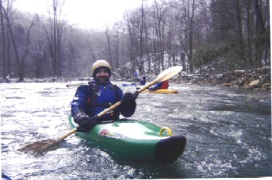
Lower Stony River, 6 June 2009
by Keith Merkel
PAGE 5 July 2009
THE VOYAGEUR
several exposed and partially exposed rocks, making
it impossible to take effective paddle strokes. On our
trip, four strong paddlers attempted this route and all
had major problems. All hung-up on rocks and two
were almost pulled into the second strainer back-
wards. After our run we talked to another group who
had run this section ahead of us (see the June 8 post).
One member of their group got caught in the upper
river-right strainer and was held under water for some
time. (Although he survived, I did not hear how he
got off the strainer). That group told us they had tried
unsuccessfully to remove the upper strainer. They did
attach a silver foil streamer to a small tree on river
right about 6' above the ground near the first upstream
strainer. This streamer is visible from upstream and
the first strainer itself is visible from well upstream.
There is an easy carry around both strainers on river
left.”
When we got to the North Branch, it was booming. It
was just under 5 feet when we got there and much
bigger than some of us had wanted. This was why
we had spent so much time trying to find a take-out at
the Stony's mouth, so we could avoid such big water.
This was much bigger than David had signed up for in
his open boat. It was also much bigger than I had
dressed for thinking I was doing an easier run down
the Upper Stony. But, I have to give credit to David
and the group: we made it down in fine shape except
for one kayaker swim between Rattlesnake and the
next big ledge.
Rick now claims that he never saw the mouth of the
Stony and the access he found was the same Laurel
Run access that we wound up using. It turns out that
other boaters know of this takeout as well, as is indi-cated by the following shuttle description in AW's
Comments for the lower Stony that I have revised:
“SHUTTLE: One aspect of this run is that if you don't
know where to take out, you must run 10 miles of the
Kitzmiller section of the North Branch to reach your
shuttle car. However, there is an obscure takeout for
the Stony about two miles below its confluence, pro-
vided you know how to get there. This access is on
river left at Laurel Run, across the river from the
'town' of Schell:
- From the Rt 50 bridge over the Stony, head west to
Gormania and turn right onto 560.
- Turn right onto White Church - Steyer Road (sign
for Laurel Run/Wallman recreation area).
- Veer left onto Audley Riley Road. Road turns to
gravel and you enter the state forest.
- Veer left at split and follow gravel road to dead end
turnaround next to Laurel Run. You are about 2/10ths
of a mile from the North Branch Potomac. To get to
the river, ford the creek at the fiber optic cable right
of way and walk down to the river. There you'll see
old bridge abutments and the cable right of way posts
as indicators of the takeout, which is shown as Schell
on page 27 of DeLorme's WV mapbook. *NOTE*: It
is advisable to walk down to the river and take serious
note of where the trail to the takeout is — this is NOT
a good area to get hopelessly lost in.”
All in all, it was another great run. We didn't finish
until 7 PM. We gathered at the Mountaineer Cafe just
south of Keyser, had a great dinner, and socialized
there until they closed at 10 PM. For those of us that
then drove home, it was a late arrival, well after mid-
night.
Jun 5, 2009
They will never catch us, Ha ha ha.
Mar 21, 2007
Great run on them cold winter days. The 50 degree water is wonderful when you have an air temp below 20. The run is fairly easy with a few rapids with pinning potential. The only other concern would be wood. Everything is boat scoutable. A must do if your looking to get into creeking.
Mar 21, 2007
Great run on them cold winter days. The 50 degree water is wonderful when you have an air temp below 20. The run is fairly easy with a few rapids with pinning potential. The only other concern would be wood. Everything is boat scoutable. A must do if your looking to get into creeking.