Stonelick Creek
1. St. Rt. 131 to St. Rt. 132
| Difficulty | III-IV |
| Length | 4.9 mi |
| Avg Gradient | 31 fpm |
| Gauge | East Fork Little Miami River at Perintown Oh |
| Flow Rate as of 56 minutes | 92 cfsbelow recommended |
| Reach Info Last Updated | January 30, 2012 |
Quite easy. From put in on St. Rt. 131 travel west one mile to St. Rt. 132. Turn left (South). Drive about 2.5 miles to bridge over creek.
From the South: Take I275 East to the Rt 50 exit. Turn left(North-west) on 50. Rt. 131 enters from the right. Turn right onto Rt. 131 and continue several miles to the bridge over the river.
From the North: Take I275 East to the Rt. 28 exit. Turn left(North-East) onto Rt 28. Continue on Rt. 28 to Buckwheat road. Turn right onto Buckwheat and take it to Rt. 131. Turn left and continue several miles to the bridge over the river.
The first known run of this small but very fun stream was back in 1967. However it wasn't until the mid 80's that the general whitewater population of the Cincinnati area became aware of it.
The usual put in is under the bridge where State route 131 crosses the river. Please note that this is private land. While there have never been any problems in the past, please be aware that inconsiderate behavior by boaters could result in the loss of this access.
I have also put in right below the dam on Stonelick lake, however access to the river there is poor. This adds about 4 miles of swiftly flowing water to the trip, but not much else.
The first mile or so of the trip is mostly swift current through a winding riverbed with a few nice play waves or gravel bars, depending on levels. Strainers and water flowing through trees and willows are likely, so keep an eye out.
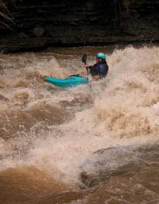
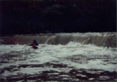
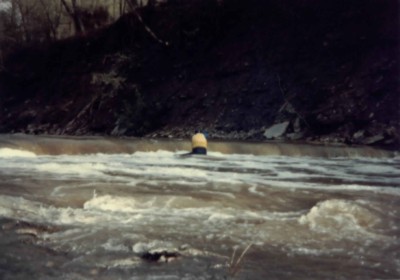
As one approaches the Belfast-Owensville Road bridge, which is at about the 2 mile mark, things begin to pick up. The road can be seen on the steep banks river right, winding down to the river. There are some nearly river wide ledges in this section that can be quite playful at most levels, but can be terminal at very high water. Usually though, some places are quite fun and others quite sticky, so check them out before jumping in.
...Oct 31, 2006
The last rapid has evolved now into something special. The hole at the bottom now will hold boats and boaters for extended periods of time, even at medium-low flows. Get RIGHT!
Oct 23, 2006
Ran this run a few days ago after all the rain. Put on with Matt Bodecker at what we thought was a moderate level. The gauge said 4.5 feet at the bridge. Once we started it felt like 7.5 to 8.5 with river wide (HUGE) holes and screaming speed! Just a warning to anyone who wants a less exciting run! Wood free at the moment.
Sep 18, 2006
Ran on JAN-5-07 at around 3' and last rapid was mainly a series of HUGE waves with the exception of a minor breaking wave/hole midway down,BIG FUN. Ran again following day at around 1.7 or so and the last rapid was a much more technical series of continuis ledges and holes. A buddy of mine new to the sport flipped in this rapid(was in a recreational old town rush!!!) he swam a good deal of it and flushed through all the holes.