Root
B) Horlick Dam to Quarry Park (0.2 - 0.6 mile)

| Difficulty | II(III) |
| Length | 0.58 mi |
| Avg Gradient | 20 fpm |
| Gauge | Root River at Racine, Wi |
| Flow Rate as of 41 minutes | 9 cfsbelow recommended |
| Reach Info Last Updated | October 25, 2025 |
Quick Facts:
Location: northwest edge of city of Racine.
Put-in: 42.7520, -87.8235 (Root River Dam, Old Mill Road, Racine, WI)
Take-out: 42.7462, -87.8218 (3340 Northwestern Court, Racine, WI) (Quarry Lake Park, Racine)
Shuttle: 0.2-0.6 miles (For short-run: just carry-up in Quarry Park. For full run; either carry, or car shuttle to parking at dam.)
Video Link: https://youtu.be/U53g71_0PtQ?t=35
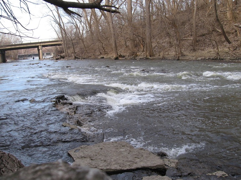
Character: Sloping bedrock (with virtually no instream rocks until the pool at the end of the run) creates fine playable features in fairly uniform-width channel.
River banks: Relatively steep limestone rock, tree-lined banks provide almost a 'up-north wilderness' feel in a county park within city limits.
Typical width: 70-120 ft.
Put-in is approximately 620' elevation.
Take-out is approximately 600' elevation.
Thus total elevation change is approximately 20'.
Drainage area: 190 square miles
10/85 Gradient Upstream of Put-in: 2.2 fpm (Low upstream gradient means rain in the upper watershed will take a day or two to bring this section to 'peak'.)
Percent Developed Upstream of Put-in: 30% (Low/Moderate development means runoff pattern will change seasonally; winter/spring will take much less to kick up flow, summer/fall will take considerably more rain to kick things up, since general lack of impermeable surface will soak up most light-to-moderate rainfall.)
10% Flow Exceeds: 419 cfs (I.E., on average, about 36 days per year should exceed this flow)
90% Flow Exceeds: 10 cfs
10/90 Flow Ratio: 41.9 (I.E., this is a fairly 'flashy' river (wide range of flows); summer storms can take flow from 10 cfs to over 3,000 cfs in two days, and (once past peak) flows can drop as much as 500-600 in 24 hours.)
Flow Info (using USGS flow data 2015-2025):
Average days per year above 200 cfs: 92
Average days per year
When Horlick Dam is removed, additional features (presently buried in the millpond) may be accessed from River Bend Nature Center, 3600 N.Green Bay Road. Signage indicates 'PUBLIC WELCOME ... TRAILS OPEN DAILY DAWN TO DUSK'.
Some maps show their driveway as Ivan Road (though I don't believe any signage carries that name). As you drive in, look for a sign for 'Visitor and Bus Parking', and park as near its entrance/exit as possible. From there, carry out and downslope, stepping around a gate, to River Trail. Follow that trail southwest until you come to the river. https://riverbendracine.org/wp-content/uploads/maps/Trail-map.pdf
NOTE#1: River Bend Drive (immediately across from the entrance to Batten International Airport) does not get you to the nature center!
NOTE#2: Looking at maps (or from shore in River Bend), you may see Charles A. Armstrong Park (on the west side of the river), and think access would be better from there, since that road brings you much closer to the river than parking at River Bend. However, Armstrong Park has a gated entrance, and is a private park (exclusively for S.C.Johnson employees and their famiies). Virtually all properties abutting the river-right bank upstream of the dam are privately owned until Johnson Park Drive (Johnson Park Golf Course, a City of Racine park).
A private property (house) sits on the north side of the dead-end stub of Buckley Road. To the south, a gravel pad easily accommodates 2 vehicles. (Possibly squeezing 3 in a pinch?)
Between that pad and the river, a 9+ acre parcel is listed as Racine County property, and seems like a possible access point. A wide trail through the woods heads toward the river.
HOWEVER ... there are multiple 'No Trespassing' signs prominently posted. I have tried contacting county personnel to understand why this is not open to the public, but have not connected with anyone able to reasonably answer that question.
Since River Bend Nature Center is open to the public (dawn to dusk) and has well-maintained trails to the river, it seems less crucial to get an answer about access here until the dam is removed and we check out how far upstream any meaningful features might be. (Whitewater boaters may be quite content to simply use the soon-to-be revamped access at Horlick Park.)
Horlick Park sits river-left just upstream of the Horlick Dam. The first parking lot (just inside the gate) is adjacent to a small park building with picnic tables and restrooms (likely locked until warm weather). The second parking lot is further north on the park road, and is the site of a launch/landing for non-motorized boats. (Electric trolling motors are allowed.) With the imminent plans to remove the dam, this launch/landing will be rebuilt and major relandscaping will be done once the new shoreline is established.
When that work is completed, this may be the 'put-in of choice' for whitewater boaters focusing on the shortest trip with the best whitewater. On the other hand ... if dam removal reveals any significant rapids/features further upstream, the above listed access points may prove to be more desired.
Unfortunately, gates on the chain-link fence at this park entrance are usually locked all winter and early spring, precluding access. Fortunately, parking is available river-left just outside that fence (adjacent to a pumping station, and to a building housing a bar, laundromat, and a (now closed) diner). From this lot, boaters carry just upstream to put-in either above or below the dam. Parking is also possible on river-right. The motel there has generally allowed fishermen and boaters to park and access the river from their property.
April of 2024, Racine County Board unanimously approved removal of this dam. While USACE (U.S. Army Corps of Engineers) timeline suggests the plan was to be finalized and initiated in 2025, with completion (including landscaping and revegetation or formerly inundated areas) by Spring of 2027, the county has been dragging their feet and has not yet (to our awareness) put this out for bids. Until then ....
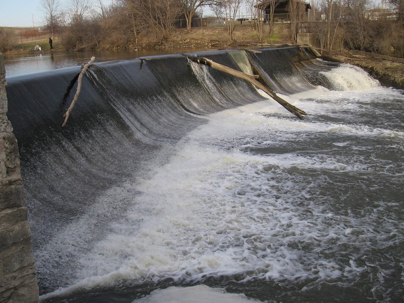
In general, running dams is highly discouraged. Many low-head dams are 'killing machines' at a wide variety of water levels. This dam is a notable exception. A rounded lip, a sloping (not vertical) face, and a smooth concave curve into a horizontal 'kicker' combine to make this as 'safe' as any dam can be. So, yes, the dam has been run numerous times.
At levels below 300 cfs or so, it is boat abuse (grinding down cement on a thin sheet of water). From maybe 300 to 800, it's a quick smooth slip down the face. Above 800 or 1000 cfs, the left half of the dam develops a nasty hydraulic, but the right half still sheets away quite reasonably. Highest presently known run is about 1500 cfs, Christmas day, 2006, no less! Above that, things really look scary (but it probably 'still goes', if you're gutsy enough to send it!).
Again, not encouraging anyone to run it, but the question comes up occasionally.
It is important to note that there is shallow bedrock at the base of the dam, and rocky rubble about halfway down toward the next feature ('Malted Milk'). If you flip at the base of the dam, you are likely to have trouble rolling as you are raked across all this bedrock and rocky debris.
Some other dam trivia: The 'official' height of the dam is listed as 12'. The crest (lip) of the dam is 180' across. It creates a pond of 60 acres, normally holding just 160 acre-feet of water. Paddlers have asked about the possibility of releases from the dam to create boating opportunities. First, the dam does not contain a 'releasable' gate, so it's just not possible without rebuild or major modification of the dam. Second, discounting whatever natural inflow is occurring (which could replenish the pond or extend release times), the millpond would be completely drained in: 6.4 hours@300cfs, or 3.2 hours@600cfs, or just 1.6 hours@1200cfs. Obviously, such a wide variation in pond height would not be allowed due to impact on habitat and water quality above and below the dam. (Even though any such release levels would be well-within seasonal flows, thus not causing any undue effects downstream, and the relatively small impoundment would be replenished within a day at most normal/usual flows, thereby having minimal short-lived effect upstream!)
Some folks have also concocted fantasies about pumping water from the quarry pond to make a 'release' (especially since most years they pump water from the quarry to bring it's water level down from spring highs). The quarry has just 18 acres of surface. Pumping 500 cfs from the quarry (which would take far more massive pumps than are currently used), would drop quarry water level a foot every 26 minutes (even more as the lake went down, since the surface area would diminish as well). A four hour 'pumped release' of 500 cfs would drop the quarry level by over 10'. This would not be tolerated as it would ruin use of the quarry (for swimming and for fishing from the shore-attached floating pier).
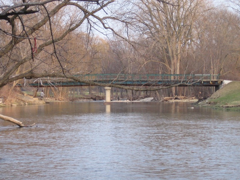
NOTE: at present, the river right eddy (for staging to catch this wave) has numerous dead branches and trees extending into the water. They do not preclude access, but can be a minor interference (or minor benefit for those wanted to 'anchor' themselves for a bit in the eddy). At river-left, as a result of the new bridge overhead, significant large rocks extend a bit further into the flow than was previously the case. At low flows, they will be obvious, but at the flows which make this feature great, it will be important to know they will lie shallow under the surface beneath the bridge. (River right is unchanged, free of large rocks in the water.)
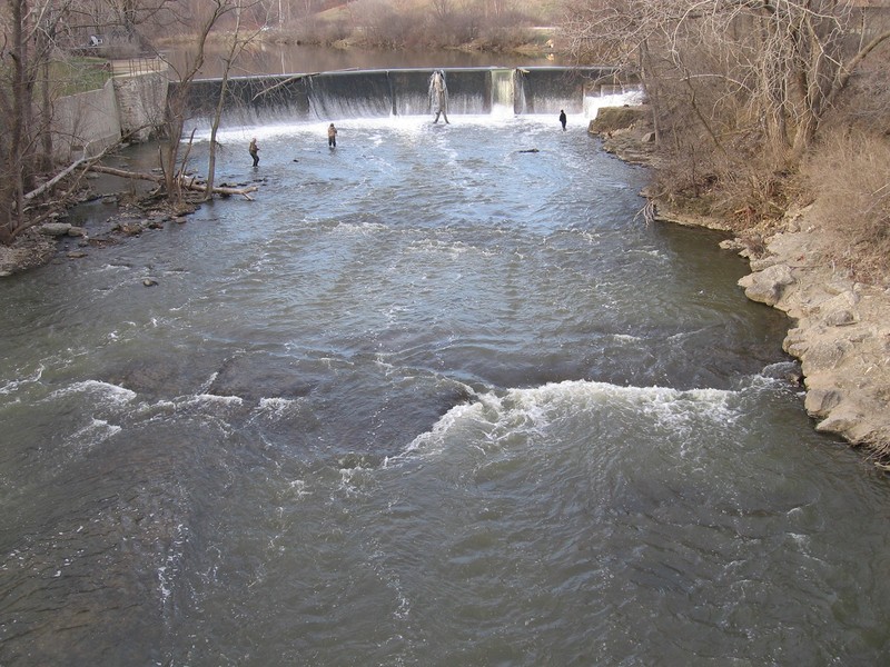
These names derive from a former Racine claim to fame. The Horlick company patented a Malted Milk process, and sold products worldwide for nearly a century.
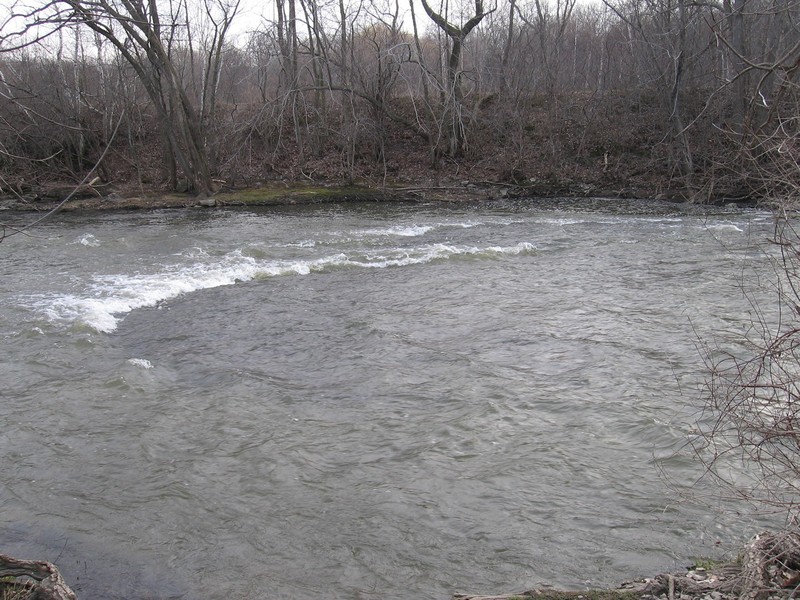
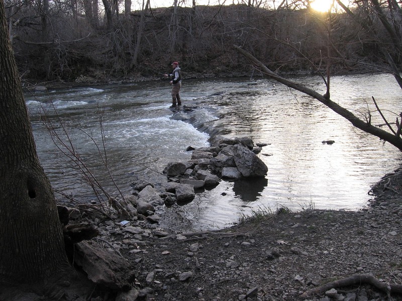
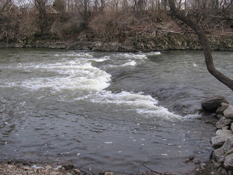
At low to moderate flow (250-800 cfs), sloping bedrock and minor ledge (river-left, right-center of photo) form a playable wave (it barely deserves the same name, so at these levels it's ' Horlick's Extra Lite' or 'H.E.L.').
At higher flow (about 1200-1500 cfs), this dishes out into a wide, glassy wave, conjuring parallels to the sweet creamy beverage it is named for. Soul surfs (with occasional dynamic ripple at some flows) often attract spectatators on the Northwestern Avenue bridge just behind and overhead.
This feature may wash-out (or surge and become chaotic) at flows over 1800-2000. While it may offer some great surfs for those in longer (faster hull) boats, it is less predictable or assured than at more moderate levels stated above.

USGS lists this site being 5.2 mi upstream from mouth. So, for anyone curious about paddling all the way to the lake, that would be your total distance. However, for whitewater paddlers, there is very little of interest beyond our listed take-out in Quarry Park. There may be a few areas minor splishy-splash waves, but predominantly it will be merely swiftwater and flowing water until it reaches backwater level of Lake Michigan, which it does nearly two full miles before actually reaching the lake!
The Root River Environmental Education Community Center (REC) has canoes and kayaks for rent (roughly Memorial weekend through end of September). Many recreational paddlers talk about 'paddling the Root River' as they paddle here. While that is technically correct, at all but the highest flows this area is paddled upstream nearly as easily as downstream! To me, that makes it just an extension of the lake and the harbor (in essence, paddling not a river, but a long narrow bay of the lake).
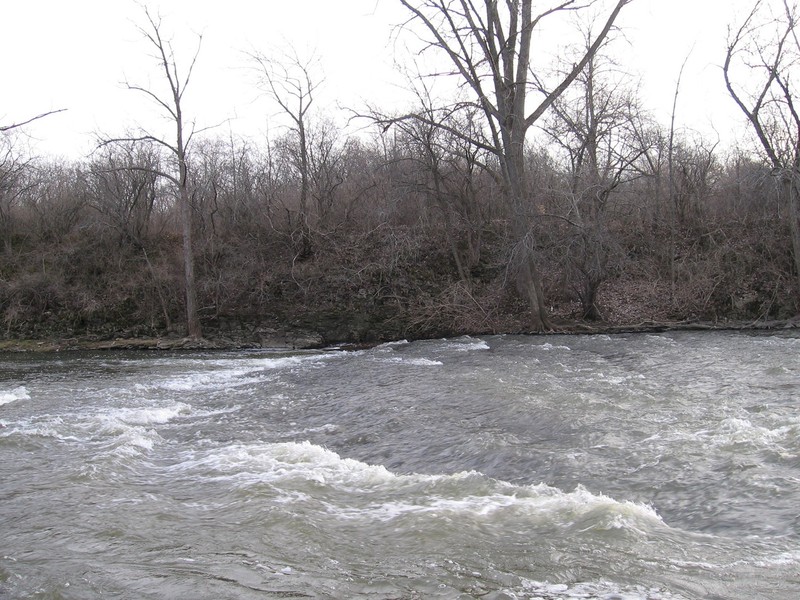
Not far downstream of the bridge and USGS gauge, a large eddy exists on the right, as the river twists off to the left. Above 600 cfs or so, depth and current differential may allow charging into the eddy, plowing down the bow (bow-stalls) or slicing the stern or trying for eddy-wheels. (NOTE: longer 'slice' boats will likely find bottom, so don't vigorously throw down to vertcal!) This can be a fine place for beginners to practice paddling up the eddy, peeling-out into the current, and charging back into the eddy.
Just out of this eddy, the flow encounters a small bedrock ledge, ' Diagonal Slice'. Low-to-moderate flows (~300-700 cfs) allow odd surfs in shallow wrapping currents. At 1000-1500 or so, three distinct pockets allow interesting and challenging surfs. At higher flows, this washes out.
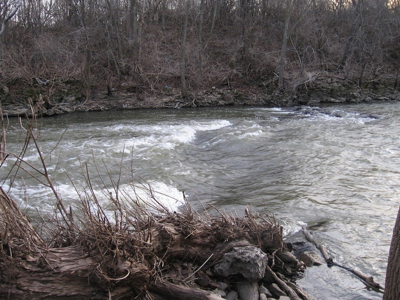
Large cement slabs (no exposed rebar) lie river-right immediately downstream. One slab lies center-river about 50 yards downstream and will be completely covered at most boatable flows, only being of concern if you are upside-down, flailing and failing to roll quickly, or out of your boat while playing here. (See next feature.)
Just downstream of the slight-right-bend below the prior feature, there's a slab of concrete in center flow. At some levels (maybe 800-1200?) it can form a surfable (sometimes even flat-spinnable) wave. Generally it lacks a decent eddy, so it's likely to be COTF (catch-on-the-fly), one-and-done.
The area between the upper features and the lower features is mostly just flat and flowing. However, at levels above 1000 cfs or so, a series of small but sweet catch-on-the-fly glassy waves (riffles) will appear here. Turn bow upstream and paddle hard to stall onto the best among them, or (if you are of a mind and body to) try a few wave-wheels down the small wave-train. (Again, at most boatable flows, this will not be very deep, so 'wheeling' a 'full slice' boat will likely find bottom.)
NOTE: Approach this with some caution, as wood will occasionally hang up on this concrete pier. When it does, it may very visible, with branches sticking above water, or may be nearly invisible (if a single log-like branch is nearly totally submerged). Know how to look for the tell-tale signs of submerged strainers!
A huge hunk of concrete (remnant of an old bridge pier from the quarrying days) lies on river right along the stretch of 'doldrums'. At moderate water levels (maybe 500-1000 cfs), this forms a fine place to practice charging into and catching an eddy, as well as peeling out of the eddy. At the higher end of levels cited, it allows bow stalls and stern squirts on a well defined eddy line. The eddy becomes a bit dynamic (swirly and boily) making an interesting place for novice boaters to learn how to deal with those currents as well.
As flows go above 1,200-1,300 cfs, this will have water flowing over it, and generally causes no feature of any interest.
Unfortunately, flooding in 2008 has pushed this slightly more diagonal to the current, pushing more water toward shore, diminishing the eddy and the play potential (minor though it always was).
This is the first feature on the lower part of the run (the 'short run'). For most runs, at most levels, most boaters will just carry up to put in here, foregoing the upper features.
A shoreline eddy/pool to put-in from (for those carrying up) or eddy-out into (for those coming downriver) exists among the trees on river left, virtually alongside the river-left feature. However it is generally recommended to carry upshore, a bit beyond a chainlink fence, to make it easier to ferry across to the river-right eddy, or (for those coming downriver) we generally recommend just charging into that river right eddy instead of this river left one.
NOTE: As of March, 2026, mutiple willow branches hang low to the water just downstream on river-left. Anyone launching from left shore and/or playing the left wave will need to paddle toward center-river to avoid tangling with these branches.
At low-to-moderate levels (200-700 cfs), a river-right pocket-wave/hole ('Upper Pipeline Right' or ' UPR') has decent width, and a somewhat short shoreline eddy. Surfs and flatspins can be done at will, but you have to paddle hard for the eddy when you come off the wave or you will be flushed too far downstream to regain it.
There is also a river-left wave/hole ('Upper Pipeline Left' or ' UPL'). At low levels, this one is exceedingly shallow and scrapey, and only scarcely worth much attention. As the level rises, the UPR washes out, but UPL builds quite nicely. At higher water (1000 cfs and up) this becomes a sweet surf. Again, there is only a narrow and short shoreline eddy, so you have to come off the wave in good control and paddle hard for the eddy or you will be flushed too far downstream to be able to regain it. Additionally, at the downstream end of the eddy, there are trees on shore, overhanging the river, which can become quite worrisome. Strong, confident paddlers who are swept back close to these trees may be able to 'throw their back into them' and push off to secure the eddy. However, more paddlers (as soon as you realize you are not being able to make it into the eddy) will quickly paddle hard (away from shore) to avoid tangling with them.
At lower flows, the river-left eddy will not extend enough to allow repeat play. As levels reach somewhere around 1100-1200, water spreads across what is normally shore, making it possible (not easy, but possible) to 'pull' your way up this eddy. As levels exceed 1300 (+/-) the eddy gets much more manageable.
NOTE: Trees from shore into the water affect eddies here. River-Left: A tall Ash tree lays across the shore and diagonally a bit into the flow downstream of Tundra, upstream of Lazy Willow. It should not cause any problem for experienced boaters. River-Right: A relatively small buckthorn lies horizontal in the water, perpendicular to shore and to the current, mostly in the eddy below the river-right pocket of Lower Pipeline. Many boaters never head over there, but those who do may tangle with this snag.
Many features on this run come and go (I.E., are good at some levels but either disappear or are lame at other levels), but this one stays present at a wide variety of flows.
At levels up to about 1000 cfs (depending on your boat and your skill), you can paddle upstream in the center-river slackwater, over the back of the wave, to slide in for repeat surfs of the main wave.
At flows above 1,000 cfs, charge hard to the right, blast through the wave, and immediately turn bow-upstream in a narrow eddy along the near-vertical wall of rock. From there it is often possible to paddle up and over the extreme-river-right part of the wave then surf across to the center. (This move may not be possible at some range of moderately high flows, but tends to become possible again at higher flows!)
At any level over about 250-300 cfs, the main wave extends from center to river-right shore. It allows great side-surf practice (especially nice for beginners) and has a natural 'kick' into a left-hand flatspin. Front surfs, blasting and spins against the grain can be pursued by more experienced boaters for variety. It is also interesting to try surfing from center all the way across to river right and back, feeling and reacting to the differing currents in the shallow, steep-faced wave.
As levels rise (from 1000 to 2000 or more), this wave just becomes bigger and steeper, turning into a wall of water (especially the further river-right you go). If this wave doesn't amaze you at these levels, you either are not a 'wave boater' or you've done considerable travel to boat some amazing rivers elsewhere. At some (moderately high) flows, it becomes possible to catch on the fly (drop in backwards, hit the pile with your back and quickly put your boat on a planing angle *or* maybe drop in sideways and ready to brace), but many boaters will be surprised (and frustrated!) by how hard it is to keep from flushing through this wave, however big and steep it may look!
At river left (slightly downstream of the main wave here) lies 'Tundra' (so named because it lies 'below the pipeline' (think the Alaskan oil pipeline), and also to honor the 'frozen tundra' of Lambeau Field, home of the Green Bay Packers). Unfortunately, 'post 2008 flood', this wave has been seriously affected, and is now a tame surf (generally at levels maybe 400-1000 or so). Eddy service for this wave is largely non-existent, making it difficult-to-impossible for repeat play. (You must come of the wave in control, paddling to the center-river slackwater, regain the 'main' (Lower Pipeline) wave, then slide over to 'Tundra' from there once again.)
Not far downstream of Tundra, in the river-left flow, at moderate flows (600-1000+ cfs), a wave forms. A shoreline eddy (bigger at higher flows) can allow some repeat play.
A willow on shore (years and years ago) toppled, and the trunk (laying across the ground, roots still intact) has anchored to the ground and sent up substantial vertical branches. The name of this wave reflects the 'lazy' trunk of that tree. That willow continues to fracture (and often sprout anew).
A minor bedrock intrusion tight to right shore creates a small pour-over/pocket-wave/hole. At flows of 400-1300 cfs or so, boaters who are comfortable putting their boat on edge may surf and spin this short, narrow hole. (Focus on edge transitions to keep from flipping if water hits a low upstream edge of your boat.)
The main feature is center-river, where sloping bedrock forms a wider, smoother wave. Eddies right and left can be used to thoroughly enjoy this area. Minor, tame play ia possible down to 150 cfs and lower, but it's at its best from 400 to 600 or more. As flows push higher, the center-river wave mostly washes out into a fast shallow wave or just a wave-train. The 'pocket' wave will dish-out into a smooth surf at moderately high flows, before washing out altogether at high flows.
In 2023, the namesake willow succumbed to age and gravity, falling fully across this feature. The tree is gone from the water, but its roots and stump remain at river-left, along with remnants one large branch parallel to shore and flow, stil attached and sprouting suckers.
NOTE: As of winter 2025-26, two large trees have fallen on river-right at Right Hip Pocket. They lie mostly on shore, but branches stick into the water. This will negate using the shoreline eddy above or below this feature. Also, on river-left, a tree has fallen on shore and extends diagonally across Good Intentions, precluding play there.
Many boaters will bypass this combination of features. At many levels, these features will not exist, or will provide only tame/minimal play. Catching them is more about river-running moves (holding a good ferry angle to cross the main current a couple of times), and playing a few 'novelty' waves.
Fenceline (FL) is a small bedrock intrusion which extends from river-left to center-river. It can (at low-to-moderate levels) form a minor riffle of a wave, providing very minor (beginner) diversion. At high levels (1000+), this does create a nice trough (fairly wide across the river, but not tall or deep) which can be caught on the fly and will allow surfs and spins. It tends to be a bit of a crease with odd currents which can mess with you. The river is quite shallow here any time the feature is 'in', so if you flip, you are almost certain to encounter bottom.
Right Hip Pocket (RHP) is another small bedrock intrusion tight to river-right. At moderate levels this forms a rather funky little wrapping pourover/wave/hole for interesting surfs and spins (good practice for keeping the boat 'on edge' and switching edges on the spin).
Good Intentions (GI) is a third minor wave/hole which lies tight to river left. Levels need to be moderate to high (500 cfs or more) for this to be worthwhile. It can be a bit of a challenge to play RHP and then try to make the cross-river ferry and catch GI.
Mid-Evil (ME) is a smooth wave that lies centerstream in a left-hand-bend in the river. This wave is generally caught one of two ways. Catch a small eddy on river-right (next to a 'hollow' in the rock wall), then slide out onto a small river-right wave, then out to the wave. (It makes good river-running practice to make the move from GI to the river-right micro eddy, which, of course, is good practice at catching narrow, funky, shoreline eddies.) Alternatively, stay in an upstream ferry in the slackwater downstream of Good Intentions, then slide across a small shoulder-wave which runs diagonally out to center-river.
ME never really builds to a size to allow much other than straight-on front surfs (OK, maybe at some level some boats/boaters can flatspin on it). In spite of that, there are boaters who will relish a 'soul surf' on this smooth wave.
Brink of Evil (BoE) is a sweet small glassy wave which forms just above 'All Evil' at some flows (notably, around 1100-1300 cfs). This is a fine semi-'gutsy' surf for advanced boaters, since you must come off in control and take a couple strong strokes to either head quickly to river-left to skirt the edge of the hole, or hard to river-right to pass through Between-the-Evils or Lesser Evil, or (failing either of those) you will be swept backwards or sideways (with little momentum) into the heart of the Greater Evil.
This is where the freestyle crowd will hang out when the river is running large. This is the most significant ledge on the river (though still tiny by most whitewater standards). It is backed up by a good sized pool, with generally pretty good depth (at least, at high flows ... at low-to-moderate flows, there are numerous shallow areas which you will find if upside down or out of your boat).
When levels are changing significantly, this feature often changes from hour to hour. (Sometimes within moments, right before your eyes!) While the ledge is river-wide, there are subtle differences across the feature which create significant pocket-waves/holes.
River-left is generally a bigger pourover/wave/hole, while river-right tends to be a much tamer wave. Thus, they are referred to (respectively) as the 'Greater Evil' and the 'Lesser Evil'. 'Between the Evils' (center-river, at low-to-moderate flows) can be a funky little spot for surfs, spins, and blasts. As flows rise above 1400 cfs or so, these features merge into one big hole, 'All Evil (of the Root)'.
For truly desperate boaters, this area can provide tame play (front surfs, side surfs, flat spins, blasting) down to 150 cfs and lower! It can make a great place to practice with hand-paddles!
Take-out is at river-left from the pool at this drop. Downstream the riverbed changes from bedrock to rubble and mud/clay/silt, and one encounters only relatively minor riffles and shoals.
Continuing (boating) past this pool would mean having to set a shuttle, whereas one can get the best action by just carrying up within Quarry Park.
A golf course (Racine Country Club) spans the river downstream of this pool. There are signs suggesting they may aggressively enforce trespass on their property, including the three bridges downstream through here (though fishermen seem to regularly tresspass on shore and bridges). Nonetheless, boaters playing 'All Evil' are advised (if they swim, or are otherwise swept downstream of the pool) to be as quick and 'invisible' as possible in getting back upstream to Quarry Park. Be aware that a fairway crosses the river upstream of the first bridge. Errant shots may be a hazard to boaters within the golf course.
Be aware that there are three bridges within the Racine Country Club. The first is visible from the take-out (the pool and eddies at 'All Evil') and should cause no problems (unless the center-river bridge-pier catches a strainer).
At high water (somewhere above 2000-3000 cfs) the second and third bridges will become serious hazards as there will be little-to-no clearance under them. In fact, at some higher levels, water will flow through the bridge railings. While it may be possible to get to shore (or even paddle around the ends of the bridges), many boaters will be in serious danger trying to escape being swept into these bridges.
For a slightly longer trip (and/or if chasing gear after someone swims and 'has a total yard sale'), the next reasonable takeout is in Colonial Park.
After passing under power lines, the river rounds a bend to the east. Take-out river-left at a pedestrian bridge (Root River Pathway), then head north and east to the parking lot.
This will be a shuttle of ~1.9 miles/11 minutes (by car) to get back up to the dam.
Another option for takeout is in Lincoln Park near the Root River Steelhead Facility.
You will pass under another footbridge, then arrive at the parking area nearest the river.
There is little-to-no need to paddle around the bend to the weir ... you may encounter accumulated woody debris, and it's a (slightly) longer carry to the parking area closest to the DNR Root River Steelhead Facility.
This will be a shuttle of 2.1 miles/7 minutes by car to get back to the dam.
Feb 9, 2007
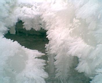
Just thought some of you might enjoy a different appreciation of this stretch of the river. A couple years back, I happened to take a walk there in winter, after enough cold weather that most of the river had frozen over. There were only a few places which remained open. This particular day, these locations were filled with the most amazing ice crystals. A day or two later, the river was frozen the rest of the way, and snows covered the gaps. Once again, nature's art was quite ephemeral . . . often just a couple hours (or a couple days) difference and you've missed the chance to see something amazing. Hope you enjoy.
Mar 11, 2006
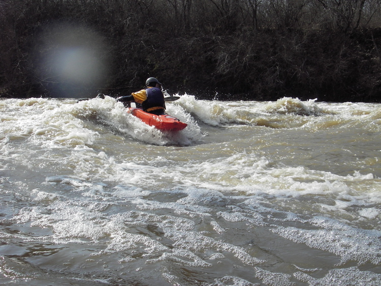
A sweet surfing/spinning wave at this (789 cfs) flow.