Menomonee
C) MenTosa: Hart Park Lane to W.Monarch Place or 4198 W.St.Paul Avenue (2.7 or 3.7 miles)
| Difficulty | II-III |
| Length | 3.7 mi |
| Avg Gradient | 20 fpm |
| Gauge | Menomonee River at Wauwatosa, Wi |
| Flow Rate as of 41 minutes | 14 cfsbelow recommended |
| Reach Info Last Updated | April 10, 2026 |
WARNING: DO NOT PUT ON AT FLOWS ABOVE 3,800 cfs (or if flows are rising quickly and might go above that)!
Numerous bridges become impassible, and are extremely difficult or impossible to portage!
Quick Facts:
Location: Wauwatosa/Milwaukee
Put-in: Multiple options (see below)
Recommended Shuttle Directions
Put-in elevation is approximately 644'
Take-out elevation is approximately 594'
Total drop is approximately 50'
10/85 Gradient Upstream of Put-in: 8.8 fpm
Percent Developed Upstream of Put-in: 62%
(The higher the above two values, the 'flashier' the stream will be! This is a VERY flashy section, with best flows often 3 hours or less!)
Drainage area at put-in: 112 square miles
Drainage area at take-out: 133 square miles
Drainage increase: 18.8%
Class/rating is NEVER enough to decide if you should run a river/rapids! Far more important than gradient and class/rating should be other less-quantifiable 'character factors': continuous versus pool/drop, wide-open routes versus constricted technical rapids, wide-channel (with multiple routes) versus narrow channel (with essentially one route), gradual river banks versus rocky shores or steep-walled gorges, et cetera.
Character: Cobble/rock shoals and compression waves in first half transition to bedrock slides and glassy waves (at high flows) in the mid-portion, then revert to cobble before entering final stretch of 'remediated' quarried-rock bed and banks.
River banks: While the banks in some areas have been laid back, significant areas of the run have vertical rock-wall banks and minimal eddies, making egress nearly impossible. Locations to exit and reload are rather limited!
Typical width: 50-75 ft.
Longest rapids: From bare minimums up to maybe 500-600 cfs, rapids are f

vvvvvvvvvvvvvvvvvvvvvvvvvvvvvvvvvvvvvvvvvvvvvvvvvvvvvvvvvvvvvvvvvvvvvvvvvvvvvvvvvvvvvvvvvvvvvvvvvvvvvvvvvvvvvvvvvvvvvvvvvvvvvvvvvvvvvvvvvvvvvvvvvvvvvvvvvvvvvvv
For low/moderate flows, water quality should not be a problem. However (at best flows for whitewater) boaters should be aware of the following:
These quotes (with personal emphasis and comments added) are from an article many years ago in the Shepherd Express (a local 'alternative' newsweekly) entitled 'Going with the Flow -- How the suburbs are helping close the beaches':
'Tests during rainfalls ... at 15 sites along waterways in Milwaukee County regularly show Ecoli and fecal coliform amounts are thousands of times higher than the EPA standards for beach closings ...'
'... numbers this high are comparable to untreated sewage.'
'One study found ... about 15% of fecal coliform found in stormwater runoff is from dogs.' (I.E., people who do not pick up after their pets!)
'The highest concentrations of E.coli and fecal coliform have been found in Underwood Creek in Wauwatosa and in the Little Menomonee River' (Two of the tributaries of this section of river!)
' people can get sick from water like that, but the illness may be passed off as something else since it isn't that severe.'
So . . . take all that for what you wish to make of it, and make your personal decision about your health risk-tolerance!
^^^^^^^^^^^^^^^^^^^^^^^^^^^^^^^^^^^^^^^^^^^^^^^^^^^^^^^^^^^^^^^^^^^^^^^^^^^^^^^^^^^^^^^^^^^^^^^^^^^^^^^^^^^^^^^^^^^^^^^^^^^^^^^^^^^^^^^^^^^^^^^^^^^^^^^^^^^^^^^
NOTE: As of August 2025, a huge tree has fallen across the river in Hart Park (just as you come around a right-hand-bend). At low flows, it is easily passable, but high flows will make that very dicey and may require portage (to the right), which may not be easy. Highly recommended to look at this before putting on anywhere above it. Park as close as possible to the tennis courts and baseball diamond, walk the paved path between them to get to the river for a look at this snag. If you don't like the looks of things, put in somewhere below it. If you are confident you can make the necessary moves here (with strong current pushing you toward the undercut shore!), feel free to put in above it.
Park at the far west end of the Red Store Lot. Walk across the pedestrian/bikeway bridge and immediately head left into the woods a short distance to put in from low banks in a little backwater bay. At high flows, you may need to point bow upstream to ferry out into strong flow (to get beyond the reach of overhanging shrubbery along shore).
Or, following that muddy trail through the woods, walk about 250 yards / 0.15 mile upstream to start off with a zig-zag wave-train (and, if flows are right, a couple minor surfable waves). There is a pretty good path -- stay on the 'main' trail most of the way ... but hard to describe where to split to the left.
While Hart Park is our 'recommended put-in', there may be times people will prefer or need to use this location. (E.G., if there is an event happening at Hart Park (and/or its sports fields) that has all parking there filled.)
I actually prefer the Red Store Lot put-in for a couple reasons:
The downsides?
Paddlers might ask 'Why not just continue the shuttle straight across Harmonee Avenue onto W.Menomonee River Parkway, and put-in from someplace along it?' You could, but that is a 'high traffic' area (vehicles on the Parkway, bike and foot-traffic on the Oak Leaf Trail). Twice when I have put in along there, a well-intentioned good samaritan has taken exception to what we were doing, taking photos of our car/license plates and ourselves. I've had officials (the police) tell us 'I can't let you do that here!' (There used to be a city of Wauwatosa ordinance against launching anyplace within the city, but not everyone knows it was repealed some years back.)
So ... why deal with that hassle! All you are missing is swiftwater and a relatively minor wave-train.
Anyone putting in upstream of Hart Park should be aware that downstream of the the Harmonee Avenue bridge is a pedestrian mall/bridge in the heart of Wauwatosa. Two bridge piers in the river regularly accumulate branches and whole trees. Approach this area with caution (especially at high flows). Better yet (if putting in anywhere upstream of this), SCOUT this bridge while you are running your shuttle to be aware of the conditions here. If any wood is present, watch carefully to determine if there are branches extending just under the surface that may snag your boat.
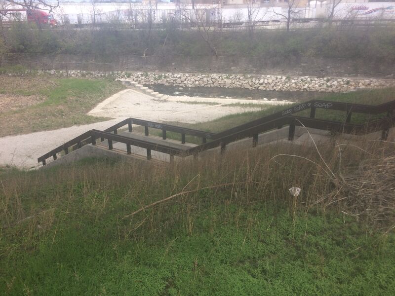
If passage is completely blocked, stairs at river-right may allow exit from the river. However, you'd be perilously close to the danger of the blockage, there won't likely be much of an eddy to conveniently get out, and you will likely end up walking east (either across a bridge on the Oak Leaf Trail, or not crossing the river, walking to the very end of the Farmers Market parking lot) to get to a spot where you can easily get down to water level to put in.
OUR RECOMMENDED PUT-IN: From State Street, turn South onto 72nd Street, cross the tracks, then immediately turn right. Drive past the football field, baseball field, tennis courts, and two volleyball courts.
Just beyond the second volleyball court, park where you see the railings around a storm-drain outflow at the river's edge. This gives you a very short carry and an easy staging area to get into your boat then peel-out into the swift currents right at the head of the Hart Park Rips for a rip-snorting class I-II start!
NOTE: As of fall of 2025, a HUGE tree has dropped totally across the river from the left bank. Scout that location by walking downstream to the bend before putting on here!
Another option for put-in is to go into the parking lot southeast off of Harwood Avenue before crossing the railroad tracks. (You should be able to find this by searching for 'Tosa Farmers Market' on your mapping/routing app.) Drive as far back into that lot (downstream) as possible, park, and carry into the woods to put in off low shores at the water.
This will be almost directly across the river from our listed 'recommended' put-in in Hart Park. It offers no real advantage over that location (described next), other than if an event in Hart Park has that parking all filled up. It also offers no real advantage over the Red Store Lot (described previously) other than when wood blocks passage on the water when you check the pedestrian plaza/bridge just upstream by the tracks.
A sweeping right-hand bend occurs as you enter Hart Park. The inside (right) of the bend is shallow rocky shoals, while the outside (left) is deeper water with a fine wave-train. Be alert (look well downstream) as you near this area, as it has been the site of trees falling or hanging up and blocking much of the current.
Best strategy is to come into the bend at far river-left, so you can see further downstream around the bend. However, angle your bow toward right shore (and slightly upstream), so when you paddle, your strokes take you away from the badly undercut left shore!
Do not get too near the left shore, as there are often roots or overhanging branches to catch you or your boat.
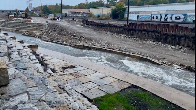
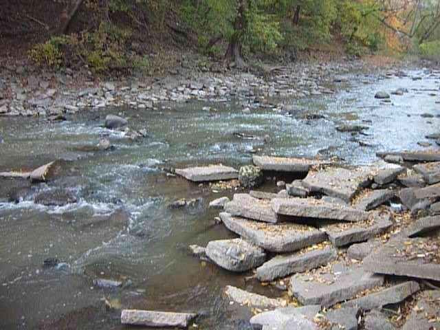
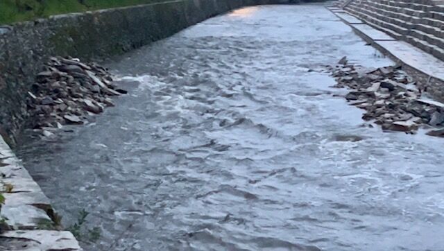
As shown in the photo, the riverbed and banks through here are strewn with cement slabs. The coarse, angular cement would be brutal to anyone upside-down or out of their boat through this stretch. DO NOT TRY TO STAND OR WALK IN ANY CURRENT THROUGH HERE! Scraped, bruised, and battered ankles and shins at the least, and foot entrapment at the worst, are very possible here!
As you approach and pass under another bikeway bridge, the river takes a sweeping bend to the left. If you have high water, you will encounter a fine little wave-train through this area. A few waves (mostly upstream of the bridge) may allow catch-on-the-fly surfs (pretty much just front-surfs, not likely to allow spins or any other moves ... maybe enough depth at high flows to ender-out).
NOTE: at high water, it may be advantageous to stay to the left (out of the strong current) to keep from being swept too qiuckly into what lies downstream. As of 2025, there have been trees and branches (from river-left) hanging low to the water. You need to ensure you have clearance through here!
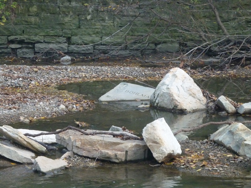
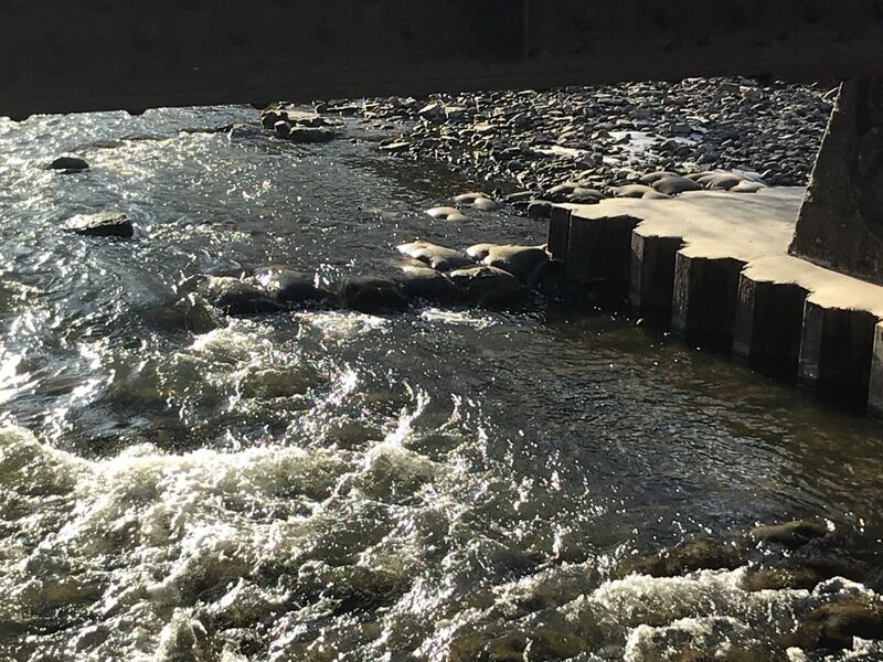
Honey Creek enters from river-right. Playboaters may be inclined to try some 'vertical' moves (bow-stalls, stern-squirts) in the confluence of current. It should be noted, however, that there is (right at the confluence) one stray failed gabion (wire basket filled with rocks), as well as the sort of rubble pictured in the low-water photo.
With the gauge being right on the section, it will VERY accurately reflect actual flows in the remainder of this section. (Since Honey Creek enters not far upstream of the gauge, that would have to be subtracted out to represent flow on the earlier section of the run.)
Keep in mind that USGS flows are posted (at most) once per hour, and flows are 20-30 minutes old by the time they are posted.
While there are times (in spring) when flow can remain fairly steady for 24-hours or more, most often this river is VERY flashy (after significant rain).
So, no matter what the gauge says, the actual flow will have changed by the time you are on it!
Some boaters use a 'short-run' option, putting in from the parkway at this location. This cuts off about a mile of mostly swiftwater and low-grade riffles, to get the final 1.6 miles containing the best gradient.
This could also be a good option for 'extreme high flow' runs, since a few bridges upstream can end up deadly (either being very low to the flow, or with water flowing through bridge structures). The railroad bridge (at about 47th & State Street) is still of concern, and would need scouting before putting on at any flow which may exceed 4000 cfs.
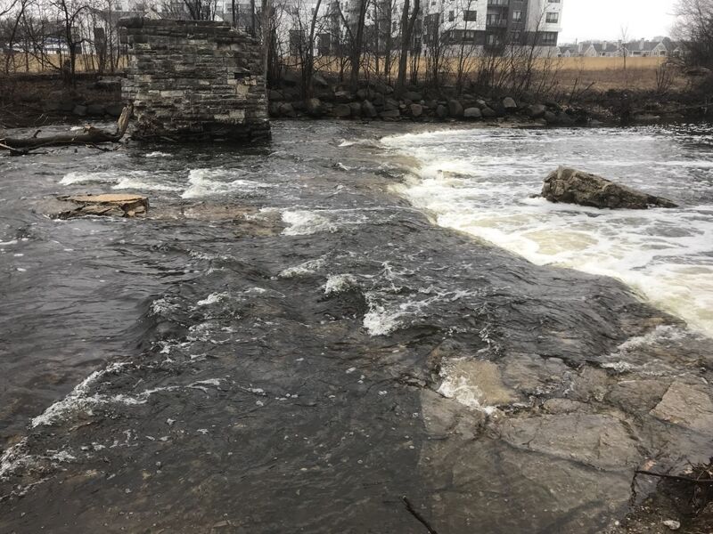
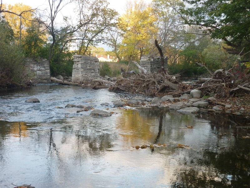
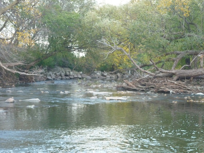
A long-gone bridge in Jacobus Park had a pair of bridge-piers splitting the river. May of 2020, rains lifted the river over 5000 cfs. That flow pushing on a massive collection of trees was more than the right pier could withstand, and it was torn out. A bit of the footing remains and causes a disturbance at levels under 700 cfs. The bulk of the bridge pier still lies in the pool just below where it once stood. As with the pier footing, this will be visible at low flows, but will be covered at flows above 700-1000 cfs.
With that pier knocked down, this area is far less likely to become blocked with wood. However, I have seen trees hang up on the pier submerged in the pool, as well as river-right below the pool. At high flows, if you are trying to catch the right eddy, you may be pushed perilously close to that woodpile.
You may wish to scout this location while you are running shuttle to be aware of the currents and waves present, to have your approach strategy solidly in mind.
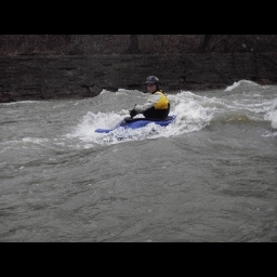
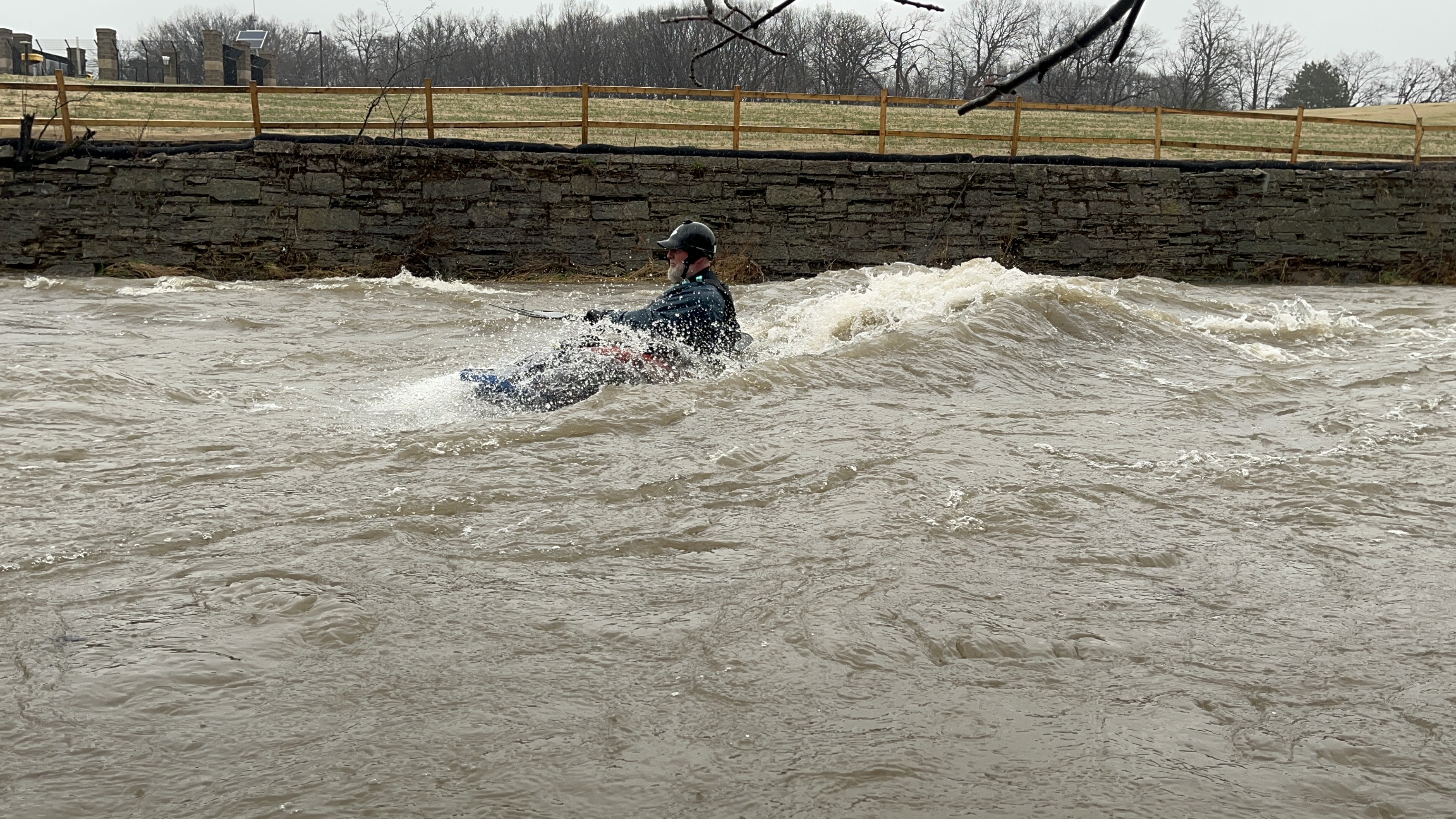
At flows of 400 -800 cfs (possibly down to 250 and up to 1000 cfs) a smooth wave lies center river just downstream of the remaining bridge pier. The wave is shallow 'up front' (no vertical action here!), but there is depth in the pool below. At higher flows the wave washes out and there are wild swirls and boils ripping through the pool, allowing stalls and squirts (if you are inclined to do so in highly questionable water quality).
Midway down along an area where the river-left bank has been re-sculpted (circa 2015), where numerous saplings have been planted, be on the lookout for a large center-stream rock which is cleft perpendicular to the flow.
At low-to-moderate flows (under 1000 cfs or so), there will be water flowing through the cleft, which is barely boat-width. It can be a cute and funky maneuver to charge (from river-right) toward the slot to try to funnel through the crease, trying to avoid a knock-down or boat-pin. (It's a fairly benign spot to release from and recover, if you are not entirely successful in your endeavor.)
Approaching this area, the river-right shoreline changes from grass/weeds/shrubbery/dirt to become layers of bedrock. The streambed also becomes bedrock and the fun begins! The river repeatedly accelerates down slightly angled rock, then stacks up series of waves through here.
They become playable somewhere in the 400-500 cfs range, and become more and more fun as levels increase. At flows around 1,300-2500 cfs, there are a couple big powerful waves, likely with at least one wave breaking nicely on itself. A shoreline eddy river-right allows repeat play for strong boaters in control enough not to be swept downstream.
This can be done as a PnP by parking street-side (next to a fine maintained flower garden, across from the house at 5813 W.Trenton Place) and flagstone/rock steps (with a makeshift handrail) down the steep embankment. You'll want to carry upshore a bit to appreciate the approach to this wavetrain.
NOTE: A project in 2024 (to reduce flooding on State Street) left the vertical stonework walls from here to Hawley Road virtually untouched, so the waves here should form precisely the same as before.
The name (an intentional play on words with a feature on a popular major river elsewhere) alludes to the location at Hawley Road, as well as a reference and tribute to the Wood Veterans Hospital and Wood National Cemetery which is not far to the south of here.
At good flows, as you approach Hawley Road bridge, one or two playable waves can form at certain levels. They will be COTF (catch-on-the-fly), one-shot play.
BTW, this location can be a river entrance or exit point (if you can get ashore upstream of Hawley), but be aware that the rock rubble which lines the river-right bank is very dangerous footing. Rocks may shift underfoot, and a slip or fall here (especially if you are carrying a boat) would be very painful. Rather than trying to go up/down the rock rubble, enter/exit a bit upstream of the bridge, where there is a bit of break in the trees. Footing may be a bit slick when conditons are damp, but at least there aren't angular rocks.
Immediately after the Hawley Road bridge, the 2024/2025 project has removed the deteriorating vertical wall from river-left from here down to the freeway overpass, replacing it with a stepped shore of huge blocks of quarried rock. Midway down this stretch, the right wall is also replaced with huge blocks of quarried rock, but with much wider steps. This has maintained the former stream width at flows under 1200-1500 cfs, but allows flows to spread wider above those flows.
======================================================================================
Construction continues (as of 2025.10.19), so we'll have to see how various features form once the project is complete and temporary diversion walls are removed. Presently, temporary barrier/walls in the river and crushed stone roadways for equipment in the river channel narrow the river and are creating a couple new features (described below).
Just a short ways downstream from Hawley Road, look for an eddy at river-left. A crease and a wave here can allow some surfs and enders. Best flows are likely ~500-1000 cfs. Depth is generally adequate for short (6' +/-) playboats to go vertical, while 7' or longer boats will likely tag bottom on going full vertical. The eddy should allow easy repeat play before proceeding to next features.
*** This is MIA (Missing In Action) during the construction. We'll have to see if it returns once the construction project is complete.
Too some, DPW means Department of Public Works. For boaters of this river it means D oyne P ark W aves!
*** These are very significantly modified while the temporary diversion walls are in place, and will likely be affected by the stepped walls (replacing totally vertical walls) on both shores in this area. At present (October, 2025), a temporary wall (to make a drivable 'road' at river-left) creates a sweet wave/hole which gets deep and retentive at high flows (when it will likely be totally catch-on-the-fly). At low flows, it is a fine surf, and may be repeatable if you are aggressive and catch an eddy to paddle back up. ***
===========================================================================================
***The following description is being left intact for now, but will be updated once the project is complete and we have a chance to visit the river at a variety of flows.***
===========================================================================================
Sloping bedrock creates the sweetest set of waves at flows above 1000cfs. There are virtually no eddies so these are catch-on-the-fly.
At 200-400 cfs, expect minor playable features. At 400-900 cfs, you may start to see potential. At 1000+ cfs, SWEET glassy waves appear. Above 2000 it becomes sloshing surging slapping chop! There may be some surf-on-the-fly, but more is chaotic roller-coaster ride!
A group of playboaters wanting to surf these sweet rides will have to do their best to find whatever slackwater along shore as they can, to let each (one-at-a-time) take their turn catching the waves they can. As lead boater(s) drop off the first waves, other boaters slip out of their shoreline micro-eddy to try for their rides. Slackwater at the end of the series allows lead boaters to wait as the rest of the group works their way down.
Do not proceed downstream until all boaters have regrouped. Vertical stone walls make rescue or recovery difficult if anyone suffers an 'out-of-boat' experience. About 0.1 mile downstream, the river-left wall has been knocked out to create some flood-plain. Any swimmer and/or their gear which cannot make it to that river-left shore will likely not be recovered until well downstream (perhaps long beyond the take-out).
This is a *NEW* feature, apparently created during the construction. A massive amount of slab rock is littered in the river. As of 2025.10.18, much (all?) of the slabs have been cleared from center-river, pushed into piles along both shores. A minor wave forms river-right at some low flows, and has an eddy for repeat play (such as it is).
It remains to be seen whether they will be left in this configuration, or (more likely) they will be removed prior to completion of the project.
A temporary wall (movable cement dividers) narrows the river by nearly half. The left half of the river (to this wall) has been filled with broken rock to form an access road for heavy equipment. As a result of that narrowing (and whatever the riverbed is doing here now), a fine breaking wave is forming at many flows (all the way down into mid-100's!). This is likely to be COTF (Catch-On-The-Fly), one-shot play at any flows over 200 cfs.
===========================================================================================
*** We have no idea what will exist here once that project is completed, and the 'road' and temporary diversion walls are removed. We'll keep you posted! ***
After passing Hwy.41 high overhead, the river swings left down rock-rubble rapids, leading to a railroad bridge with a pier splitting the flow.
Watch for woody debris hung up on the bridge pier and (if present) head river-left to the inside of the bend. The current is less strong and the riverbank slopes, making it possible to get out if need be. (River-right is a vertical rock wall.)
In the right (main) channel, at some flows, there can be a wave at the upstream-edge of the bridge.
Unfortunately, repeated highwater events have precipitated the need for quarried rocks to be emplaced around the bridge pier. As a result, there is no longer an eddy here, and any possibility of play is now COTF (catch on the fly).
The pool (downstream of the bridge) is deep and will have wild swirls and boils at flows over 1000 cfs. At high flows, be aware that strong current downstream heads straight toward shoreline rocks cemented in place (armoring the banks) which can snag branches and trees. Charge hard to the inside/right to avoid being swept into the wall!
As you pass under the 45th Street Bridge, you encounter an area of 'remediated' streambed. Wall-to-wall cement has been removed and large quarried rock lines the river bed and banks. This creates a swift but minor choppy rips. Anyone so unfortunate as to flip or swim here is likely to be punished by multiple impacts with shallow quarried rock in very swift currents.
Do not try to stand in any strong flow, as foot entrapment, bruises, broken bones, and worse are a serious possibility. (If you don't know what 'foot entrapment' means, and the serious danger that it represents, please do yourself a favor and do some research on it.)
From State Street, turn south on 45th Street (crossing the river), then bear left (between railroad tracks and a long warehouse type building). Proceed all the way to the end of the building, then to the left to park at the end of a stub street at the river.
(This is behind the building(s), where (at least as of Jan.2026) there are heaps of shredded tree mulch in a large open gravel area.)
Take-out is possible river-right, midway down an area lined by quarry rock.
Convenience of egress is very dependent on water level:
At flows under 1000 cfs: eddy-out river-right in slackwater and anchor yourself against a rock. Carefully get out of your boat, holding onto it or having a buddy do so, to carefully stand onto the rocks. Pick up or drag your boat across the rocks to the paved area. You need to be VERY careful walking across these irregular-shaped quarried rock. A slip or fall will be painful!
As flows near or exceed 1000 cfs: from a ways upstream paddle tight to the right bank, sliding down a paved shoulder, and into slackwater for your exit. (You will not have to deal with the rock rubble shoreline!)
At higher flows (near and above 1400 cfs): all rocks will be well covered, and you can easily charge the break in the wall for your landing.
That said, most folks will continue downstream for a couple of additional features.
Just beyond the prior access, the river veers to the right, encountering a few good waves, including one spot which may offer challenging play (though shallow angular rock underlies the riverbed, so not a place to flip, roll, or swim).
The river takes a jog to the left and passes under a railroad trestle with two bridge-piers anchored into the cement shoulders of the river. At high flows, water flows between and to the outside of the bridge piers. Strong currents will push hard into the right bridge pier. Passage between the piers may be a tad tricky, but you'll have the option to go to the outside of either bridge pier. On the downstream side of the bridge, at moderate-to-high flows, a fairly tame wave/hole can occur for a little end-of-run surf and spin.
Paddlers may opt to forego any of the downstream take-outs by taking out river-right immediately at this railroad, then walking 0.1 mile upstream to the 43rd Street / Monarch Place take-out location. (NOTE: if the river has been at high flows, this concrete walkway could be underwater, or may be wet, muddy, and slippery. Use caution.)
A project to remove the uniform cement channel (replacing it with quarried rock) through nearly a mile of this river created a breach in what had been a vertical wall, allowing access (egress) from the river.
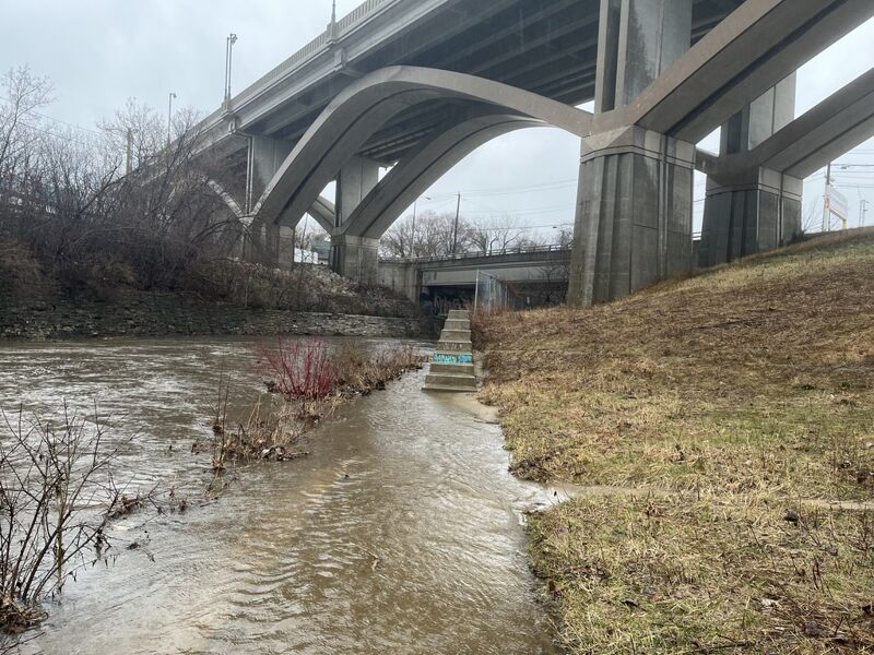
A short dead-end stub of a road (off of Bluemound Road) has plenty of parking, both in a cul-de-sac area and under the Bluemound Road bridge, as well as parking for 2-3 vehicles upslope nearer the pictured landing area.
****************************************
2025.08.15 UPDATE: This take-out area has been increasingly sketchy, with people dumping all manner of trash under the Bluemound Road bridge, vandalism and other matters of concern. As a result, it we no longer recommend leaving a vehicle here. Use the other listed options (upstream or downstream).
Parking is streetside (in a community known as Piggsville) near the playground in Valley Park.
(This adds about 0.4 mile of flatwater from the former 'recommended take-out'.)
With the area under Bluemound Road becoming increasingly sketchy, this is the next most convenient and presumably somewhat safer option.
Exit at river-left before passing under the railroad and the freeway. At most flows, gravel shoals (or shallows) should allow exit from your boat. Scale the wall, walk up slope on the grass, scale another wall into Valley Park.
As the river is crossed by a railroad a third time, bridge piers split the flow, and the river is narrowed a bit. There is some unevenness in the riverbed which has created minor play at this site at some flows. Unfortunately, I've so seldom bothered to paddle down to here that I don't have detail on what flows (if any) make anything meaningful here.
Immediately downstream the river passes under the Interstate (I-94), and into the area surrounding the baseball stadium (American Family Field ... formerly Miller Park). (Anyone interested in continuing the run down to Miller Stadium parking areas had best consult Milwaukee Brewers schedule to ensure there is not a game going on).
After the second railroad trestle, you'll pass under Interstate-94 and will be flanked by parking lots for Milwaukee's baseball stadium (now branded 'American Family Insurance Park').
Most of the area is gated when there is no game or other event, and will be full (and likely cost you) when there is a game or other stadium event. Thus, we find it hard to recommend continuing past our listed take-out.
Downstream to the harbor, the river will be featureless, flat, flowing water at all but the highest flows.
Oct 22, 2013
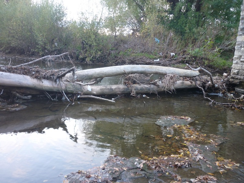
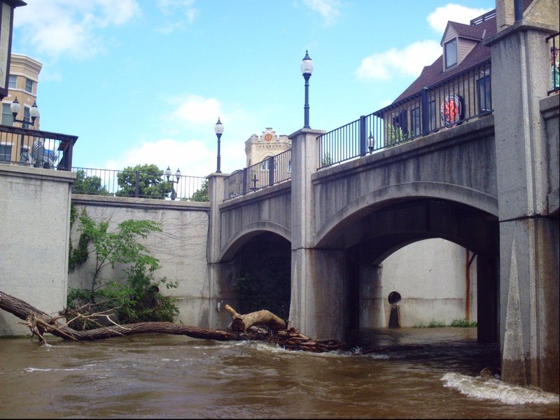
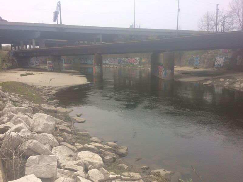
Always take wood in the river as a serious and potentially deadly concern. This shot of Jacobus Park bridge piers shows the center of the snag which has been in place all of 2013. Look closely at left and right to see all manner of branches sticking out at odd angles. If you made the mistake of running through here, you could easily have your boat snag on one of these branches, or (in a kayak) your boat might go under a branch which might catch you across the torso or face. Without very, very careful scouting first (to know as much as possible about what lies below), any potential thrill of running snags like this is completely outweighed by the potential danger you are putting yourself in.