Tyler Forks
A) Moore Park to Vogues Rd (up to 8.5 miles)
| Difficulty | II-III+(IV) |
| Length | 7.8 mi |
| Avg Gradient | 37 fpm |
| Gauge | Tyler Forks River at Stricker Road Near Mellen, Wi |
| Flow Rate as of 1 hour | 5 cfsbelow recommended |
| Reach Info Last Updated | September 7, 2020 |
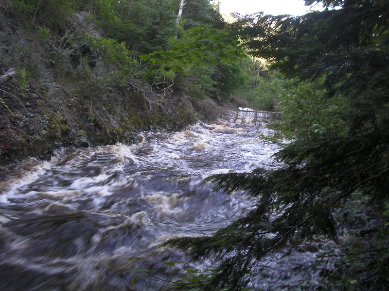
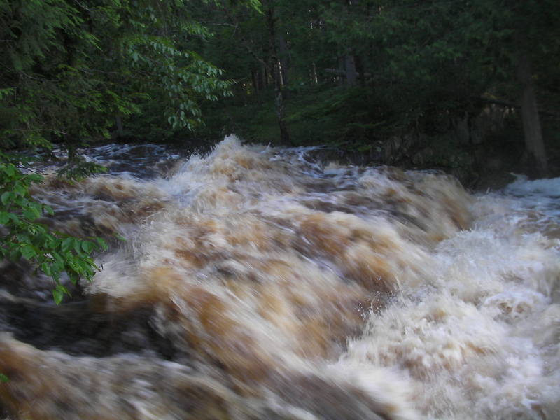
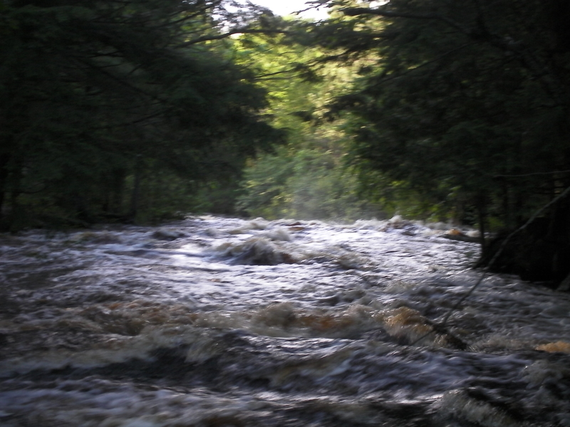
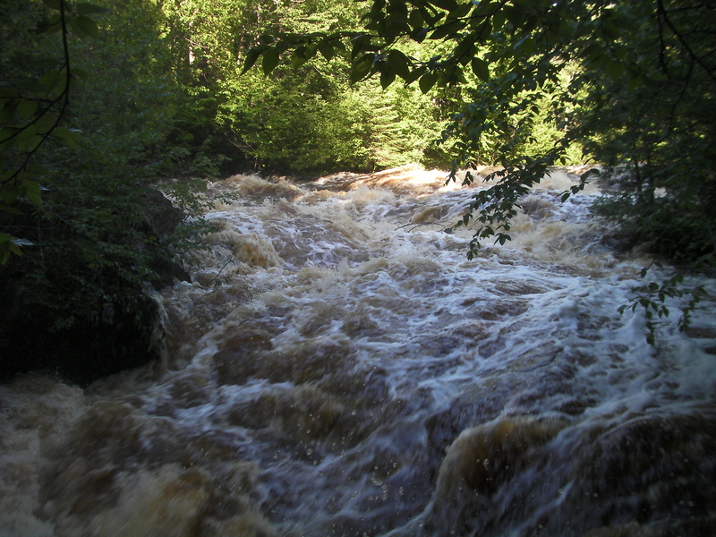
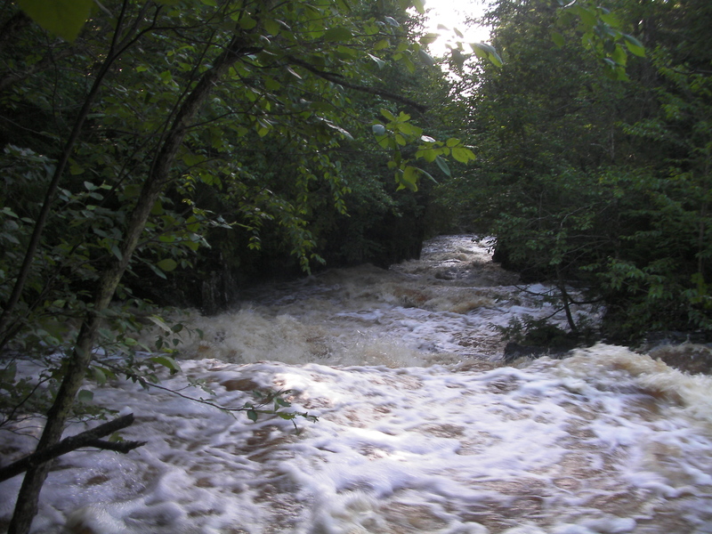
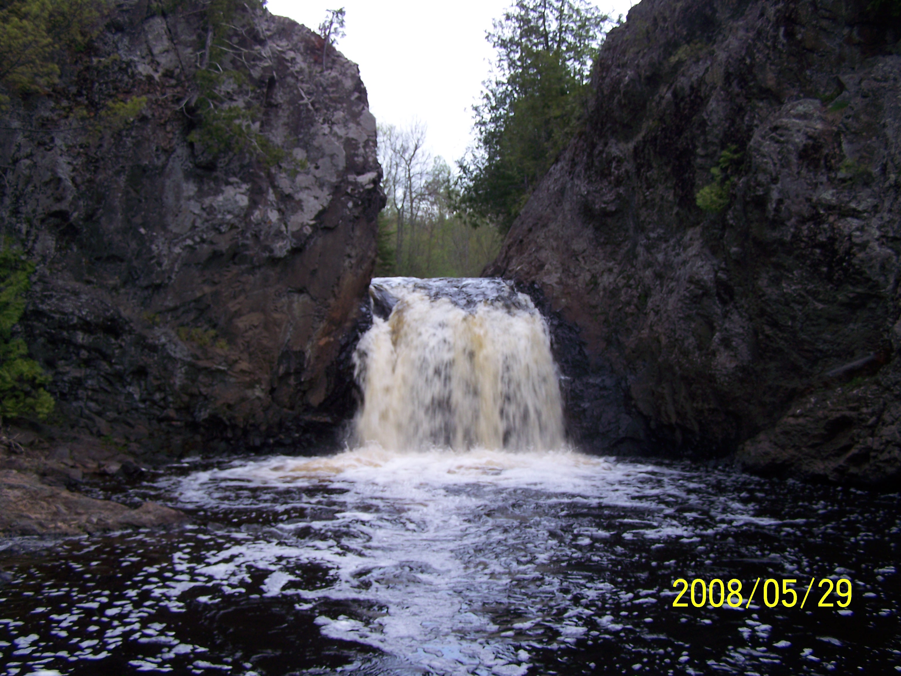
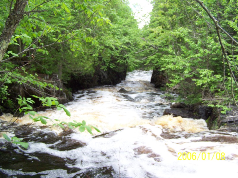
The Tyler Forks features boulderbed rapids. interspersed by sections of alder swamp, with several steep bedrock drops. Wren Falls (towards the end of the reach) may be one of the most scenic small falls in the state.
This reach begins with the 'dells' of the Tyler Forks (local name unknown) which is reached by carrying upstream from the end of Moore Road. The river rapidly drops 40+' through a sequence which begins with fast class III feeding into a stepped ledge of 8'-10' and finishing with a fun drop through a rockwalled canyon/dells. This is the most technically challenging drop on this reach. Those who don't wish to run this should put-in at the Hwy 77 bridge as there is only flat water (and likely some deadfall/snags) between the bottom of this drop (at Moore Road) and the bridge.
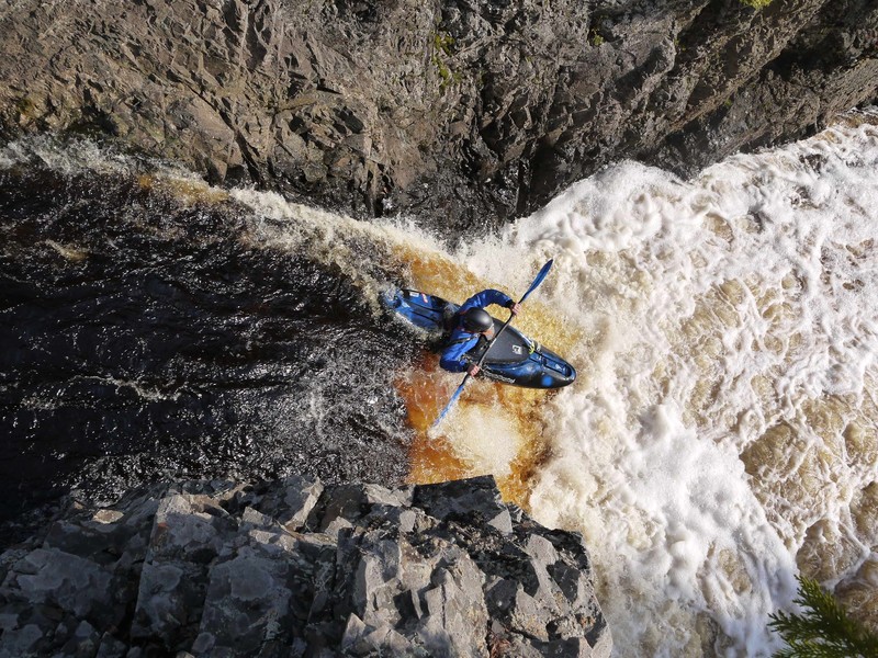
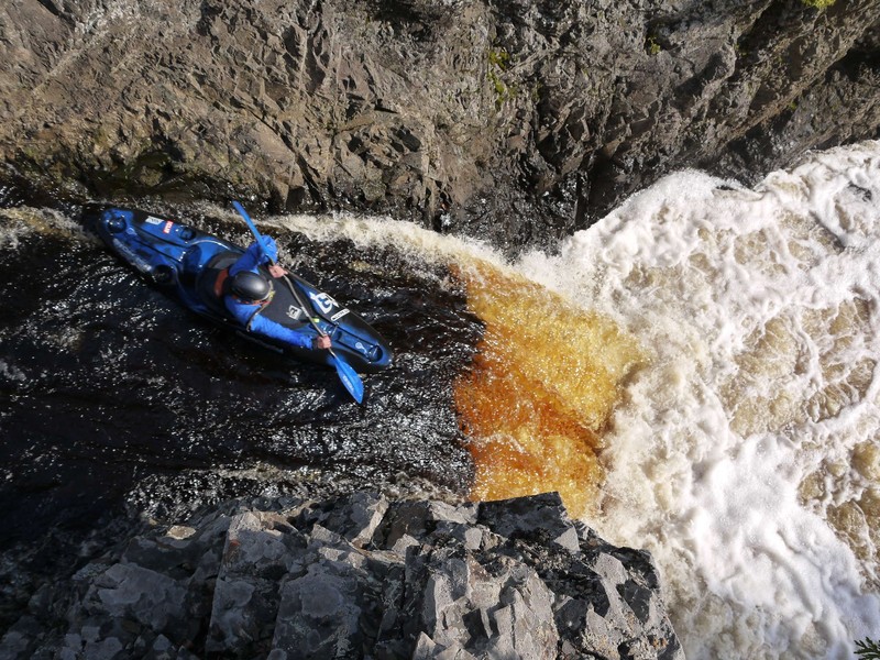
From Hwy 77, the current picks up again through read-and-run boulderbed with one ledge of about 4'. After about a mile and three quarters, things start to slow down as the river enters a section of moving water through alder swamp. When the current starts picking up again, be aware that you are approaching Wren Falls. Wren is a rolled lip vertical of about 10'-12', dropping between vertical rock walls into a deep pool, a very beautiful site and great photo op. The falls approach is pretty straightforward, though you will want all the speed you can muster to launch and avoid the hole at the base. Below Wren there is about a half mile of class II followed by a short stretch of moving water to the Vogues Rd take-out.
The 'dells' of the Tyler Forks (local name unknown) is reached by carrying about a quarter-mile upstream from the end of Moore Park Road. The river drops over 40' in about a quarter-mile through a sequence which begins with fast class III, feeding into a stepped ledge of 8-10 feet, and finishing with a fun drop through a small rockwalled canyon. This is the most challenging drop on this reach! (It may push into class IV territory at good flows!) Those who don't wish to run this drop should put-in at the Hwy 77 bridge, as there is only flat water between the bottom of this drop (at the end of Moore Road) and the bridge.
The following YouTube video (courtesy of 'edo0776') shows multiple runs through the dells:

You will park here and walk up for a look at (and possible run of) the dells. On the river from here down to Hwy.77, it is a full mile of low-gradient (no rapids!) moving water and meanders, with likely problems with deadfall and snags. (Possibly a mandatory portage or two? or more?) It may be a tough call whether to deal with that known and unknown, versus the time and hassle of taking out, securing boats in/on your vehicle(s), and driving down to Hwy.77 to 'restart' the rest of the trip from there.
Just prior to Hwy.77 there is a defunct Soo Line railroad (now likely multi-use trail). After passing under this and Hwy.77 you'll pass under powerlines. This is the alternate put-in, for those not running the upper 'dells', or those not paddling the mile of meanders in between.
USGS lists a sampling site this location citing drainage area of 38.2 square miles.
Immediately around the first bend, you'll encounter a fine ledge to start things out.
A quick zig-zag and minor lead-in waves bring you to a bigger ledge/slide, after which action quickly subsides to riffles and waves, then flat/flowing water for nearly 3/4ths-mile.
Coming round a bend, flatwater again turns to riffles and waves, signaling the approach to the next good gradient.
Much less than the first two drops, but a welcome back-to-back couple of ledge/wave/holes in an 'S'-turn, followed by more riffles and waves.
Just about the time you think the action is going to revert to too tame, you come around another zig-zag to find a sweet slide.
Not far downstream, the river 'zigs' left and down a quick chute, then 'zags' right down a second chute. Downstream, waves continue for a bit before once again subsiding to riffles and flat, moving water.
The action totally dies out as you reach a very sharp zig-zag, and Erickson Creek (very small trib) enters river-right. This is the sign that you are in for over a mile of flatwater meanders in swampy territory. (Sorry 'bout that.)
Likely to be virtually unnoticed, Javorsky Creek enters from river-left. If you do happen to notice, it's your sign that these swampy meanders are coming to an end. (Yay!)
A slight acceleration of current, and a slight right bend lead you into the next sweet chute, which could (at some flows) have a significant wave/hole. A brief pool ensues, quickly followed by a ledge/wave/hole, then (as the river twists to the right) another set of ledge/wave/holes (while twisting back left again) before action subsides for a bit.
As the river twists right, it trips across a couple ledges (or a quick rapids). Downstream, you again enter an area of looping meanders and flatwater. There will be occasional random shoals, riffles and rips, but no real rapids for about two miles.
Perhaps a welcome change (from flatwater, minor riffles and rips), a minor stretch of boulder bed begins here. (It may or may not actually form 'rapids'.)
A rocky outcropping on river-right (just after a tight left-hand horse-shoe bend) signals approach to more interesting action once again, just around the next (right-hand) bend!
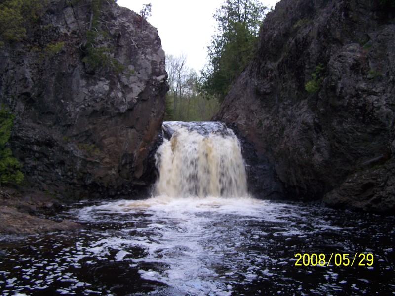
When the current starts picking up again, you are approaching Wren Falls. Wren is a rolled lip vertical of about 10-12 feet, dropping between vertical rock walls into a deep pool, a very beautiful site and great photo op. The falls approach is pretty straightforward, though (at some flows) you will want all the speed you can muster to launch and avoid the hole at the base.
Following Wren Falls, the river twists tight right and then left, spilling across rocks and chutes as it goes.
A rock wall (river-right) signals a rocky chute with more large rock midstream below.
One final ledge/hole/chute, and it's all done. The remaining distance to Vogues Road is merely swiftwater. (If you can find a spot on the road up to Wren Falls which is wide enough to pull off and park, you may be able to cut off (some of) the final mile.
Apr 12, 2020
Ran 4/11/20 @ ~375cfs . Note the road down to PI wasn't fully plowed of snow which added another 1/4 mile to the hike up to the dells. Portage following right next to the river, RL up above the dells. There is a small eddy RL upstream of the main section, but there is some more narrow moving water that could add potential fun. The dells are great fun and provide a great beautiful intro to the run. The alders aren't that bad and about 20 min of boat-bush-pushing got us to the bridge. From here down to Wren there are a few sizable drops interspersed with long sections of flat/moving water. The lead in the Wren is pretty obvious and eddies were catchable on the fly RR. Note that there is a 12' log over the full lip over the falls. A real shame. This was a mandatory portage at this level, but at lower levels a maneuver may be possible RR under the log. Sketch. From here down to the TO is fun boogie, holes, and haystacks. There was no other mandatory portages and a low amount of wood as compared to other creeks in the Mellen area.
Apr 30, 2015
We ran this at about 240cfs on 4/24/15. The dells were a bit grungy, but fun. This can be a fun river to run if you avoid the over grown meanders, which will be the longest 1.3 miles that you ever paddle. Due to the matrix moves you will be endlessly repeating as you paddle though this overgrown section. The dells are worth the run, but definitely drive up to the alternate put-in afterwards. Wren Falls is fun as long as you use a well timed boof stroke. **Trying to pencil over the fall isn't a good idea.** The boil line is a ways out there(ten feet). Running the fall river left of center may lead you into the wall. The current near the wall, at this flow, is neutral to flushy, so if you find yourself here more than likely you'll have time to push off the wall, roll and paddle away.