San Lorenzo
Felton (Henry Crowell State Park Bridge) to Ocean at Santa Cruz
| Difficulty | III-IV |
| Length | 10 mi |
| Avg Gradient | n/a |
| Gauge | San Lorenzo R a Santa Cruz Ca |
| Flow Rate as of 19 minutes | 18 cfsbelow recommended |
| Reach Info Last Updated | December 27, 2023 |
The San Lorenzo is a pretty and very accessible river. While runnable for most of its length, the three mile stretch from a mile downstream of the bridge into Henry Cowell State Park, to the takeout just north of the where Highway 9 crosses the train tracks, contains the most gradient. Its worst quality is undoubtedly the water quality – much of the run stinks due to local sewage regulations, or a lcak thereof. If you can tolerate the smell, there are some fun rapids and pretty sights to be had.
From the Henry Cowell bridge, the first mile is primarily riffles and bushes, with little difficulty. Soon after losing sight of houses and trail access on river left, the gradient picks up. There is an alternate put-in here on river right, with access available from a large unmarked pull-out of concrete, and a steep trail down to the river.
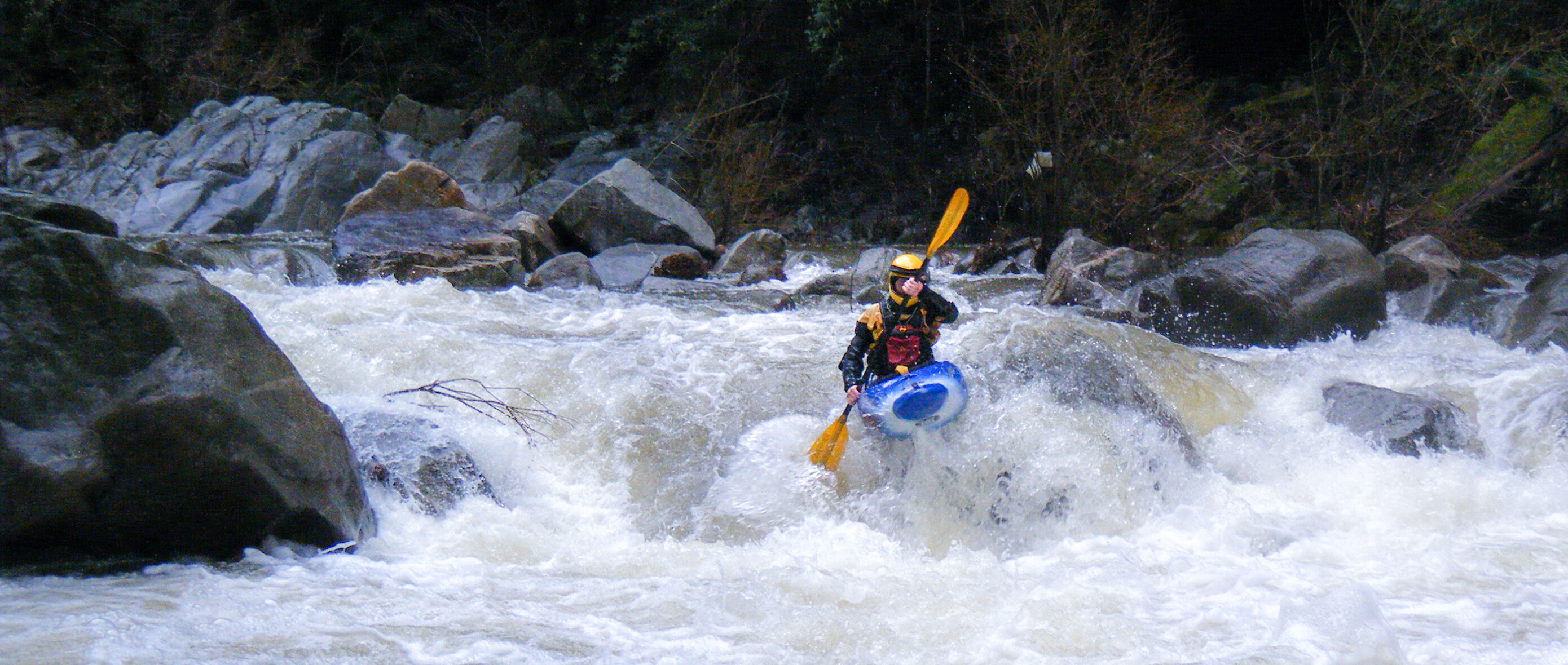
From here, you cannot see or hear the road or any houses until you get down to Paradise Park, a mile or two up from the city of Santa Cruz. It's a narrow redwood canyon with steep rock walls in some places to give a gorge feeling. The core three mile section has constant rapids with only small pools separating them. The size of the rapids increases, each bigger than the last, until you reach the falls, the largest drop.
An alternative put-in is available about 1-1.5 miles downstream of the Henry Cowell bridge, allowing you to avoid the flat moving water. Look for a large pull-out where a steep bike trail drops down to the road opposite the river. A steep trail drops straight down to the train tracks, and another trail to your right heads down to the river.
The December storms (2002) changed several rapids, most significantly the largest drop.
The first couple rapids are small and easily boat scouted. A moderately good play hole is on the right at the third ledge where the river is split. Several more small rapids offer nice slalom practice, rock spins, and the occaisional boof. Always watch for wood.
<...Jan 8, 2026
Ran this around 400cfs. Fun, approachable level that is mostly class II with the biggest rapids (waterfall + the one before it) pushing to a class III. Overall character of the river was friendly. Gradient is low at first, picks up through the gorge, and then mellows out again afterwards.
Only 1 mandatory portage at this level, down closer to the bottom of the run after the gorge ends. The river braids and then goes through bushes that were unpassable.
In inflatable kayaks, this is a fun run that is fairly beginner friendly. In a hardshell, it is low-intermediate, as the rapids are somewhat continuous in the gorge, making a swim potentially unpleasant.
Based on this experience, I would say the 300-700 is probably the sweet spot for a first time run. Enough water to be fun, but not pushy.
Jan 5, 2026
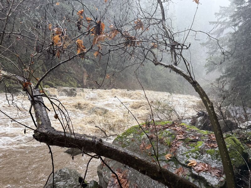
On the drive down to SC it was pelting rain, prompting numerous checks of the level: 2000 cfs and rising… great? After arriving and some deliberation, we decided we’d give it a go at the high flows. By the time we set shuttle and got on the river it was around noon, and the flow was roughly 2500 cfs and still rising.
We put in at the Felton Covered Bridge and took out at Santa Cruz Memorial Cemetery, after some uncertainty regarding the parking situation at Paradise Park. If we were to run it again, we would put in at the bridge headed toward Henry Cowell State Park and take out at Paradise Park (if possible). This would have cut out some flatwater and blind corners into brush.
From previous trips, we expected the character of the rapids to be mostly Class III with one Class IV. The wildcard was wood. We had heard a few days prior that there were five river-wide log portages, which made us nervous given the high flows.
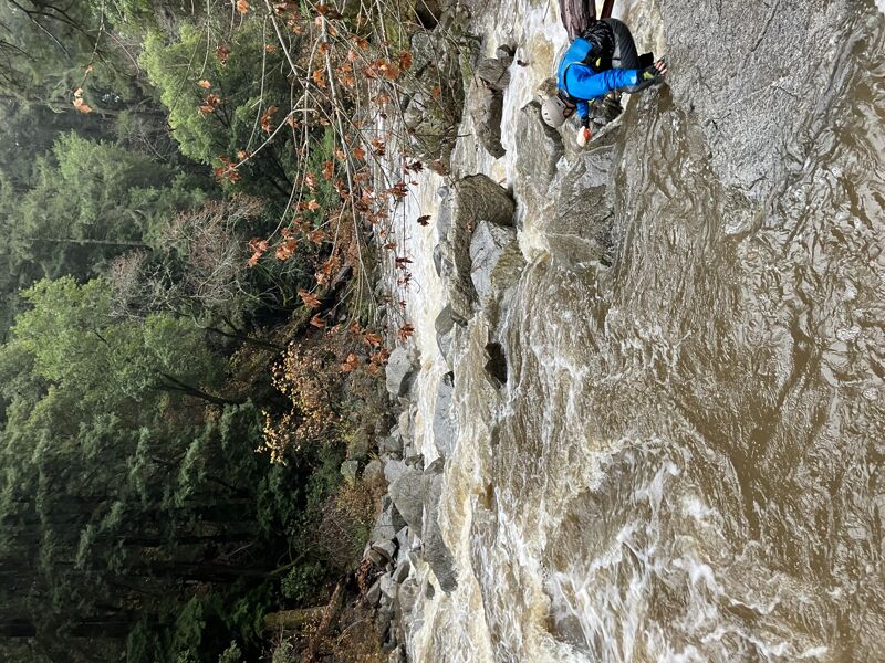
After putting in, we encountered our fair share of blind corners with questionable brush and wood situations. It was fairly common for the river to split into a couple of channels around bushes. We used a combination of following where most of the water was going and some guesswork to make it through. The worst of the early wood forced us to jam our boats through some brush on river left. Nothing terrible, but it definitely made me nervous for the rumored log jams downstream.
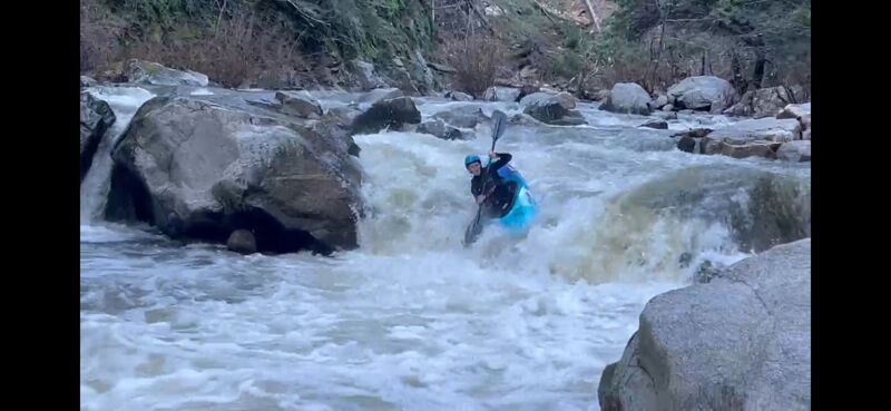
When the rapids start, they get going quickly. At our flow, most of the gorged section ran fairly continuous, requiring careful eddy choices to boat scout most of the drops. The character of the gorge was large, pushy Class III with some big features that were relatively easy to avoid. After the river does an S-turn through some pushy rapids, it makes a left turn where there is a very large redwood tree fallen across the river. We were able to easily duck under it on river right. This tree can be used as a marker for arriving at the rapid known as The Waterfall (not actually a waterfall—just the largest rapid).
After passing under the tree, there is a long straightaway where we were unable to boat scout due to the steepness of the river. We pulled into an eddy on river left to scout the drop. (You might also be able to scout on the right, but you could be committing yourself to ferrying above a bus-sized hole, so I’d recommend the left.)
At our flows, Waterfall Rapid was a meaty Class IV+ with some stout holes. The top hole on the right was particularly impressive—and scary. We scouted a sneak line on river left that consisted primarily of Class III moves but was relatively narrow, with big mama holes not far away. Two in our group ran the sneak, and one portaged and set safety on river left. A swim here could be consequential because Waterfall leads directly into the next large rapid.
The rapid below Waterfall looked like a straightforward wave train, but upon closer inspection (while running it), we found it to be more technical, with several large features to avoid. We boat scouted this rapid.
After Waterfall and Waterfall’s “little brother,” the river flattens out and most of the rapids become pushy Class II+ wave trains. There are also more sections that flow through brushy channels similar to the beginning of the run, but with more gradient. Some of these channels and blind corners resulted in nervous eddy catching and awkward boat scouting. Up to this point, all of the brushy sections had runnable channels, but a couple of times we bounced over river-wide logs—which could pose a serious hazard at lower flows.
Eventually we came across a large log jam (we knew there would be at least one). After hopping out on river right and walking downstream a couple hundred feet, we found a narrow channel that went through, with a few submerged logs that were mostly out of play at our water level. This would almost certainly be a mandatory portage at lower flows. You can recognize the channel by the downed redwood tree to the right of it (its probably the largest downed tree ive seen in my life).
After the log jam, the river is mostly flat, which made boat scouting for wood easier. We meandered downstream, passed the Paradise Park bridge that we wished we could take out at, and eventually took out at the cemetery.
After finishing the run, we were surprised to realize there weren’t any mandatory wood portages at our water level. There were many sections that were almost mandatory portages, but ultimately everything went through. This prompted us to jokingly refer to ~2600 cfs as the “perfect flow.” Of course, since wood in rivers like this is constantly changing, on a different day or at a lower water level there could easily be 10+ wood portages—so tread cautiously.
Overall, we enjoyed this section and would come back. The sewage smell was not nearly as bad as we expected (perhaps diluted by the high flow), and there were a few quality rapids. If there were less flatwater + tree dodging—and if the gorge were twice as long—it would be a truly great run. Alas, it’s still worth a look, and made for a fun day on the river.