Clear Creek
2. Blackberry Mountain Road to DNR Take-out on Cartecay River
| Difficulty | I-III+(IV) |
| Length | 4 mi |
| Avg Gradient | 60 fpm |
| Gauge | Fausett Creek Near Talking Rock, Ga |
| Flow Rate as of 1 hour | 1.56 ftbelow recommended |
| Reach Info Last Updated | May 21, 2025 |
So your friends are running the Cartecay AGAIN for the 100th time this weekend and it just rained. The idea seems horribly boring so you are thinking there must be something else you can do.
There is an alternative, Clear Creek. Clear Creek is the small stream that confluences with the Cartecay at the base of Clear Creek Falls. Perhaps you have looked up it wondering what could be found upstream in that flood scoured riverbed.
Clear Creek was once fairly congested with trees, but the massive and I mean massive 2004 floods following the hurricanes gouged the creek bed free of almost all strainers and debris.
There is no direct gauge for Clear Creek. The nearest stream Fausset Creek is a good indicator. A quarter inch of rain is good enough to make it run since the watershed has been badly damaged by the floods. The creek is as a result rather flashy and drops quickly.
To reach the put in turn right onto Lower Cartecay Rd. after leaving the ÂRiver Right put in from the Cartecay and drive about 200 yards. Take a right on Old Clear Creek Rd. Drive till you see Parker Dr. on your left. Go right here and almost immediately turn right again on Blackberry Mnt. Rd. Basically Stay on Blackberry Mountain Rd. as it twists and turns around along the ridgelines. You will eventually drop down into a river valley with a small bridge this is the put in. If it looks good then you have enough water. The takeout is at the Cartecay DNR takeout. Just go back to Lower Cartecay Rd and go left. Drive till the Rd. ends at Hwy 52. Take a left and drive till you see the DNR sign at the dump and go left again. Drive around the dump and down to the Cartecay river takeout. (THIS IS NOT THE BLACKBERRY TAKEOUT). The shuttle takes about 20 minutes.
Clear Creek could be a great beginner creeking trip. The only downsides are the unreliable water and possibly less an optimum water quality. The creek does drain some farmlands so expect the runoff to have some input fr
...
The left line is a sliding drop.
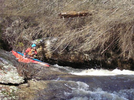
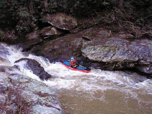
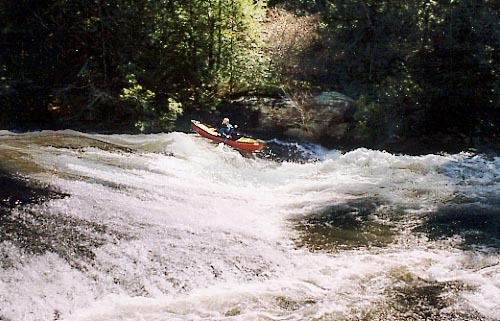
The first major rapid is Timber Falls. Apperently a rd 'Timber Falls Rd.' comes fairly close to this drop on river right. The rapid is easy on both river left (single drop) or river right (double drop). The lower water line is on river right.
After a small pool below Timber Falls the river makes a very strong turn around a blind drop. The top drop is a slide with a bad pinning rock on the right. The rapid then becomes a narrow flume and ends in the pool above Headless Horseman.
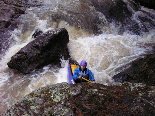
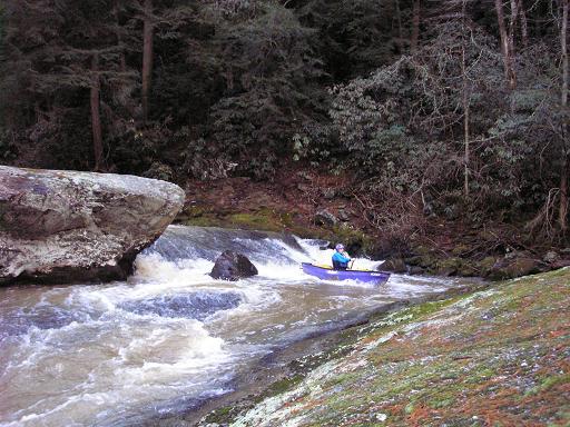
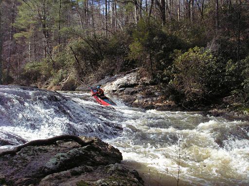
A solid class III rapid. Headless Horseman is a slide into a vertical ledge with a pinning rock on the right and a big undercut on the left. At higher flows the rock on the left will smack you in the face.
You can see the undercut ledge on the left.
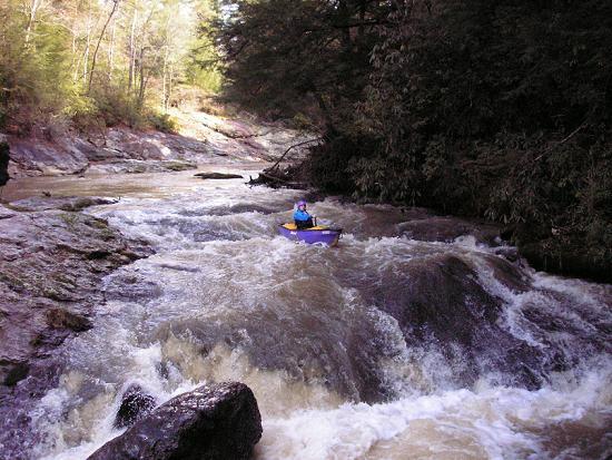
Finale is a slideing drop that is fairly straightforward and easy on the left or center. The right line is obstructed with rocks and a tree.
Clear Creek enters the Cartecay at the base of Clear Creek falls. An easy walk to the top lets boaters run this drop.
Nov 9, 2013
We did a DNR run the other day and even though Clear Creek was low I wanted to hike up and check it out. For anyone who runs the Cartecay because of convenience but also wishes there were more rapids on it.....the hike up to Clear Creek is worth it. Can't wait to go back when there's more water in it. Makes for a long day on the water if you do the Cartecay first and play any at all, so start early.
Aug 25, 2013
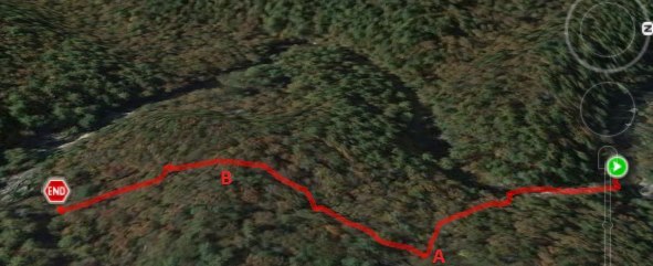
I built a trail from Clear Creek Falls on the Cartecay River to Timber Falls on Clear Creek. Many thanks to the hard work put in by Jason Butler. The Trail is .31 miles long takes about 7 mins to walk and the hike has a total ascent of 80ft. This puts you in just above Timber Falls and you get to drop 52.5 ft over .63 mile doing four class 3 rapids. So from the Cartecay at Clear Creek Falls - run the falls then eddy out on river left and follow the trail up beside Clear Creek. This part of the trail is an old horse trail or something and leads away from the creek. You will see a small creek bed on the right of the trail. Where this creek bed closes up to where you can cross it the trail we built begins a steep switchback for about 20 feet high and then the trail cuts off to the left once at the top. Until we get it blazed follow the downed tree limbs lining the trail. Jason Butler and myself got 2 laps in today after building and then ran into Woody Janssen, J.d. Grogan, and Craig Davison who joined us for our 3rd lap. It definitely adds to the fun of the Cartecay. On the map the Steep climb is at A and is a gradual climb to B then it's all downhill. Hope ya'll enjoy so go get some laps! UPDATE August 25, 2013 - The trail is marked with a Yellow Blaze to make it easier to follow as it turns up the hill away from the old logging road... The flood a few weeks back cleared all the debris from all rapids and they are all good to go. It also removed several feet of the soil from the rocky banks and cleaned the view up some. It's really nice in there now. Ferns have overgrown on the trail itself as not many people have traveled it. Please take the time to hike and paddle this great stretch of river when you run the lower Cartecay.
Feb 28, 2009
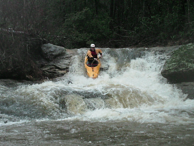
Chuck Kirk running Timber Falls
Notice the log behind Rob's top hand. This must be portaged if you are going to run the left line. (At least on 2/28/2009)
Notice the log behind Rob's top hand. This log blocks the right line at Timber Falls (as of 2/28/2009). To run this line you must portage the log or carry back up after you run the left line.
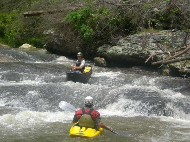
Shawn getting a face full.
May 8, 2006
The water level was great when we put in but it really went down FAST
This turned into an ELF run but it has a lot of potential. We barely got under some strainers that would be a real problem at higher water
at this ELF level there were a number of pinning rocks in the main channel.
Jan 9, 2006
The flume finishes up the final part of rapid number 2
The final rapid is approximatly the same size as Clear Creek falls on the Cartecay, which is just 100 yards downstream.
Timber Falls is a two stage rapid. The first drop is shown here. The lower water line is on river right but you can also run down the left side of the island.