Caesar Creek
Caesar Creek Lake to Little Miami River
| Difficulty | II |
| Length | 2.6 mi |
| Avg Gradient | n/a |
| Gauge | Caesar Creek Near Wellman Oh |
| Flow Rate as of 52 minutes | 4.62 ftbelow recommended |
| Reach Info Last Updated | June 22, 2020 |
Gwen English provides (2004-08-30 11:50:19):
To the putin: From Waynesville, take Route 73 east, crossing Route 42. Turn right onto Clarksville Road, turn right into the 'gorge'. If you cross over the dam, you've gone too far.
From the putin to the takeout: Come back up out of the 'gorge', turn left onto Clarksville Road, turn left onto Middletown Road (before you get back to Route 73)and follow it down the hill where it dead-ends at Corwin Road. Turn left onto Corwin Road. After crossing Caesar Creek (the bridge is the takeout), turn left into a park/parking area and park there.
I would call this no more than a low class II, but it is a fun run. The only thing to watch out for is possible strainers and low-hanging branches.
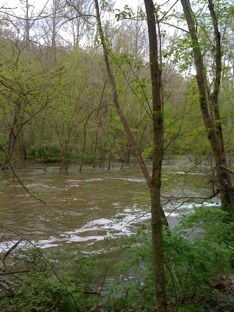
Low water runs are possible at a little over 6' on the gauge at which the river is an easy class 2. There is some easy play and quit a few good spots for beginner whitewater boaters to practice ferries, eddy turns, and such. At higher levels (9'+) many of the features wash out and some decent sized wave trains appear. At flood levels even the wave trains start to wash out and thoughts of swimming start to look pretty ugly due to the push of water into the trees.
Be careful of strainers especially near the take out bridge.
Scenery is quite nice through the entire run and the water quality is decent as it spills from the bottom of Caesar Creek lake. You'll see lots of fishermen on low water days so please give them room. Typically they are only on the first and last 1/2 mile or so of the river.
Ron Metzger (5/15/19)
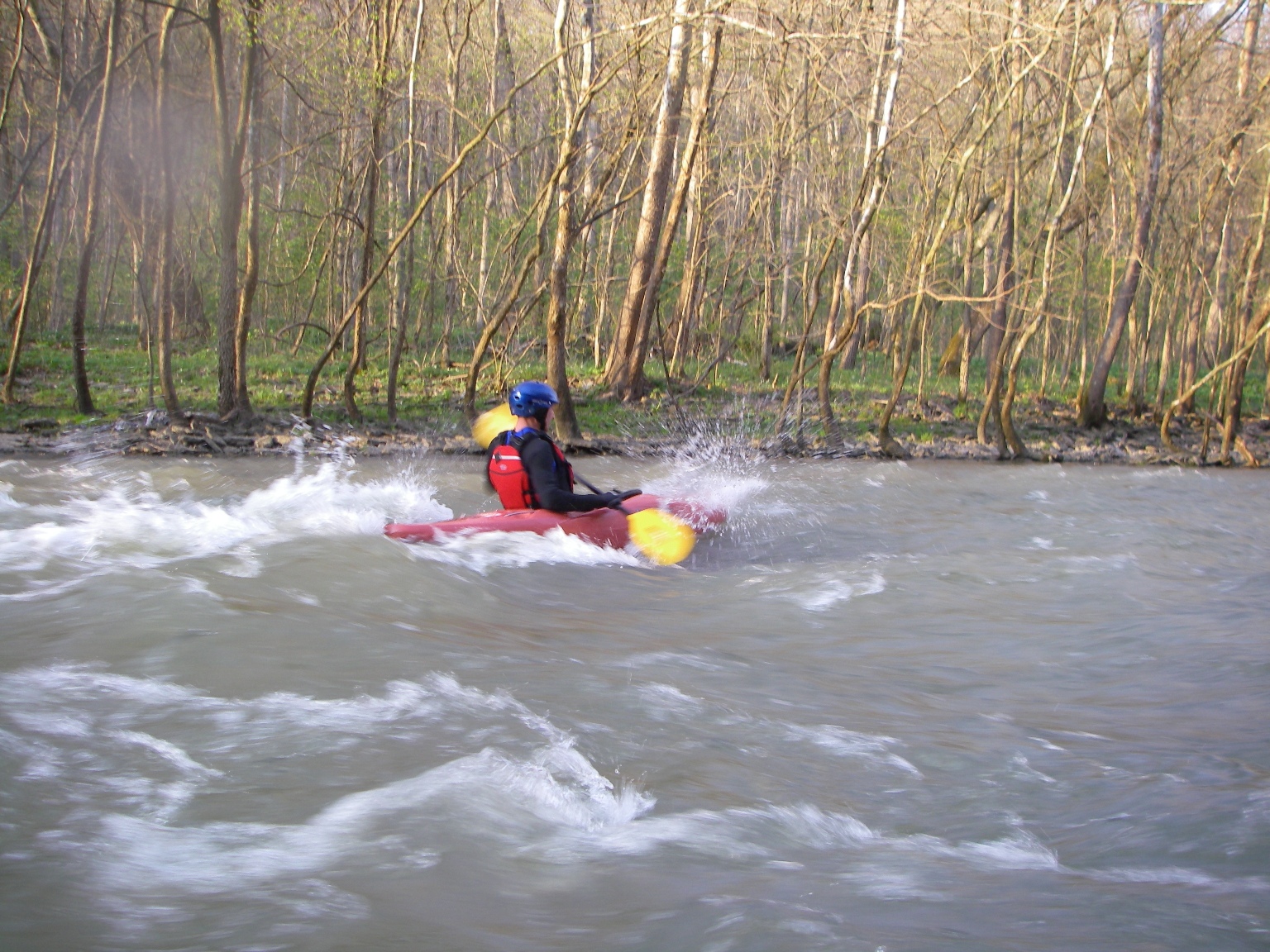
The following video shows a typical run of this stretch at 7.5 feet on the gauge, a good level for easy play.
Feb 6, 2025
There is a tree across the creek about 2 miles down. You can launch over it at 7.93 feet, but suggest caution. 2/6/2025
Mar 22, 2021
Ran this with my GF 03/21/2021 at just under 8ft on the gauge. Stream was clear of any major strainers. There is one kinda nasty looking pile of debris river right of the first rapid but plenty of room to the left to get around it (though it looks narrow when you first approach).
Its a pretty fun run with fast (but cold) water. Wish it was longer. The takeout at the bridge kinda sucks. Its not really a developed takeout and you come out onto the bike trail so you can't pull a vehicle up. I'd probably consider packing a lunch and floating on down the little miami on a nice day instead as its a pretty scenic area.
Aug 17, 2016
All clear at mid 7ish feet, some strainers partially restricting lines but none fully blocking river.
Jun 18, 2016
Correction to my report 6/12/16, water level was 6.5 ft. No small detail as it would not be runnable @ 1 ft. lower.
Jun 12, 2016
Made PFD today ( 6/12/16) @ 5.5 ft. in Katana, Axis, OT Trip 10 loaded for afternoon paddle. Had no problems w/ wood. Didn't portage or wade. Watch for boulders. scout on fly, our lines good but @ higher levels I'd say when in doubt, scout. it's a gorge. We're not very experienced but enjoyed it a lot. Def no Ca-Brew or what-ever they call it. Bring a pole, the fishing has to be awesome. You'll have it to yourself. Be safe and respect it, these my parts. Remember, you're on your own for all three miles of it, but extra innings can be had out on the Lil Miami. hit me up if you want.
Jun 1, 2011
When Caesar Creek is 'too high' the majority of the waves wash out and the river flows into the trees. Not much fun.
Apr 19, 2011
Put-In Access Rd GPS - N 39.489640 W 84.06221
Take Out GPS - N 39.49299 W 84.10167
^-- Take out is on SW side of bridge, walk SE across bike path & Bridge back to parking lot (20yds) - Per request of park rangers, please don't use the East bank next to the parking lot - it's a nature sanctuary.
Water flows nicely with very few issues, ran it 4x in last week @ 8.5ft - it's a quick run but easily doable twice in 2/2.5hrs
Apr 14, 2011
At 8.7 feet, the two main rapids of the run are good. Also, if you have a playboat, bring it along. After the second big rapid, there are a couple islands. The normal line around the first is always to the right, but the second, the line is usually to the left. However, if you run the second island to the right, there are a couple boulders, the second of which forms a great eddy line for squirts and plowing enders. Depth is pretty good as well. Just check the depth before you start flipping to make sure you are bumping your head.
Feb 20, 2011
For video of this run:
http://www.youtube.com/watch?v=GZQS5B40Xq0
Level was 7.5 feet on the gauge, a good level for easy play.
Feb 20, 2011
The strainer after the first ledge has moved downstream and the river is easily run straight down the middle/little to the right. Also, most strainers have moved out of the way for an almost clear run down the entire river. At the last little rapid (just before the bridge and takeout), the strainer is out of the way now and you can run it down the deepest part of the river.