Milwaukee
C) Estabrook Park to N.Riverboat Road (PnP or up to 3.6 miles)
| Difficulty | I-II(III) |
| Length | 3.5 mi |
| Avg Gradient | 10 fpm |
| Gauge | Milwaukee River at Milwaukee, Wi |
| Flow Rate as of 35 minutes | 82 cfsbelow recommended |
| Reach Info Last Updated | December 13, 2025 |
Quick Facts:
Location: Glendale/Milwaukee (starting about 4.5 miles north of downtown Milwaukee, ending 2 miles northeast of downtown).
Put-in parking: 43.1011, -87.9077 (Estabrook Park, Milwaukee)
Take-out: 43.0584, -87.8953 (N.Riverboat Road, Milwaukee)
Shuttle Length/DriveTIme: 3.6 miles/~10 minutes Shuttle Route
Put-in elevation is approximately 610'
Take-out elevation is approximately 580'
Total drop is approximately 30'
10/85 Gradient Upstream of Put-in: 4.8 fpm
Percent Developed Upstream of Put-in: 17.3 %
(The higher the above two values, the 'flashier' the stream will be.)
Drainage area at put-in: 688 square miles
Drainage area at take-out: 694 square miles
Drainage increase: 0.9%
Rivers with Similar Drainage Area: Baraboo (609 sq.mi.), S.Fk.Flambeau (609 sq.mi.), Eau Claire (Little Falls to Big Falls, 760 sq.mi.), Fox (Rochester Dam, 767 sq.mi.)
Character: A relatively deep, tree-surrounded river-corridor creates a green oasis in the city. Rocky shoals, bedrock ledges, an old timber dam, and paver-block remediation create areas of riffles, rips, and minor rapids on an otherwise flatwater river. Very pool/drop (distinct/discrete drops followed by wide slow pools). Generally wide-channel with multiple routes.
River banks: Generally reasonable egress, with rocky or grassy banks. Immediate floodplain varies (narrow to wide).
Typical width: 50-180 ft.
Longest rapids: Rapids stay generally short through most normal/usual recommended f

*** THIS FEATURE IS NOT WITHIN THE LISTED RUN, BUT WELL UPSTREAM (AS INDICATED BY THE '-3.62 MILE' RIVER DISTANCE) ***
In 2023, a fish bypass was constructed on the east bank. These generally are constructed so there are not any meaningful rapids or playable features at virtually any flow. More to the point, the entire fish ladder area (both on and off the water) is OFF LIMITS, CLOSED TO THE PUBLIC (closed to fishermen and paddlers alike).
This is NOT an on-the-water bypass for recreational paddlers! Paddlers should portage at river-right!
The main structure in Kletzsch Park (between Silver Spring and Good Hope Road, just north of Bender Road) is a serpentine dam of quarried rock, capped with concrete (this is NOT a natural falls). It is so old, and was made in such a fashion, that it almost looks like a natural ledge, with much variation in the vertical face across the width of the river.
The serpentine shape means there are many 'smily faces' and 'frowny faces' (experienced whitewater boaters will know what those terms mean). So, there are a handful of places which (at certain flows) could be run, and at least an equal number of places which would be dangerous to run (at a great many flows). In addition, most of it has very little depth at the base (meaning a likely piton, unless you hit one of the 'auto-boof' spots, or are good enough to launch a successful boof elsewhere).
More to the point, over many years, I have looked at this location at a great many flows, and can't say I have ever seen play-potential sufficient to entice me to bother to gear up and get in my boat here. Additionally, it is a very popular spot for fishermen (either wading in the river at low-to-moderate flows, or casting from shore at any/all flows), so I leave this area to them.
This is a solitary feature -- there is nothing of interest to a whitewater boater for many miles upstream (until Ozaukee County), and over 3.5 miles downstream until our listed put-in. So ... if you feel like sightseeing, maybe it's worth a drive. Maybe your parameters are different from mine, and you'll decide to suit up and huck it.
(If you are paddling a recreational kayak or canoe, please don't think about running this without full knowledge about hydraulics and boil lines and safety & rescue procedures, and awareness of what the measured flow is and how it affects this particular location!)
Those wishing a longer outing (generally canoeists, recreational kayers) may wish to put in from the northern end of the island in Lincoln Park. Roadway parking is available (just south of the bridge at the northern end of the island), and it's a short carry to the water.
Boaters who are more intent on the whitewater (wishing to minimize flatwater) will find little reason to add the extra length (both on water and on the shuttle).
This stretch of river gets a (largely unfair) bad reputation regarding water quality due to media harping on the MMSD any time there is a CSO (Combined-Sewer Overflow). At times of unusually heavy rain, in spite of the 'deep tunnel project', millions of gallons of untreated mixed rainwater and sewage may be dumped into area rivers to prevent storm sewers from backing-up into people's basements. At one site alone, there are pumps capable of contributing 250 cfs (~6.73 million gallons per hour!) into this river via Lincoln Creek.
It is important to note that even absent a CSO, street and lawn runoff (especially with rains after a significant period without rain) contain extremely high levels of contaminants, which can be at least as bad as untreated sewage. For this reason, it is generally advisable to avoid this reach during and immediately after any heavy rains. In general, the bulk of contamination will pass one-or-two days (24-48 hours) after any rain-event. (At times of heavy rains, info about whether and where rivers are affected by CSOs will be posted on the MMSD Overflow Advisory website.)
At all other times, this river actually is far cleaner and clearer than many Wisconsin streams! During lighter rains, I would posit that this river (and Lake Michigan) is actually cleaner specifically because of the combined sewers! Absent a CSO, any lawn and street runoff (with all its pet wastes, fertilizers, chemicals and contaminants) which does enter the sanitation system is kept out of the rivers and treated before entering the lake! (Where there are not combined sewers, none of that runoff is ever treated!)
This stretch of river has been identified as a hotspot for PCBs (Polychlorinated biphenyls). A major 'contributor' to the PCB load was located on Lincoln Creek. A remediation of the river at that confluence took place spring/summer 2015, and subsequently from there down to the Estabrook Dam.
In Spring of 2017, newspaper articles mentioned sampling which has been done in this next stretch (Estabrook Dam to North Avenue Dam) to quantify the extent of the problem here, and to map the most significant areas of concern. The media incorrectly hyped this as a 'new problem found'. (WRONG! It is a long-known problem!) The true take-away from those studies should have been that the problem here is orders of magnitude LESS than in those upper stretches, and that there will be a forthcoming remediation down this stretch of river.
Until that happens, all dirt/mud bottom areas on this run should be considered contaminated (as well as on floodplain shores). The best information I can find suggests that PCBs primarily bond with soil and are NOT generally water soluble. This would suggest that as long as you stay in your boat, and avoid stirring up any muddy areas, your risk of any PCB contact should be minimal. Similarly, areas of bedrock would not harbor significant contamination.
Estabrook Park Dam was removed in 2017/2018. It was not replaced by 'rock-arch rapids' to maintain any pool height and expressly provide whitewater opportunities (as has been done in numerous cases, notably in Iowa). The formerly inundated area between Lincoln Park and Estabrook park has no interesting gradient or geology of interest to whitewater boaters.
The only thing which remains at the site of the dam is a small island and minor rocky shoals. At good flows the shoals are well-covered and no whitewater features exist. At low water, the left side of the island gets shallow/scrapey, and can go totally dry in late-summer/early fall.
Our recommended put-in for whitewater boaters is from the northernmost lot on the parkway road. The southern end of this lot gives access to a baseball diamond, Beer Garden, and children's playground area. There is also an overlook and stairs down to river level. To put-in above the rapids from here, you need to carry upstream along shore. At times of rains and high water this path will be *very muddy and slick*, and you have to carry the length of a football field (or two) to find a good spot to put in. Alternatively, you may wish to park in the south end of the lot to walk down and scout the area (to pick your route down this wide area), *then move your vehicles to the northwest end of the lot* (as given by the coordinates we have listed). From there, --*either--* carry your boat on a paved path toward the river, bear right/northwest onto the paved bike path, crossing a small bridge over a wooded ravine, then look to the left for a set of uneven stone steps to head down to the riverbank *---or---* (from the northwest end of the parking lot) skip the paved path, and carry almost due west across the grass (crossing the paved path, and walking just north of the aforementioned ravine) to head more directly to the flight of stairs. Immediately at the bottom of those stairs you'll find a clearing on shore with low dirt/mud banks to put-in. You'll have a short paddle to Estabrook Park Rapids.
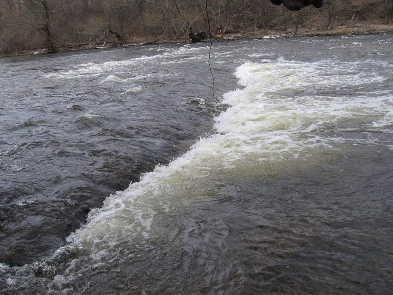
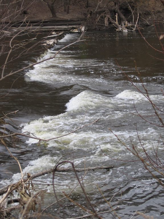
Width: 175', Length: 40-80' Those of us who frequent this river tend to just initialize each of the main drops and playspots. You will notice these initializations in parenthesis on the headers and in the descriptions of this feature and most which follow. Beginning back in 2020, MMSD headed a coalition of entities to modify the riverbed to enhance fish passage for Lake Sturgeon and Northern Pike. At initial planning meetings, public input strongly suggested many people wanted the 'falls' to remain intact. In 2025, two channels (river-left and river-right) were excavated from well-upstream, virtually eliminating any vertical jump (no ledge, no falls). While the project documents repeatedly promised to keep *'some semblance'* of the falls, the results completely belie those claims. This project destroyed *most* of the interest here for whitewater boaters. All the features which formerly existed (*Big Dog, the Micro Wave, Little Dog, Beer Garden Chute*, as well as the fun short 'boof' off the main drop) are gone. At some low flows, some waves and holes will allow some play. Stronger paddlers may be able to actually do repeat play on a few of them, but that will be a challenge at most flows. **To the left:** about 15-20' of bedrock alongside the vertical stone wall shore was untouched, and will be dry shoreline at low to moderate flows. Bedrock in he next 40-50' of width was removed. Early in this stretch, a small, shallow wave (*'False Hopes'*) might allow surfs at a very limited range of flows, but has no eddy for repeat play. This is followed by a pool area until where the ledge used to be. A bit of the lip of the falls was left in place, but not enough to make any meaningful feature at nearly any flow. (I call this area *'Broken Promises'*.) At flows under 400 cfs, this channel will be scrapey (nearly impassable). As flows rise above that point, this channel will be the better choice for novice paddlers, as they will not have to avoid the two features in the right channel. **To the right:** the bedrock slopes gradually to meet the bottom pool (with no ledge remaining). Two or three playable features can exist down this stretch. Just as the current quickens, just right-of-center, *'Entrance Wave' (or 'EW')* is a shallow breaking wave that will allow tame surfs and flatspins at flows in the 400's(+/-). This will be COTF (catch-on-the-fly) one-shot (no repeat play), since there really isn't any eddy here. About midway down, in the right half of this right channel lies *'Mid Wave' ('MW')*. This is somewhat bigger a breaking wave, but also generally quite shallow. It has a small upstream 'staging eddy' against the right shore, and there can be slackwater to river-left. Strong paddlers may be able to power up that slackwater for repeat play. Recreational paddlers not willing to risk getting wet or possibly capsizing should likely stay right of 'EW', but aim to get left of 'MW'. Finally, about where the ledge/falls used to be, at some moderate flows, a possibly surfable green wave *('Bottom Wave', or 'BW')* can occur, with good eddy service river-right. At high flows, nearly all of these just wash-out, leaving nothing worth calling whitewater. **Between river-left and river-right:** parallel to the flow, a fairly straight ridge of bedrock (mostly vertical but occasionally slightly 'stepped') was allowed to remain. At some low flows, water trips across this from left channel to right channel. While this may present some odd play or alternate routes, mostly it will be shallow/scrapey at low flows (as nearly all water will be in the right channel), and will be awash enough at higher flows as to minimize or completely eliminate any meaningful opportunities. **Boaters (and fishermen) need to be aware that a lot of rocky rubble remains in the pool downstream of where the main ledge used to be.** Anyone upside down or out of a boat will very likely have an unfortunate encounter with some of these rocks. This location can be done as a park-and-play (PnP), using the parking lot near Estabrook Beer Garden, carrying down (as described previously), running and playing whatever you may find worthwhile here (multiple times, if desired, carrying up the river-right portage path), finishing by coming ashore river-left at the end of the boardwalk, to carry back up the steps to the parking lot. It may also be worth doing a short shuttle (or boat down / carry-up+paddle-up) to catch this area and the next (U-Park Ledge) in a short (0.8 mile) run. Fishermen have long visited both shores in this area (while the falls were in place, blocking passage at most flows of all but the strongest swimming fish). With destruction of the falls now facilitating passage for nearly all fish at nearly all flows, concentration of fish will diminish significantly. (Concentration of fishermen may eventually diminish a bit, though good parking and good access will still draw them here, especially during seasonal spawning runs of trout and salmon). My experience has been that summer fishermen (primarily for panfish and bass) tend to be fairly amused by and tolerant of our presence, whereas (with unfortunate regularity) the spring and fall sport fishermen (for trout and salmon) more often tend to be less tolerant, less willing to share the river. We've been told (by fishermen) that WE are breaking the law by 'interfering' with their fishing, been threatened with calling police or DNR-wardens, been intentionally cast-at with fishing hooks, and had rocks thrown at us. (I'm not saying every sport fisherman is so belligerent, just that some are.) It should go without saying to try your best to be observant of their lines and avoid interference as much as reasonably possible. Often if you calmly and politely talk with them and 'negotiate' a bit, they'll (willingly, or begrudgingly) share the river. If/when you encounter someone fishing, who seems less willing to share, it may be best to just move on rather than pushing the issue into further conflict and potentially making matters worse, not only for yourself, but for all paddlers.
Beginning about 0.5 - 0.6 miles from your put-in, the river-right bank largly clears of trees to become a grassy slope. You'll see the lightposts high up river-right in the ***U-Park*** ( ***U*** niversity of Wisconsin-Milwaukee ***Park***-and-Ride lot). This boulderbed shoals (class I+/II- riffles and rips) leads around a sweeping right-hand bend for roughly 1/4 mile. At some flows there are a few fine catch-on-the-fly shallow-dished waves to surf. There is also left-of-center (kind of midway down) one large rock sticking well out of the water which has a one-boat eddy to catch, or may allow a rock-splat or rock-boof at some flows (for those who are so inclined). As soon as large trees populate the river-right bank, you want to be center-to-center-right for this double-ledge (bedrock intrusion). (You'll miss any chance at catching it if you are left-of-center as you approach this area!) The first ledge/wave (maybe 20-30' in width) lies center-stream, and the second one (40-50' in width) lies just downstream stretching from right-shore nearly 1/3rd across the river. \=\=\=\=\=\=\=\=\=\=\=\=\=\=\=\=\=\=\= At flows in the 400-600 range, very sweet beginner/intermediate play is possible here. Front surfs, side surfs, and flatspins may be practiced to your heart's content. As flows get into 600-1000 CFS, better playboaters may also manage some backsurfs and blasts. At moderate flows, a sweet attainment move is possible, coming off the lower (main) wave to 'surfers right' (toward center-river), ferrying across a bit of current, paddling up a break (slackwater) to another minor diagonal ledge/wave, surfing it to the upstream/left (toward river-right), and paddling up slackwater to regain the upper wave. At higher flows (above 1000 and into 2000-3000 cfs) this location develops waves (often with sweet soft foam-pile). Surfing will be marvelous, but mostly 'catch-on-the-fly'. It may be possible to regain the bottom wave/hole by paddling tight to river-right banks, but more likely any repeat play will be by going ashore to carry back above the waves, severely limiting most boaters' interests. \=\=\=\=\=\=\=\=\=\=\=\=\=\=\=\=\=\=\= The next features downstream ( *'Timber Dam'* and *'The Plague at Locust'*) are generally pretty lame when flows provide best play here and N.Ave., so boaters may wish to maximize play (and cut out the nearly 2.5 miles of mostly uninteresting paddle between) by playing U-Park Ledge, then driving down check out North Avenue. This area is easily accessible as a park-and-play by taking Capital Drive to Humboldt Boulevard, then heading north on the dead-end-stub. During the UW-Milwaukee school year, I have never had any problem parking in the front edge of their lot, but signage indicates the lot is closed when school is not in full session. About half-way back toward that lot, there is a short graveled stub to the left (and up a bit of a slope -- next to an old sign about some dog center) which similarly had never been a problem for parking. However, arriving there some years back to park-and-play UPL, a squad car was parked on the gravel stub. I stopped, rolled down my window to chat with the officer to casually inform him of my plans, and ask if there was any problem with parking my vehicle there while on the river. He informed me this area was private property of the TV station, and that they would have my vehicle ticketed and towed, and suggested I park in the UPark lot instead. I mentioned to him that there was very specific signage indicating that on days when the shuttle buses are not running (weekends and all summer) it is illegal to park in that lot. He then suggested I park on the road heading in/out of that lot. Amazed, I expressed that while there are no signs specifically saying 'No Parking', neither are there any marked parking spaces, thus I would expect my vehicle to be ticketed for being parked (and 'abandoned') in a traffic lane. He then suggested that I could drive passenger-side wheels over the curb and onto the grass, to park driver-side wheels as close to the curb as possible, which I subsequently thanked him and did. The entire exchange was courteous and noncontentious (though more than a bit perplexing). This is what I have been doing for access here ever since, but have always wondered if (at some random time) some other officer or individual might decide that this is not a legitimate way to park a vehicle. So ... it leaves me in a bit of a quandary. I've never had a problem parking in the U-Park lot when shuttles are running, and never had a problem (prior to this encounter) parking on the gravel stub when the lot is closed, and now never had a problem with parking on the grass with 'inside driver's side' tires nearly against the curb. Armed with that info, you are each on your own to choose your parking option if/when you decide to access the river at this location!
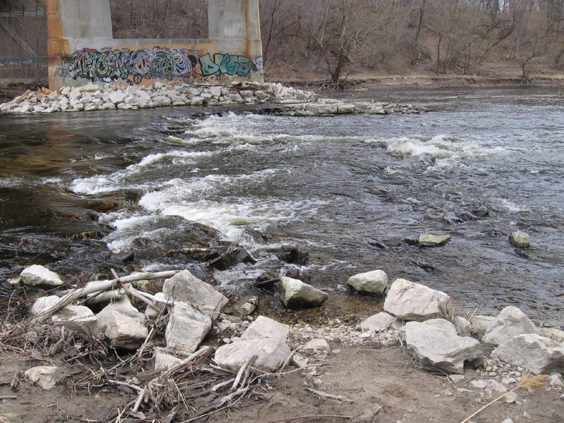
The first of three road bridges you'll pass under on the full run is Capitol Drive. A shallow, rocky shoals (at least, at low-to-moderate flows) will be encountered. Best depth is generally off to river-left. At higher flows (above 500 cfs), these shoals are fairly well covered (no special 'line' or maneuvering is needed), and (most generally) no playable features occur. (Though I have had one boater claim surfing some feature here!)
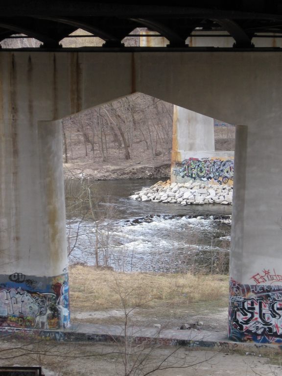
An old timber dam was used by the breweries to harvest ice from the river in the days before modern refrigeration. Remnants of it extend from river-left (and, to a much lesser extent, from river-right), blocking nearly three-fourths the width of the river at flows under 800 cfs. A small, smooth wave forms in the gap, generally being better the lower the flow goes (all the way down to minimal summer flows!). At those low flows, very well-defined eddy-lines are present in the deep pool below the flanks of the timber dam. This spot can offer great opportunities for bow stalls and stern squirts, as well as 'old-school' pirouettes.
Beginners may practice river-running skills such as peel-outs, eddy turns and ferrying. A great training exercise is doing 'figure eights': peeling out of one eddy, crossing the current, catching the other eddy, paddling up it a bit, then repeating the process coming back to complete the '8'. It's great beginners practice for working on boat-leans and carving turns. Since there is great depth here (at all flows), a relatively strong current, relatively strong eddylines, and a huge 'recovery area' downstream, this is a great low-consequence spot to practice 'combat rolls' (rolling your boat in something other than the dead-calm water of a pool or lake).
As levels exceed 600-800 cfs, water increasingly flows over the remnants of the dam (I.E., the entire width of the river), the eddy lines diminish, and there is minimal whitewater interest here as a result.
Note: this site may be done as a 'park-and-play'. Driving on Humboldt Boulevard until just a bit north of Locust Street, turning East on E.Chambers Street. Proceed to near the end of this dead-end for street parking, then carry down the pavement (to the left of the gate and fence around the pumping station), stepping over or going around a chain strung between posts (stopping vehicular traffic on this stub), and continuing to walk straight down the grassy area to the river.
Increasingly (since Spring of 2013) time has been unkind to us. High water and ice-outs continue to knock out old timbers from the dam. As a result, the dynamics and play potential of this spot have been reduced. Water is not funneled as narrowly as before, and the eddy lines are not as well-defined until flows drop under 300-400 cfs. (Still playable, just not as good as previously.)
Directly under the Locust Street bridge, the main channel (to the right of the bridge pier) contains rocky rubble (including cement and rebar) which creates a short rocky pitch.
At levels somewhere above 500 cfs most of the debris is covered, and there is little more than splishy-splash rips. (Perhaps a couple of barely surfable waves.)
At lower summer levels this area changes to be potentially more treacherous to beginners or non-whitewater paddlers, potentially marginally more interesting for whitewater paddlers. At these lower flows, piles of rubble create more constricted flow. Canoeists may be best advised to kneel into the bottom of the canoe: getting your weight off the seats, lowering the center-of-gravity, and increasing your stability. Do NOT raise your arms and your paddle high overhead! Keep paddling!! (Or, consider portaging, keeping in mind, however, that any wet rocks on or near shore will be very slick! Watch your footing!).
Boaters who flip or swim are warned that there is a great deal of shallow coarse cement rubble in the main outflow in the pool below the main pitch. DO NOT ATTEMPT TO STAND while in the swift current! Attempting to stand (or to swim head-forward/face-down) in shallow, swift moving water is VERY likely to result in bruised and scraped up knees and shins! Instead, assume the 'swimmer's position'! (Floating as near the surface as possible, face up, feet downstream.) You WILL encounter rocks and cement with your shoes, your butt, and your (PFD protected) back. Wait until you are downstream in the calmer water in the pool before you even think about trying to find bottom, stand up, and collect your boat and gear.
There is a much smaller channel to the left of the bridge pier which has far less rubble and debris in the flow. At low flows (120-250 cfs) when the main channel can be most treacherous for beginners and non-whitewater paddlers, this less obvious channel is unlikely to be a viable alternative to the main channel, since shallow sandbars in the pool below may 'ground out' your boat.
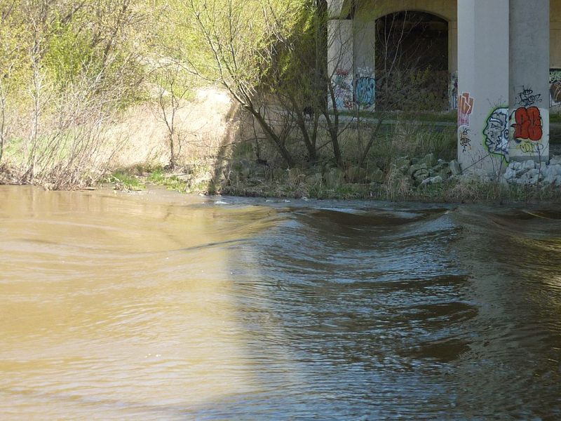
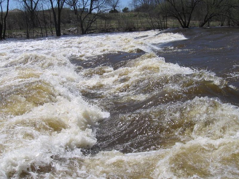
Nearly a mile of flatwater downstream of Locust Street leads to the North Avenue Bridge, where you'll encounter the start of ~300 yards of swift water and waves, before the remnants of the North Avenue dam (now spanned by a pedestrian bridge).
It doesn't offer much for the full-out rodeo crowd, since no features (at virtually any flows) have enough depth or retention to allow any vertical moves (cartwheels, stalls, squirts) or aerial moves (loops, etc). However, when flows are in the 800-1500 cfs range, it will offer sweet soul-surfs on two to six (or more?) waves, and at some flows allows sweet flatspins (or slightly elevated spins) on a couple of the waves. Most of the possible waves are detailed below.
Unfortunately (as mentioned in an 'alert' at top of this page), these features are very likely to be destroyed within a few years (from 2025). Enjoy them while you can!
A 'fault' in the paver-block bottom creates a surfable/spinnable wave which (much of the year) sits in the shadow of the North Avenue bridge (hence the name). It is at its best from 300 to 1000 cfs. Above that level, a wave diminishes, and will be more difficult to regain as the river-left eddy disappears (or, at least, becomes harder to catch to paddle up to and across to what little 'dish' is there at higher flows).
UPDATE: Heaving from winter freeze-and-thaw has torn-up and pushed around some of the paver-block 'bedrock', causing very unfortunate changes to this feature (and elsewhere down this stretch). While 'Shadow' used to have a sweet pocket and pile, it is now more often only a green (brown) wave. From river-left, it is more challenging to ferry across to the main/center wave for repeat play there. The main/center wave still allows sweet front-surfs and spins, but is more challenging to get to (from the river-left eddy) at most boatable flows. This means (for many paddlers, at many flows) that Shadow will likely be a catch-on-the-fly, one-and-done ride.
Immediately after the bridge-piers river-right (tight toward shore), a 'heave' in the paver blocks will rake/scrape the bottom of your boat (or will be completely exposed) at flows up to 600 cfs, somewhat blocking access to the river-right eddy immediately downstream of the bridge.
At some range of flows (perhaps 900-1100) a smooth, surfable wave may exist right-center 1/4th of the river. When present, it is catch-on-the-fly, one-and-done, thus the name 'Homeless'. (As in, there is no eddy from which to do repeat play. Also a reference to homeless individuals who stowed stashes of sleeping bags/blankets etc under ends of the North Avenue bridge in the years before the UW-Milwaukee dorms were built on both sides of the river. Increased traffic and patrol of these areas has displacing the homeless to other less travelled locales.)
Time of year matters! Waves are 'broken' in summer (not forming at flows they'd be great late-fall and most of spring)! Descriptions of features (and water levels they're 'in') are for *non-summer* situation! From 600 to 1300 cfs, whitewater playboaters should get surfs, flatspins, and slightly elevated spins. (There's never enough retentiveness or depth for full-vertical or aerial maneuvers.) A shoreline 'escalator eddy' river-right allows easy repeat play. High water in 2008 changed this feature. The former diagonal wave (looking like it would 'typewriter' you to river-left) no longer exists. Now (when it is 'in'), it is a narrower wave or breaking wave/hole, center-river. At some flows, a secondary wave (immediately behind) is also surfable. The names of this feature and those which follow pay homage to Christopher Latham Sholes who is credited with (improvements on efforts of others and a number of patents which led to) the first commercially viable typewriter.
At some flows (mostly in the 800-1600 range) a sweet wave forms very near the river-left shore, just a wee bit behind Typewriter Wave (TW). It has no eddy, so the only way to catch it is coming off the 'surfers-right' shoulder of TW, in control, to charge/slide across onto Backspace. While I've never been able to pull any moves in it, it is a sweet surf, and sets you up for the next feature.
Just downstream of ***Backspace*** lies ***Carriage Return***, a better-formed wave, sometimes having breaking pile. At 800-1300 cfs, this offers front-surfs, side-surfs, and spins. For younger readers: Before computers, typewriters had a 'platen' on a 'carriage' which held a sheet of paper, and which moved left as one typed. When electric typewriters took over, some models had a type-ball on a 'carriage' which traversed the page (which no longer needed to move left and right). The keyboards on these typewriters had a 'carriage return' key (where the 'Enter' key is on modern keyboards) to reposition the 'carriage' to the left margin of the paper and move the paper up just slightly so the typist continued typing the next line. This wave is named to honor that history.
Shifting more toward center-river (below *Carriage Return*), a few wider wave/troughs often form (generally at levels 800-1300 cfs). Some of them tend to surge, cresting and flattening out (at least at some flows), which can make them difficult to catch and ride. If your timing is right, they make a great challenge to see how long you can ride a constantly-changing wave! And, I will confess these may be bending and stretching the analogy just a bit. On the typewriter/keyboard, the 'Shift' keys are positioned at lower-left and lower-right, while these waves form pretty much dead-center-river. However, I liked keeping with the 'special-function' keys rather than naming them 'V', 'B', or 'N' waves (after the letter-keys more lower-center on the keyboard, especially since 'N-Wave' has been the chosen name for a playspot up in Neenah, at a pipe-outflow/bypass at the dam forming Lake Winnebago.)
A final fault in the paver-block center-river creates a surfable wave, perhaps best 900-1200 cfs. At higher and lower flows its barely noticeable, or may surge. (You may catch a brief surf but be dumped off as the wave appears and disappears!)
Note: At least one boater (upon flipping) has had a 'close encounter of the worst kind' with rocks in the outflow from this wave. (Fortunately, he 'tagged' it with his back and shoulder, not his head/helmet.) Many shallow rocks lie in eddies to both sides, as well as downstream (above and through the final rocky pitch). All of which is to say, this is not a good place to play if you are not confident of staying upright, or if your roll is not quick and sure.
If you eddy-out before dropping into the Rubble Field, a river-right eddy allows you to paddle to above Typewriter Wave, and a river-left eddy allows repeat access for Return Key through Space Bar. When all features here are 'in', whitewater play-boaters often forego shuttling, doing just this best park-and-play on the river!
Novice paddlers may find this splishy-splash exciting, or a PITA at flows under 200 cfs (even worse under 100 cfs during droughts). Whitewater boaters may find minor play on a wave or two (perhaps better/best ~150-300 cfs).
Over 400 cfs, rocks are adequately covered to allow passage most anywhere. As levels drop, boats grunge-out on shallow rock. Anyone upside-down in a kayak or out of any boat will likely be bruised and battered by large rock rubble lining the riverbed.
If out of a boat in the river, if water is deep enough, float on you back, feet downstream. If it's too shallow to float or swim, crawl on hands and knees so you don't slip and fall (bashing knees/shins/wrists/hands/elbows)! Footing will be trecherous on slippery rocks in the water and on shore.
Know the dangers of foot entrapment! Do not stand in strong current when rocks are present! (Search+read: 'whitewater foot entrapment')
NOTE: From a media article: 'In 2013, Big Lake water levels hit their lowest in recorded history. But now, just four years later, they’re the highest they’ve been since 1997 – rising four feet in just that time.' As a result, for about five years (from 2017 through about 2022), this final rubble field (and minor features it occasionally offered) was mostly swallowed up by the unusually high backwater of the lake. The lake level has now receded, and rubble field is back.
Multiple choice!
Halfway between North Avenue and the footbridge (flanks of the old dam), before shallow rubble shoals. The paver-block riverbanks may be slippery in the water or if wet on shore, but they provide a smooth, stable surface to exit your boat, and the shore slope is not steep. It is most advantageous to use this exit-option if you wish to carry up for additional surfs of Shadow (et.al.), since there is little-to-no additional play down the remainder of this stretch. Going any further down just nearly doubles the walk back up!
Beyond the rocky pitch, the right shore is lined with trees and shrubs until midway to the dam/pedestrian-bridge. There's a clearing, then one final good-sized willow. Exit your boat (from a somewhat precarious eddy), step onto quarry rock (likely SLIPPERY in/near the water - BE VERY CAREFUL!). Carry or drag boat a couple of steps across irregular quarry-rock, before good footing on gabions (wire baskets filled with rock) and then grassy shore. Carry upriver to rerun/replay this stretch, or carry to your vehicle.
The remaining take-outs are all beyond the pedestrian footbridge. NOTE: At flows above 1000-2000 cfs there may be DYNAMIC swirls and boils (even small whirlpools which form randomly!) as the fast water meets flat water here. Above 2000-3000 cfs, this area can get downright wicked looking, filled with all manner of floating debris! However, there is nearly no reason to boat here at those flows, as there are nearly no surfable features!
So, a number of options exist below the pedestrian-bridge.
3A) Stay far river-right under the pedestrian bridge. Paddle immediately to shore, taking out VERY NEAR the dam, then hike up a very steep, rocky embankment. This is a steep, awkward, inconvenient climb (recommended only for the most long-legged, strong, and stubborn of boaters).
3B) Stay center-to-left under the pedestrian bridge. Wait until well-downstream of the dam to head to shore at one of two or three locations with Lannon-stone steps at shore. DO NOT USE 'UNIMPROVED' areas of shore! It will be best if you do NOT use the first spot you come to, since it is a longer walk/carry to a place to get to street level. From the second or third landing, you will see steps running up the high embankment to street level.
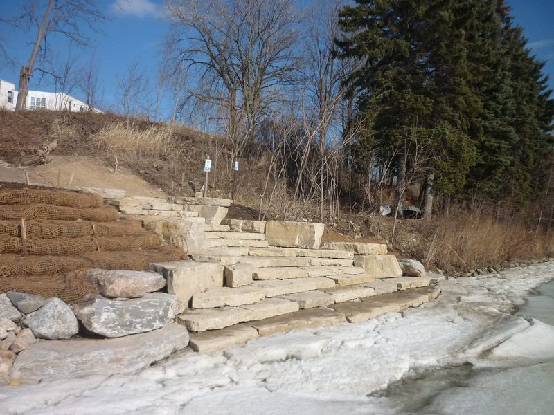
3C) Stay in the current nearly all the way to the vertical steel plate left shore wall. Stay river-left (or you'll actually be paddling against the eddy current below the dam!), not heading to river-right until you can see the Humboldt Avenue bridge and buildings on river-right shore. An obvious landing with huge quarry-rock steps (as shown in the photo) or . . . very immediately past that, a more convenient gravel landing for kayaks. (Depending on water levels, it can be extremely awkward climbing out of a kayak at the high quarry-rock/step, so you may wish to take advantage of the gravelled landing!) A fairly steep gravel trail leads upslope to Riverboat Road right alongside a former single-family home (now offices for a river-related non-profit).
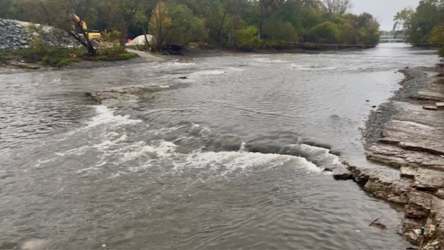
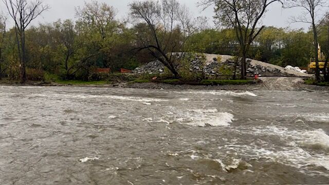
Oct 20, 2025
Instream work at Estabrook Park Ledge (to facilitate fish passage for Northern Pike and Lake Sturgeon) is nearly complete. This is what remains of this once iconic spot on the river.
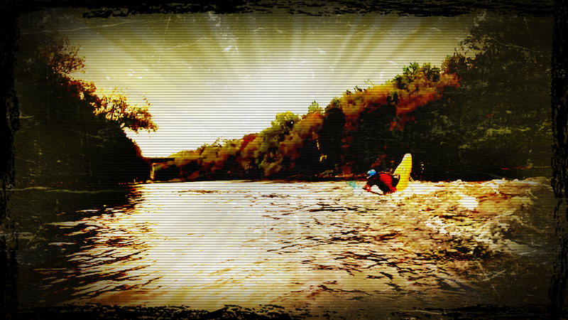
Nov 12, 2014
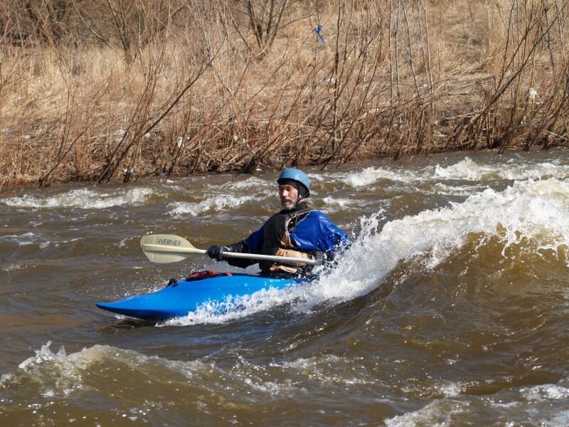
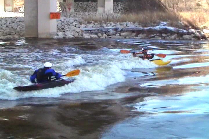
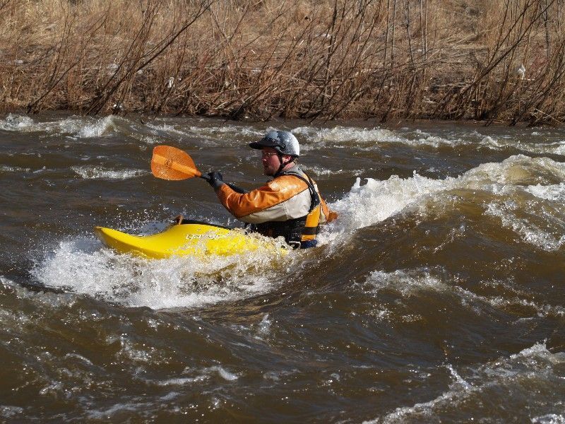
Tony Catania playing the eddy line at Timber Dam
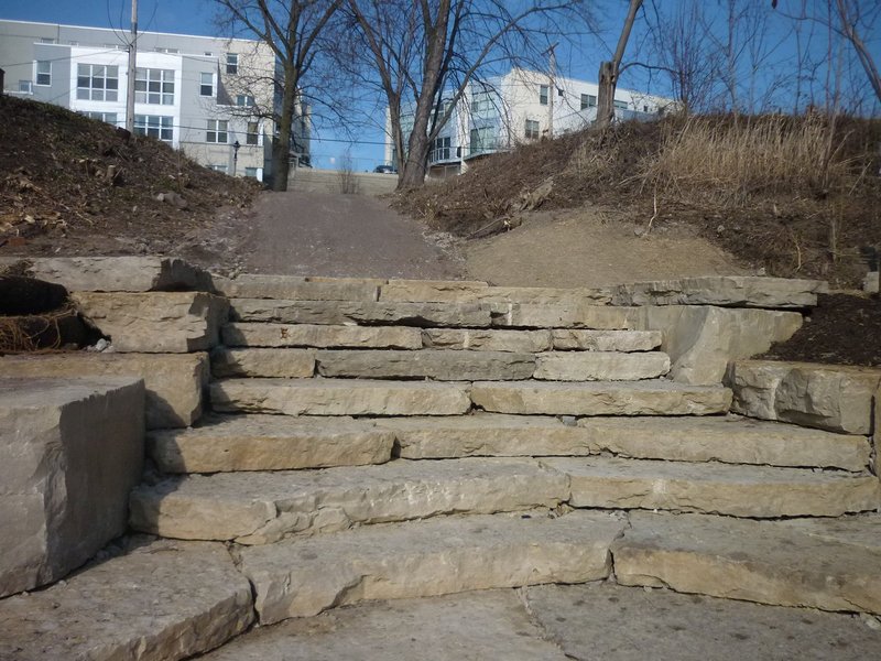
Mar 19, 2012
Neighborhood groups are funding projects to improve the area around Riverboat Road to turn this area into a park. Included in those projects has been a significant improvement to the landing. Formerly there was a steep sloping old concrete slab, with fist-sized-rock path leading uphill. Steps of quarried rock have been created down at water level, and the path has smaller, much more 'foot-friendly' gravel/chip surface. (Hopefully this will not erode too much with heavy rains . . . I have my doubts.)