Milwaukee
C) Estabrook Park to N.Riverboat Road (PnP or up to 3.6 miles)
Having taken part in a 2015.12.16 gathering to discuss and 'help shape' the project regarding the 'Area of Concern' (AOC) has lead to a different understanding than previously reported. A utility transect in the riverbed immediately upstream of the North Avenue bridge is still functional and must remain for the foreseeable future. This means project will not be able to eliminate the gradient which exists between that bridge and the pedestrian bridge (straddling the flanks of the former dam).
Hydraulic dredging will be done on contaminated sediments in the riverbed, with miles of pipe temporarily laid into the riverbed and harbor carrying the slurry to the Dredged Material Management Facility (DMMF) south of Jones Island. Contaminated soils on shores will be excavated and dumped into 'mixers' which will pull water from the river to create a slurry which can then also pumped to the DMMF. Theoretically, then, no contaminated soils need to be trucked from any point on the river to the DMMF.
The shoreline excavation will lower the floodplain (in many places from the former dam to Estabrook and possibly beyond), allowing the river to spread much wider at high flow, reducing peak volumes of water heading downstream as those new floodplain areas fill with water. This should bring the potential for slightly longer periods of moderately elevated flows, as those floodplains more slowly drain much of that temporarily retained flow. (I.E., could mean more days of more favorable flows at N.Ave.)
Talking with a representative of the company which will do that dredging, I was told that their part of the project will not change the present configuration of the North Avenue riverbed (I.E., the existing paver block and quarried rock). However, I am aware that other discussions are still ongoing regarding making this area more passable by Lake Sturgeon and Northern Pike (two species which are unable to jump up falls or swim up sustained stretches of strong currents). This strongly implies as yet unspecified changes instream to better accommodate fish passage.
Whitewater boaters who live in the greater Milwaukee area are urged to keep aware of meetings which will be taking place across the coming year (or two) to further shape the discussion. Hundreds of people will be involved. No doubt many casual paddlers will voice interest in 'making the river safer for paddling' by eliminating the rocks and rapids at North Avenue. If whitewater paddlers don't attend, interact, discuss, and make their voices heard, then there is no way our specific interests and concerns to preserve the features we enjoy at North Avenue will be given any consideration.
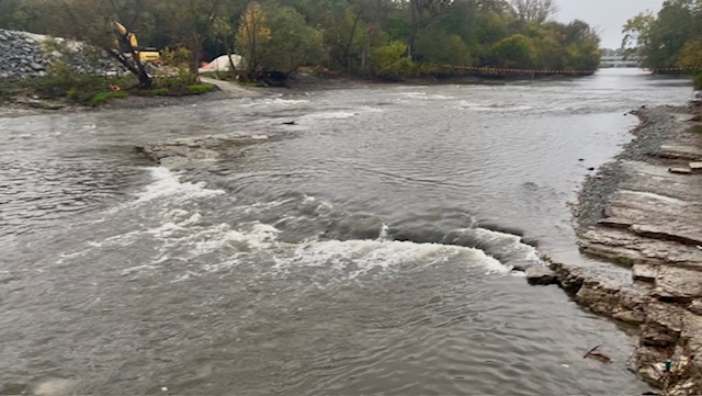
As of mid October, the 'in stream' part of the MMSD project is complete, permanently modifying Estabrook Park Ledge to facilitate passage of Northern Pike and Lake Sturgeon. Significant amounts of bedrock have been removed from river-left and from river-right to create channels of slower moving water. Some bedrock at center-river and along shores remain untouched. Some bedrock at the lip of the falls remains intact at river-left, so a minor bit of 'falls' will still exist, but all nuances of the approach have been destroyed. The new 'featured photo' in the masthead shows what remains (at low water level).
The gauge immediately upstream of this recontouring of the riverbed has not been accurate since the project began, and USGS has disabled the CFS conversion. It will need to be recalibrated across the coming months. Until that happens, the best we can do is report the Milwaukee River in Cedarburg gauge. Drainage here is ~1.15 times drainage in Cedarburg. However, runoff during rains hits this urban part of the river much quicker, so that gauge will be of little-to-no use during rain events. It can only reflect 'base flows' from far upstream.
A description of the project is available here: https://urbanmilwaukee.com/2025/01/15/mmsd-plans-estabrook-falls-fish-passage/
As mentioned in the full write-up, at times of heavy rains, this section of river is VERY LIKELY to suffer from Combined Sewer Overflow (CSO). It is recommended that you check the MMSD website ***************************** http://www.mmsd.com/weather/weather-center ************************* for conditions before running this reach when there have been heavy rains, then decide for yourself if you wish to risk boating in the (diluted) sewage affecting this river. Areas affected should generally be clear (of the bulk of that specific contamination) a couple days after the CSO ends.
No articles