Slate River
01. Beaver Ponds to Oh Be Joyful CG(Upper Slate River)
| Difficulty | V |
| Length | 2 mi |
| Avg Gradient | 85 fpm |
| Gauge | Slate R Ab Baxter Gl @hwy 135 Nr Crested Butte, Co |
| Flow Rate as of 56 minutes | 21 cfsbelow recommended |
| Reach Info Last Updated | August 13, 2020 |
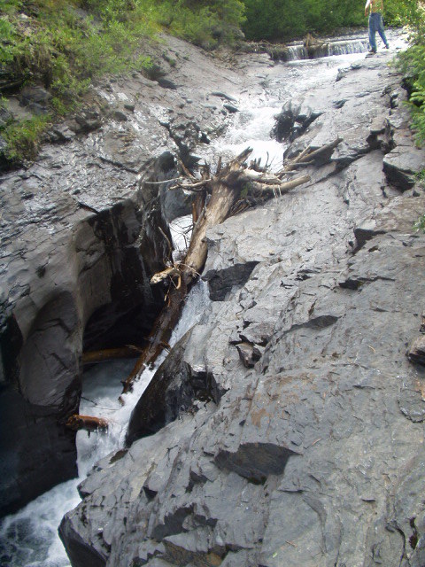
The Slate has a challenging 1-mile stretch of Class 5, but it's not as 'quality' as nearby Daisy and OBJ creeks so it's not run nearly as often. The first rapid, located at the upper end of the campground, is one of the hardest. Look carefully for the shallow shelf in the landing zone on the right, it's going to hit you in the side and is hard to miss. Be heads up for wood, almost the entire length of the reach has avalanche paths coming right down to the river. 1/2 way through the run you will come upon a river wide log jam. Ambitious boaters managed to get a 'technical' channel open through it in 2001, but portage river right and launch off the backside of the log jam if it looks too 'iffy'. On the drive up make sure to scout the location of Wicked Wanda, it is the last major rapid. 'Wicked' does this rapid justice, it funnels down into a narrow twisting entrapment that is almost always clogged with wood. Make sure you know where to eddy out above for the portage.
To access the Slate, turn left on Slate River Road across from the cemetery just after you leave town on the road to the ski area. Drive to FR 754 road, and go down to the gravel bar to the Oh Be Joyful campground. The put-in is about 2 miles up Slate River road where the terrain flattens out.
The Quadruple Crown: Because of the short length and proximity of the Crested Butte creeks all 4 of them can be run in the same day. The East River is the best to start out with; it has the largest flow and the least gradient of the four. Next in line is Daisy Creek. Just continue downstream after Daisy to the confluence with the Slate River; there will be about 1/2 mile of slack water until the first rapid. The takeout for the
...