Chestatee
2 - Town Creek Church Bridge (a/k/a Garnett Bridge) to Copper Mine(Grindle Falls/Grindle Shoals Section)
June 14, 2003
| Reporter | Chris Gorman |
After reading the American whitewater page i was under the impression that Grindle falls consisted of only a 10 foot waterfall that was split by and rock
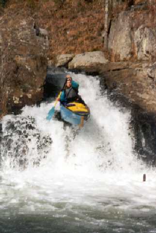
The truth is that there is more to Grindle falls than just the split-rock waterfall. There are about 50 more feet to it :) When I came to the top of Grindle falls it was quite a horizon line ('a little big for ten feet' I thought)
I went with most of the flow down the right side of the river which I find out later totally misses the falls pictured on the AW page. I am not sure how to get to the top of those falls (which were at the left river bank). The right side drops through three 10-15 foot drops/slides. I turn around and see the pictured falls (Quite a sight actually, I will get pictures up on AW when I get the film developed). Then I go down a 7 foot slide, then a 15 foot one to end Grindle falls.
After that it is flatwater until the coppermine rapid which is directly before the take-out. The best line is through the center shoot with some left angle. Also there is a really interesting copper mine at the takeout (an actual mine). It is a huge cavern that someone told me has an underground river beneath it.