Bluegrass Creek
Tunnel outlet to Highway 34
| Difficulty | II-V+ |
| Length | 18 mi |
| Avg Gradient | 67 fpm |
| Reach Info Last Updated | November 19, 2020 |
This is a bizarre post-season run courtesy of the ranchers of south-east Wyoming. The water in Wheatland Reservoir #2, which comes from the Laramie River, is siphoned off into Bluegrass Creek. You will have a 17 run with 20+ fences over the creek, 4 V to V+ rapids, 2 or 3 miles of fun III/IV, and 13+ miles of swift moving Class II.
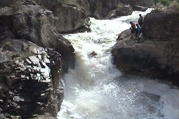
The put-in is truly bizarre with the water coming out of a hole in the side of the hill and transforming an otherwise sagebrush filled desert draw into a class V paddler's oasis . The stream-bed is only as old as the diversion, which was completed in 1886 by Chinese immigrant labor (history lesson available here: http://widirrigation.com/Home/About). This inital 2/3 of a mile beginning at the mouth of the Wheatland Tunnel contains 3 of the major rapids (aka glorious boofs) on the run. Those without time to complete the entire run to highway 34, or simply wanting to milk as much whitewater out of their day as possible will enjoy lapping this section via a faint trail on river right. I also recommend using this trail to scout the entire top section, there are very few eddies and even fewer places where it is easy to get out in this first section of action.
The unnatural nature of this run is intimidating, and although it does tend to paddle more cleanly and easily than immediate appearances would indicate, you will immediately notice while scouting that this is no place to swim and a scary place to find yourself upside down. Despite it's bizarre nature, the top 2/3 of a mile is exceptionally high quality with 3 waterfalls of varying height and technicality. A splashy and hole strewn run out below the waterfalls careens around several blind corners before unceremoniously dumping paddlers into the main channel of Bluegrass Creek. Don't forget to scout this last section, a midstream boulder hidden in the blind corners claims more carnage than any of the spectacular
...
Stampede!(V+) is an 12' waterfall at the put-in, which funnelizes(aka - no eddys) you into the next 8' pourover that slams into a jagged wall. After that you've got about 150 yard sluice like rapid.
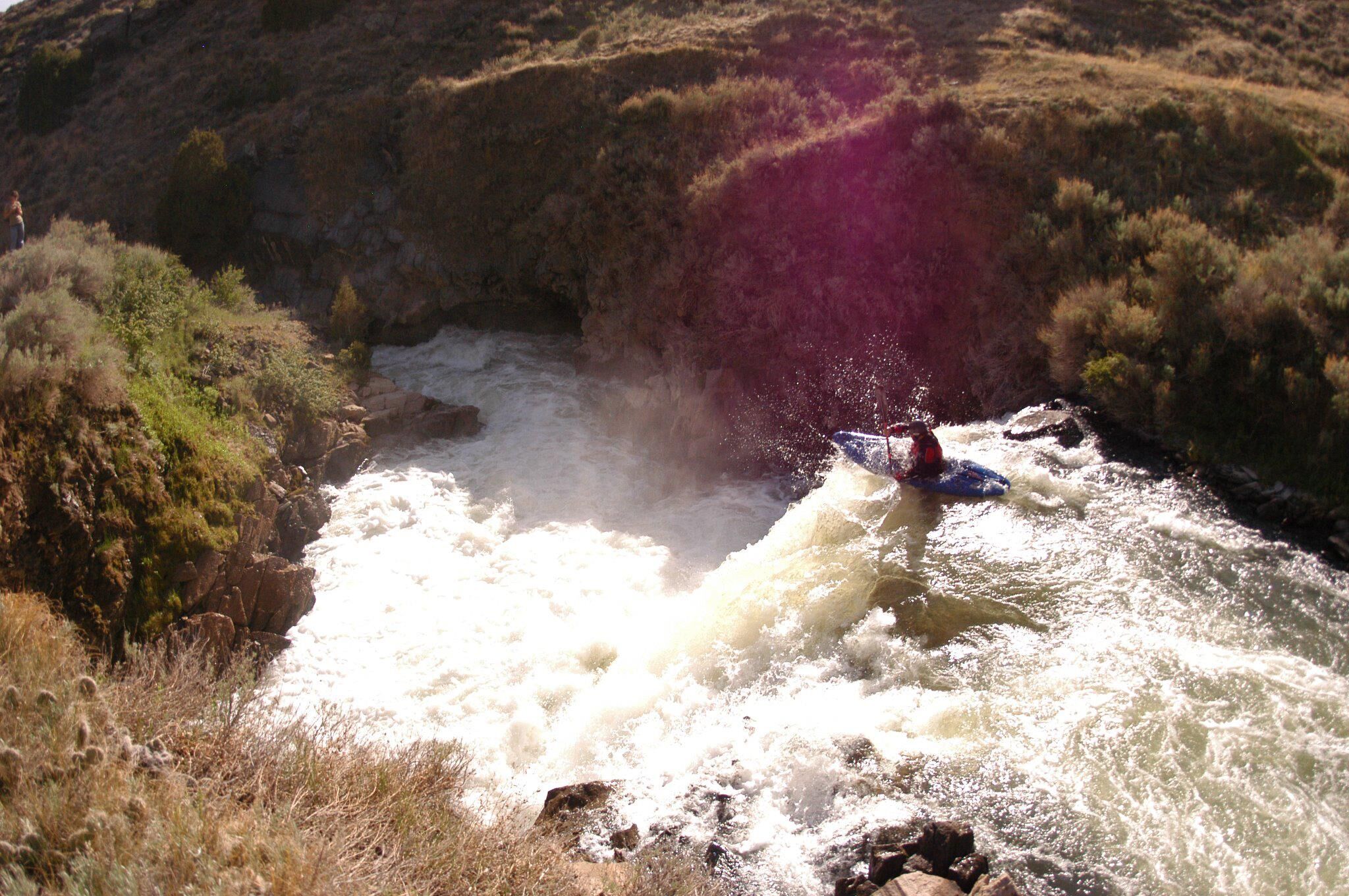
Bucking Bronco(V+) has 2 or 3 severe lateral cross currents before launching you off a 10' ski jump of a ledge. The run out to Bucking Bronco is about 200 yards of swift eddyless IV+ to V-(depending on waterlevel or who you ask).
At this point you will want to keep a sharp eye out for barbwire fences, you will most likely encounter 20+ before the takeout. Some are in better repair than others. For most of them I was able to find a weak spot and push myself under the wires. But watch out for those well constructed ones with tight wires. There are also a handfull of lowhead dams, we were able to run all of them.
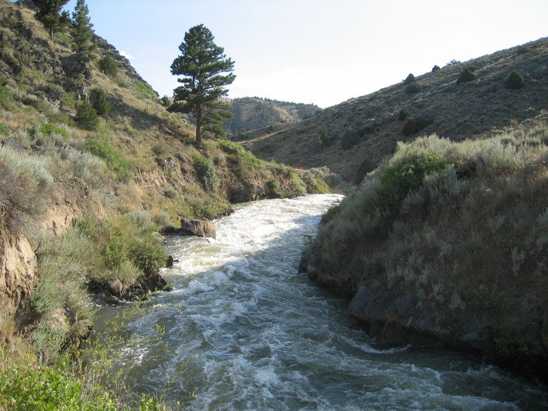
Somewhere around mile 10 to 12 the creek drops into a scenic bedrock canyon. The rapids in here are of the highest quality III with the occasional IV and one IV+. After 2 or 3 miles of good times the rapids will mellow out again for a while before reaching The Main Event
The Main Event(V) looks like something straight out of California, it is a series 3 big drops carved into smooth bedrock. 1. There is a long bedrock slide that slams into the river right wall, creating a massive hole/pillow 2. Then the creek charges off an 18' waterfall into a cauldron. 3. There is a short inescapable gorge before a final steep 18' slide with a stout hole at the bottom.
Pop some Advil and continue downstream for the final 5 or 6 miles of Class II until the highway. There are some ranch houses near the creek in this final stretch, and this is the location of those well constructed barbwire fences over the creek.
The takeout. One of the worst fences is right under the bridge, class II with a complete lack of a good eddy above it.
Sep 17, 2019
As of September, 2019 there was one fence requiring a portage. It is below the Main Event and is fairly obvious with large iron upright posts anchoring it inplace. There is a quick and easy portage on river left.
Also, beware of two fences in rapid succession directly below the highway 34 take out bridge. If possible take out above the bridge as soon as it becomes visible.
Sep 14, 2011
The Wheatland tunnel was constructed between 1883 and 1886 by the Wyoming Development Corporation. Canals #1 & 2 were constructed at the same time. The reservoirs were constructed a bit later; 1901 for reservoir #2.
http://waterplan.state.wy.us/plan/platte/atlas/lower/lower\_agricultural\_irrigation\_districts.htm
Jul 19, 2003
small version of this photo...