Lamington
Chester to Pottersville(Black River)
January 9, 2006
| Reporter | Stephen Strange |
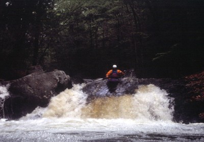
Unless it has been replaced in the last few months (I'll go check on it soon), the sign above the gauging station is the same one which has been there for years. It's indicated on my guide map, but isn't in-play and can be ducked under unless the water is extremely high. (If it was low enough to decapitate people, it would have disappeared years ago, thanks to my hacksaw) As for the 'falls' after the house on river right, unless there's been some major geologic activity that I'm unaware of, this rapid consists of a 2-3'ledge with a small eddy below it on the left, followed by a 4'ledge, immediately followed by a slide to the left which drops about another 3-4', which pools/pillows back to the right (now downstream) and drops another 3-4' feet or so. I refer to this rapid as 'Nasty Rapid' on my map because of the upleasant looking rock at the finish in low water. It is best to scout it from river left. I have run every inch of this run a number of times and though I wish there was a 20ft falls, I haven't found it yet.