Poultney
2. Lower (US Route 4 to Carvers Falls Dam)
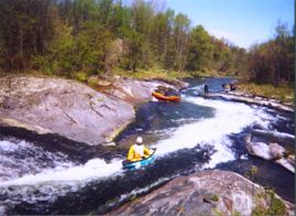
September 7, 2011
| Reporter | Hana Skirkey |
We went to the Poultney today, 9/7/11 @ 750~ish CFS. Awesome time! No wood in the rapids. The only noticeable differences were:
1. The fence behind the Visitor's Center along the river came down, making for a much easier seal-launch.
2. The banks are eroded a bit, but did not change the main features of the river.
3. There are some trees down in the flat in-between parts.
4. There is a strainer after the last rapid where the river divides in two from a large sand bar. The right channel is COMPLETELY blocked by a river-wide strainer. After the last rapid, just make sure you hit the left channel.
5. The most problematic part of the flooding is probably finding a good spot to get out. The normal portage where the signs are before the dam is very hard to get out from because all of the sediments and clay are new and washed over the banks. We couldn't even walk through it, I sank in to my knees and had to pull my boat right up to me so that I could lay on it and wiggle my leg back out. Don't try to walk through that stuff unless you want to get stuck or sink in muddy clay. We just paddled further down, right up to the RIVER LEFT side of the dam (be careful, the river gets narrow and if you go too far right you'll go over the dam) where the little dam control building is and clambered our way over the bank which is also covered in the same mucky clay. There was a tree that we used to avoid stepping in the muck. Try to spend as little time there as you can, as it's technically trespassing. You can walk to the parking lot by following the chain link fence.